
Fichier:1776 Rennell - Dury Wall Map of Bihar and Bengal, India - Geographicus - BaharBengal-dury-1776.jpg

Fichier d’origine (9 106 × 6 000 pixels, taille du fichier : 16,86 Mio, type MIME : image/jpeg)
Ce fichier et sa description proviennent de Wikimedia Commons.
Description
| Avertissement | Certains navigateurs peuvent avoir des difficultés à afficher cette image à sa résolution complète : elle possède un nombre de pixels singulièrement élevé et peut ne pas se charger correctement ou faire planter votre navigateur. |
|---|
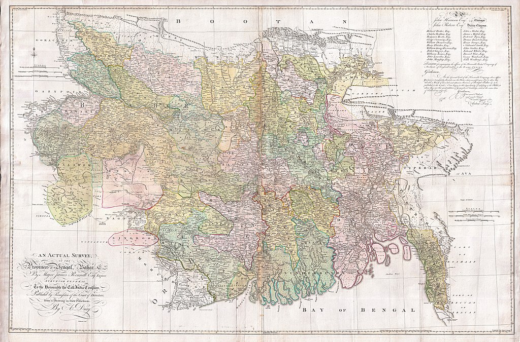
| Titre |
An Actual Survey, of the Provinces of Bengal, Bahar & c. by Major James Rennell Esq. Engineer to the Honorable the East India Company. Published by Permission of the Court of Directors from a Drawing in their Possession by A. Dury. |
|||||||||
| Description |
English: An altogether spectacular wall sized map of those parts of Bengal and Bihar, India. Follows the course of the Ganges River from Varanasi (Benares) eastward to the Ganges Delta and the Bay of Bengal. Includes Varanasi (Benares), Dacca (Dahka, Bengladesh), and Patna among many other important Indian cities. Bounded on the north by the Himalaya Mountains and the border with Bhutan. One of the first accurate maps of the interior of India. Laid out from primary surveys done by James Rennell, the first modern cartographer to map the interior of India. Notes cities, markets, battlefields, fortresses, roads, rivers, offers political commentary, and features some geographical references. Elaborate title in the lower left quadrant. Upper right quadrant features a dedication and letter of thanks written by Andrew Dury, the publisher, to the board of the East India Company. This is the first edition of this rare map – 1776 – as published by Dury. Later editions were published by Sayer and Bennet and by Laurie and Whittle.
Another high quality digitisation is available at the David Rumsey Historical Map Collection: [1] This map was published by Laurie and Whittle, as mentioned in the description by Geographicus for the 1776 map, in 1794. Regions are demarcated in coloured outlines instead of filled colours. A higher quality digitisation than that of Geographicus. Contains parts that are missing at the central vertical fold in the Geographicus digitisation of the 1776 map. Viewable in online Flash viewer and downloadable in MrSID format. |
|||||||||
| Date | (dated) | |||||||||
| Source |
The Bengal Atlas ??, Rennell, James, (1779 first edition)
|
|||||||||
| Créé par | ||||||||||
| Données géotemporelles | ||||||||||
| Rectangle englobant |
|
|||||||||
| Géoréférencement | ||||||||||
| Données d'archives | ||||||||||
| Numéro d’inventaire |
liens Geographicus : BaharBengal-dury-1776 |
|||||||||
| Dimensions | hauteur : 39 pouces (99 cm) ; largeur : 59 pouces (149,8 cm) | |||||||||

|
Cette image a été promue selon les critères des images de valeur, et est considérée comme l’image de plus grande valeur sur Commons dans le domaine : Old maps of Bengal from 1776 by Major James Rennell. La proposition est consultable sur Commons:Valued image candidates/1776 Rennell - Dury Wall Map of Bihar and Bengal, India - Geographicus - BaharBengal-dury-1776.jpg. |
Conditions d’utilisation
|
Cette œuvre est également dans le domaine public dans tous les pays pour lesquels le droit d’auteur a une durée de vie de 100 ans ou moins après la mort de l’auteur. Cette œuvre est dans le domaine public aux États-Unis car elle a été publiée avant le 1er janvier 1929. | |
| Ce fichier a été identifié comme étant exempt de restrictions connues liées au droit d’auteur, y compris tous les droits connexes et voisins. | |
Historique du fichier
Cliquer sur une date et heure pour voir le fichier tel qu'il était à ce moment-là.
| Date et heure | Vignette | Dimensions | Utilisateur | Commentaire | |
|---|---|---|---|---|---|
| actuel | 17 mars 2011 à 10:39 | | 9 106 × 6 000 (16,86 Mio) | BotMultichill | {{subst:User:Multichill/Geographicus |link=http://www.geographicus.com/P/AntiqueMap/BaharBengal-dury-1776 |product_name=1776 Rennell - Dury Wall Map of Bihar and Bengal, India |map_title=An Actual Survey, of the Provinces of Bengal, Bahar & c. by Major Ja |
Utilisation du fichier
Les 2 pages suivantes utilisent ce fichier :
Usage global du fichier
Les autres wikis suivants utilisent ce fichier :
- Utilisation sur ar.wikipedia.org
- Utilisation sur as.wikipedia.org
- Utilisation sur azb.wikipedia.org
- Utilisation sur bn.wikipedia.org
- Utilisation sur bn.wikisource.org
- Utilisation sur cs.wikipedia.org
- Utilisation sur el.wikipedia.org
- Utilisation sur en.wikipedia.org
- Utilisation sur es.wikipedia.org
- Utilisation sur fa.wikipedia.org
- Utilisation sur hi.wikipedia.org
- Utilisation sur ja.wikipedia.org
- Utilisation sur ko.wikipedia.org
- Utilisation sur ml.wikipedia.org
- Utilisation sur mt.wikipedia.org
- Utilisation sur ne.wikipedia.org
- Utilisation sur nl.wikipedia.org
- Utilisation sur pnb.wikipedia.org
- Utilisation sur sa.wikipedia.org
Voir davantage sur l’utilisation globale de ce fichier.