
Fichier:1882 map of Long Island Railroad.jpg
Taille de cet aperçu : 800 × 284 pixels. Autres résolutions : 320 × 113 pixels | 640 × 227 pixels | 1 024 × 363 pixels | 1 280 × 454 pixels | 2 560 × 908 pixels | 6 294 × 2 232 pixels.
Fichier d’origine (6 294 × 2 232 pixels, taille du fichier : 4,15 Mio, type MIME : image/jpeg)
Ce fichier et sa description proviennent de Wikimedia Commons.
Description
| Description |
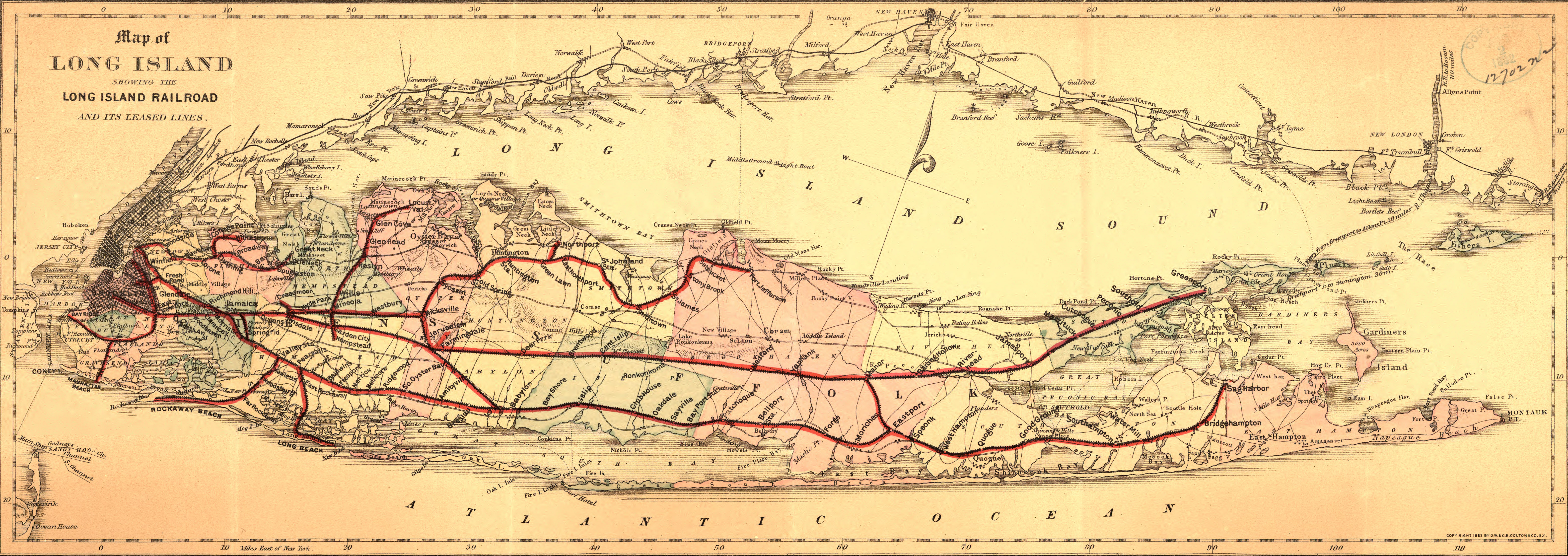
English: Map of Long Island showing the Long Island Railroad and its leased lines. Also shows drainage, cities and towns, township and county boundaries, and the railroad network. |
||
| Date | |||
| Source |
|
||
| Auteur | G.W. & C.B. Colton & Co. |

Conditions d’utilisation
Ce document est dans le domaine public aux États-Unis. Ceci s'applique aux travaux des États-Unis où le copyright a expiré, souvent parce que sa première publication s'est produite avant le 1er janvier 1929. Voir cette page pour davantage d'explication.
|
 | |
 |
Cette image peut ne pas être dans le domaine public en dehors des États-Unis (ceci s'applique particulièrement au Canada, en Chine (pas Hong Kong, Macao, ni Taïwan), en Allemagne ou en Suisse). Le créateur et l'année de la publication sont l'information essentielle et doivent être fournis.
|
Historique du fichier
Cliquer sur une date et heure pour voir le fichier tel qu'il était à ce moment-là.
| Date et heure | Vignette | Dimensions | Utilisateur | Commentaire | |
|---|---|---|---|---|---|
| actuel | 22 mai 2011 à 00:25 | 6 294 × 2 232 (4,15 Mio) | BurtAlert | {{Information |Description ={{en|1=Map of Long Island showing the Long Island Railroad and its leased lines. Also shows drainage, cities and towns, township and county boundaries, and the railroad network.}} |Source ={{LOC-map|id=g3802l.rr00447 |
Utilisation du fichier
La page suivante utilise ce fichier :
Usage global du fichier
Les autres wikis suivants utilisent ce fichier :
- Utilisation sur en.wikipedia.org