
Fichier:2011 flooding in Ayutthaya Province-EO-1 merged.jpg
Fichier d’origine (5 860 × 4 000 pixels, taille du fichier : 8,4 Mio, type MIME : image/jpeg)
Ce fichier et sa description proviennent de Wikimedia Commons.
Description
| Description |
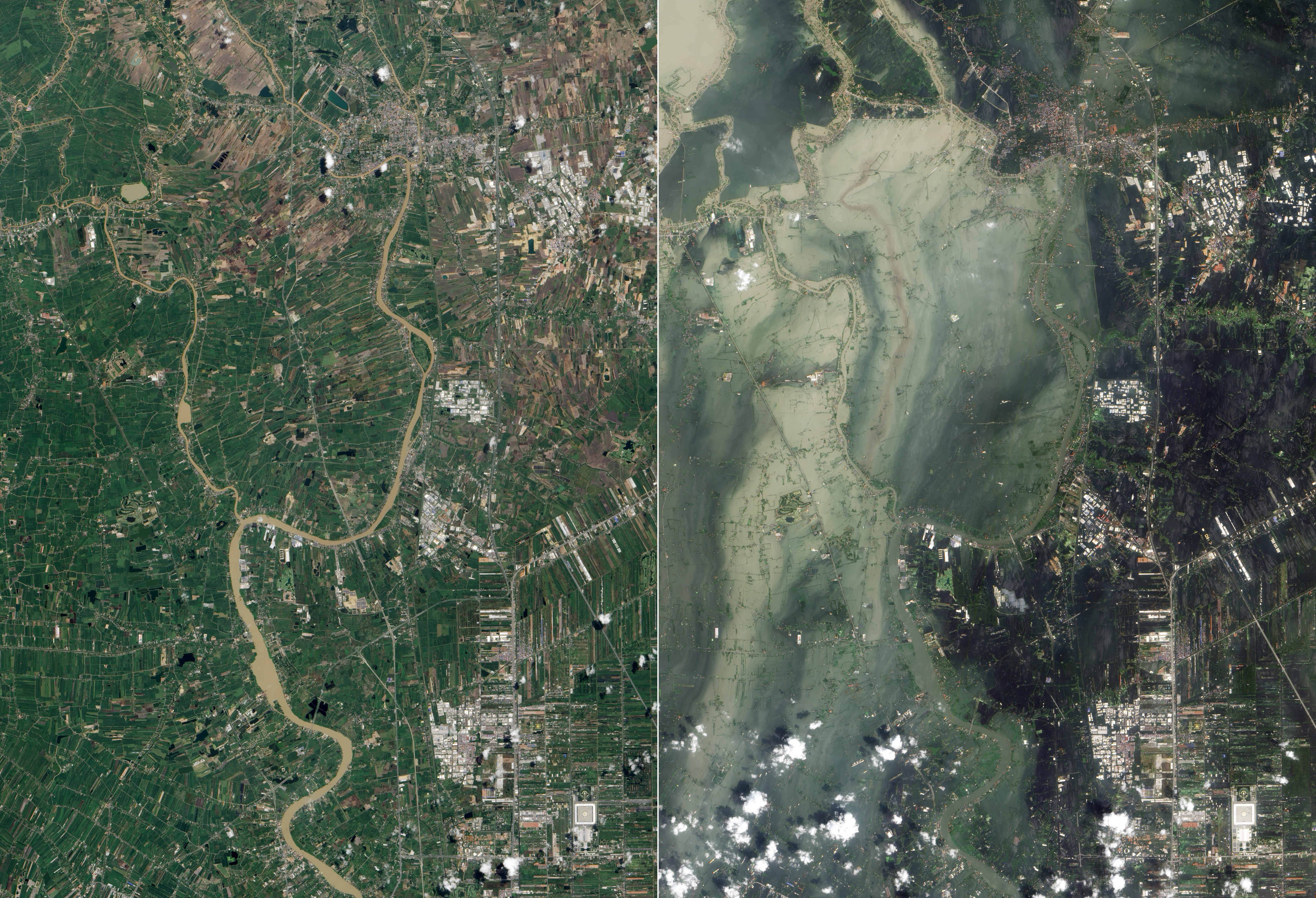
English: True-colour satellite image showing flooding in Ayutthaya and Pathum Thani Provinces in Central Thailand (right), compared to before the flooding (left).
Original caption: The Chao Phraya River forms at the confluence of smaller rivers in central Thailand, and flows southward to the Gulf of Thailand. En route to the sea, the river passes through Ayutthaya. First established in the fourteenth century, Ayutthaya lies north of Thailand’s capital city of Bangkok, and the floods plaguing Thailand in October 2011 did not spare this historic city. The Advanced Land Imager (ALI) on NASA’s Earth Observing-1 (EO-1) satellite acquired these natural-color images of Ayutthaya on October 23, 2011 ([right]), and July 11, 2011 (bottom). In both images, the Chao Phraya River curves through the southwestern part of the city (image lower left). In October, however, the river has overflowed onto nearby floodplains, especially southwest of the river and west of Route 356. Fields, roads, and buildings have all been submerged by sediment-clogged flood water. Thailand’s monsoon generally lasts from mid-May to September. Because these images show the region at different times of year, some of the differences in water and vegetation could result from normal seasonal variations. However, the large expanse of flood water in October 2011 is unusual even in a monsoon season. Flooding forced the closure of manufacturing plants in Ayutthaya, according to news reports. The city is a United Nations Educational, Scientific and Cultural Organization (UNESCO) World Heritage site. On October 12, UNESCO Bangkok announced a planned assessment of flood damage to Ayutthaya, requested by the government of Thailand. |
| Date | |
| Source | Nasa Earth Observatory |
| Auteur | NASA Earth Observatory image created by Jesse Allen and Robert Simmon, using EO-1 ALI data provided courtesy of the NASA EO-1 team and the United States Geological Survey. |
| Autres versions |
| Lieu de la prise de vue | | Voir cet endroit et d’autres images sur : OpenStreetMap |
|---|
|
Conditions d’utilisation
| Ce fichier provient de la NASA. Sauf exception, les documents créés par la NASA ne sont pas soumis à copyright. Pour plus d'informations, voir la politique de copyright de la NASA. | ||
 |
Attention :
|
Historique du fichier
Cliquer sur une date et heure pour voir le fichier tel qu'il était à ce moment-là.
| Date et heure | Vignette | Dimensions | Utilisateur | Commentaire | |
|---|---|---|---|---|---|
| actuel | 11 novembre 2011 à 08:53 | | 5 860 × 4 000 (8,4 Mio) | Paul 012 | =={{int:filedesc}}== {{Information |description={{en|1=True-colour satellite image showing flooding in Ayutthaya and Pathum Thani Provinces in Central Thailand (right), compared to before the flooding (left). Original caption: The Chao Phraya River forms |
Utilisation du fichier
La page suivante utilise ce fichier :
Usage global du fichier
Les autres wikis suivants utilisent ce fichier :
- Utilisation sur de.wikipedia.org
- Utilisation sur en.wikipedia.org
- Wikipedia:WikiProject Thailand
- Wikipedia:Featured pictures/Natural phenomena/Weather
- Conservation photography
- Wikipedia:WikiProject Thailand/Recognized content
- User talk:Paul 012/Archive 4
- Wikipedia:Featured pictures thumbs/29
- 2011 Thailand floods
- Talk:2011 Thailand floods
- Wikipedia:Featured picture candidates/November-2011
- Wikipedia:Featured picture candidates/2011 flooding in Ayutthaya, Thailand
- Wikipedia:Wikipedia Signpost/2011-11-28/Featured content
- User talk:Paul 012/Archive 5
- Wikipedia:Picture of the day/March 2013
- Template:POTD/2013-03-20
- Wikipedia:Main Page history/2013 March 20
- Wikipedia:Wikipedia Signpost/Single/2011-11-28
- Utilisation sur ms.wikipedia.org
- Utilisation sur uz.wikipedia.org
- Utilisation sur zh.wikipedia.org