
Fichier:Adriatic Charter Map.png
Pas de plus haute résolution disponible.
Adriatic_Charter_Map.png (606 × 570 pixels, taille du fichier : 19 kio, type MIME : image/png)
Ce fichier et sa description proviennent de Wikimedia Commons.
Description
| Description |
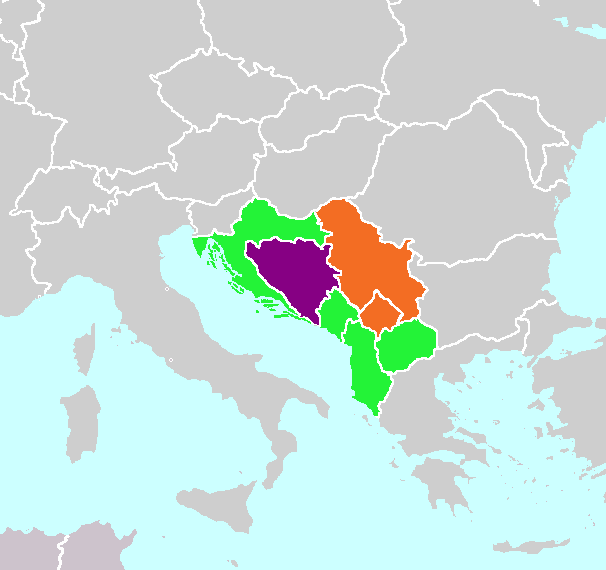
English: Green:Adriatic Charter Members in NATO (United States not shown), Purple:Adriatic Charter Members not in NATO, Orange:Observer States |
| Date | |
| Source | Travail personnel |
| Auteur | Avrand6 |
Conditions d’utilisation
Moi, en tant que détenteur des droits d’auteur sur cette œuvre, je la publie sous la licence suivante :
Ce fichier est sous la licence Creative Commons Attribution – Partage dans les Mêmes Conditions 4.0 International.
- Vous êtes libre :
- de partager – de copier, distribuer et transmettre cette œuvre
- d’adapter – de modifier cette œuvre
- Sous les conditions suivantes :
- paternité – Vous devez donner les informations appropriées concernant l'auteur, fournir un lien vers la licence et indiquer si des modifications ont été faites. Vous pouvez faire cela par tout moyen raisonnable, mais en aucune façon suggérant que l’auteur vous soutient ou approuve l’utilisation que vous en faites.
- partage à l’identique – Si vous modifiez, transformez, ou vous basez sur cette œuvre, vous devez distribuer votre contribution sous la même licence ou une licence compatible avec celle de l’original.
Historique du fichier
Cliquer sur une date et heure pour voir le fichier tel qu'il était à ce moment-là.
| Date et heure | Vignette | Dimensions | Utilisateur | Commentaire | |
|---|---|---|---|---|---|
| actuel | 28 mars 2020 à 17:42 | | 606 × 570 (19 kio) | Aleksamil | North Macedonia joined NATO on 27 March 2020 |
| 5 juin 2017 à 21:17 |  | 606 × 570 (22 kio) | Aleksamil | Reverted to version as of 19:16, 5 June 2017 (UTC) | |
| 5 juin 2017 à 21:17 |  | 606 × 570 (19 kio) | Aleksamil | Reverted to version as of 04:01, 13 September 2015 (UTC) | |
| 5 juin 2017 à 21:16 |  | 606 × 570 (22 kio) | Aleksamil | Montenegro joined NATO on 5 June 2017 | |
| 13 septembre 2015 à 06:01 |  | 606 × 570 (19 kio) | Avrand6 | User created page with UploadWizard |
Utilisation du fichier
La page suivante utilise ce fichier :
Usage global du fichier
Les autres wikis suivants utilisent ce fichier :
- Utilisation sur ar.wikipedia.org
- Utilisation sur bs.wikipedia.org
- Utilisation sur de.wiktionary.org
- Utilisation sur en.wikipedia.org
- Utilisation sur es.wikipedia.org
- Utilisation sur fa.wikipedia.org
- Utilisation sur hr.wikipedia.org
- Utilisation sur www.wikidata.org
- Utilisation sur zh.wikipedia.org