
Fichier:Ant-pen-map-Trinity-Peninsula.PNG
Taille de cet aperçu : 436 × 599 pixels. Autres résolutions : 175 × 240 pixels | 349 × 480 pixels | 720 × 989 pixels.
Fichier d’origine (720 × 989 pixels, taille du fichier : 255 kio, type MIME : image/png)
Ce fichier et sa description proviennent de Wikimedia Commons.
Description
| Description |
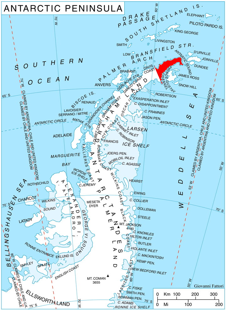
English: Location of Trinity Peninsula, Antarctica. |
| Date | |
| Source | Travail personnel, using map File:Ant-pen map.png by Giovanni Fattori. |
| Auteur | Edited by Apcbg |
Conditions d’utilisation
Moi, en tant que détenteur des droits d’auteur sur cette œuvre, je la publie sous les licences suivantes :
Ce fichier est disponible selon les termes de la licence Creative Commons Attribution – Partage dans les Mêmes Conditions 3.0 (non transposée).
- Vous êtes libre :
- de partager – de copier, distribuer et transmettre cette œuvre
- d’adapter – de modifier cette œuvre
- Sous les conditions suivantes :
- paternité – Vous devez donner les informations appropriées concernant l'auteur, fournir un lien vers la licence et indiquer si des modifications ont été faites. Vous pouvez faire cela par tout moyen raisonnable, mais en aucune façon suggérant que l’auteur vous soutient ou approuve l’utilisation que vous en faites.
- partage à l’identique – Si vous modifiez, transformez, ou vous basez sur cette œuvre, vous devez distribuer votre contribution sous la même licence ou une licence compatible avec celle de l’original.

|
Vous avez la permission de copier, distribuer et modifier ce document selon les termes de la GNU Free Documentation License version 1.2 ou toute version ultérieure publiée par la Free Software Foundation, sans sections inaltérables, sans texte de première page de couverture et sans texte de dernière page de couverture. Un exemplaire de la licence est inclus dans la section intitulée GNU Free Documentation License. |
Vous pouvez choisir l’une de ces licences.
Historique du fichier
Cliquer sur une date et heure pour voir le fichier tel qu'il était à ce moment-là.
| Date et heure | Vignette | Dimensions | Utilisateur | Commentaire | |
|---|---|---|---|---|---|
| actuel | 29 mars 2011 à 14:09 | | 720 × 989 (255 kio) | Apcbg | Updated per USGS definition. |
| 25 avril 2010 à 17:10 |  | 720 × 989 (255 kio) | Apcbg | {{Information |Description={{en|1=Location of Trinity Peninsula, Antarctica.}} |Source={{own}}, using map File:Ant-pen map.png by Giovanni Fattori. |Author=Edited by Apcbg |Date=2010-04-25 |Permission= |other_versions= }} [[Category:M |
Utilisation du fichier
Les 5 pages suivantes utilisent ce fichier :
Usage global du fichier
Les autres wikis suivants utilisent ce fichier :
- Utilisation sur ast.wikipedia.org
- Utilisation sur az.wikipedia.org
- Boil burnu
- Qarvan burnu
- Retije buxtası
- Çernopeyev zirvəsi
- Kribul təpəsi
- Draqor təpəsi
- Bardarevo təpəsi
- Qornik təpəsi
- Prilep təpəsi
- Konuş təpəsi
- Vişeqrad təpəsi
- Obzor təpəsi
- Giqen zirvəsi
- İqnatiyev dağı
- Sirius təpəsi
- Tintyava zirvəsi
- Lardiqo zirvəsi
- Oqled zirvəsi
- Çoçoveni nunatakı
- Smin zirvəsi
- Kolobar nunatakı
- Survakari nunatakı
- Mureno zirvəsi
- Draka nunatakı
- Smokinya buxtası
- Çudomir buxtası
- Senokos nunatakı
- Lopyan təpəsi
- Siniger nunatakı
- Koburq zirvəsi
- Obidim zirvəsi
- Zanoqe təpəsi
- Eremiya təpəsi
- Qreben təpəsi
- Yarlovo nunatakı
- Kumata təpəsi
- Utilisation sur bg.wikipedia.org
- Utilisation sur ceb.wikipedia.org
- Utilisation sur cs.wikipedia.org
Voir davantage sur l’utilisation globale de ce fichier.