
Fichier:Auroras over North America.jpg

Taille de cet aperçu : 600 × 600 pixels. Autres résolutions : 240 × 240 pixels | 480 × 480 pixels | 768 × 768 pixels | 1 024 × 1 024 pixels | 2 048 × 2 048 pixels | 3 677 × 3 677 pixels.
Fichier d’origine (3 677 × 3 677 pixels, taille du fichier : 2,05 Mio, type MIME : image/jpeg)
Ce fichier et sa description proviennent de Wikimedia Commons.
Description
| Description |
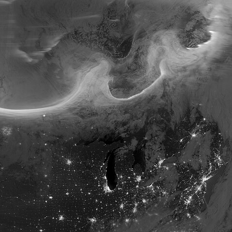
Deutsch: Bild der Aurora borealis vom frühen Morgen des 8. Oktobers 2012, aufgenommen mit dem "Tag-Nacht-Band" (DNB, 505 bis 890 Nanometer – hauptsächlich sichtbares Licht von grün bis nahem ultraviolett) der Visible Infrared Imaging Radiometer Suite (VIIRS) an Bord des Satelliten Suomi National Polar-orbiting Partnership (Suomi NPP). Die Lichter im Bild ziehen sich über die kanadischen Provinzen Quebec und Ontario und sind Teil des Gesamtovals, das sich durch einen geomagnetischen Sturm bis in mittlere Breiten hinab ausdehnte. English: Using the “day-night band” (DNB, 505 to 890 nanometres – primarily visible light from green to near visible infrared) of the Visible Infrared Imaging Radiometer Suite (VIIRS), the Suomi National Polar-orbiting Partnership (Suomi NPP) satellite acquired this view of the aurora borealis early on the morning of October 8, 2012. The northern lights stretch across Canada’s Quebec and Ontario provinces in the image, and are part of the auroral oval that expanded to middle latitudes because of a geomagnetic storm. |
| Date | |
| Source | NASA Earth Observatory |
| Auteur | Jesse Allen and Robert Simmon |
| Lieu de la prise de vue | | Voir cet endroit et d’autres images sur : OpenStreetMap |
|---|
| Annotations | Cette image est annotée : Voir les annotations sur Wikimedia Commons |
Conditions d’utilisation
| Ce fichier provient de la NASA. Sauf exception, les documents créés par la NASA ne sont pas soumis à copyright. Pour plus d'informations, voir la politique de copyright de la NASA. | ||
 |
Attention :
|
Historique du fichier
Cliquer sur une date et heure pour voir le fichier tel qu'il était à ce moment-là.
| Date et heure | Vignette | Dimensions | Utilisateur | Commentaire | |
|---|---|---|---|---|---|
| actuel | 12 octobre 2012 à 12:00 | | 3 677 × 3 677 (2,05 Mio) | Originalwana | {{Information |Description ={{en|1=Using the “day-night band” (DNB) of the Visible Infrared Imaging Radiometer Suite (VIIRS), the Suomi National Polar-orbiting Partnership (Suomi NPP) satellite acquired this view of the aurora borealis early on ... |
Utilisation du fichier
La page suivante utilise ce fichier :
Usage global du fichier
Les autres wikis suivants utilisent ce fichier :
- Utilisation sur et.wikipedia.org
- Utilisation sur id.wikipedia.org
- Utilisation sur sk.wikipedia.org
- Utilisation sur zh.wikipedia.org