
Fichier:Celtic Sea and Bay of Biscay bathymetric map-fr.svg

Taille de cet aperçu PNG pour ce fichier SVG : 548 × 599 pixels. Autres résolutions : 219 × 240 pixels | 439 × 480 pixels | 702 × 768 pixels | 936 × 1 024 pixels | 1 872 × 2 048 pixels | 3 478 × 3 804 pixels.
Fichier d’origine (Fichier SVG, nominalement de 3 478 × 3 804 pixels, taille : 4,93 Mio)
Ce fichier et sa description proviennent de Wikimedia Commons.
Description
| Description |
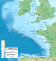
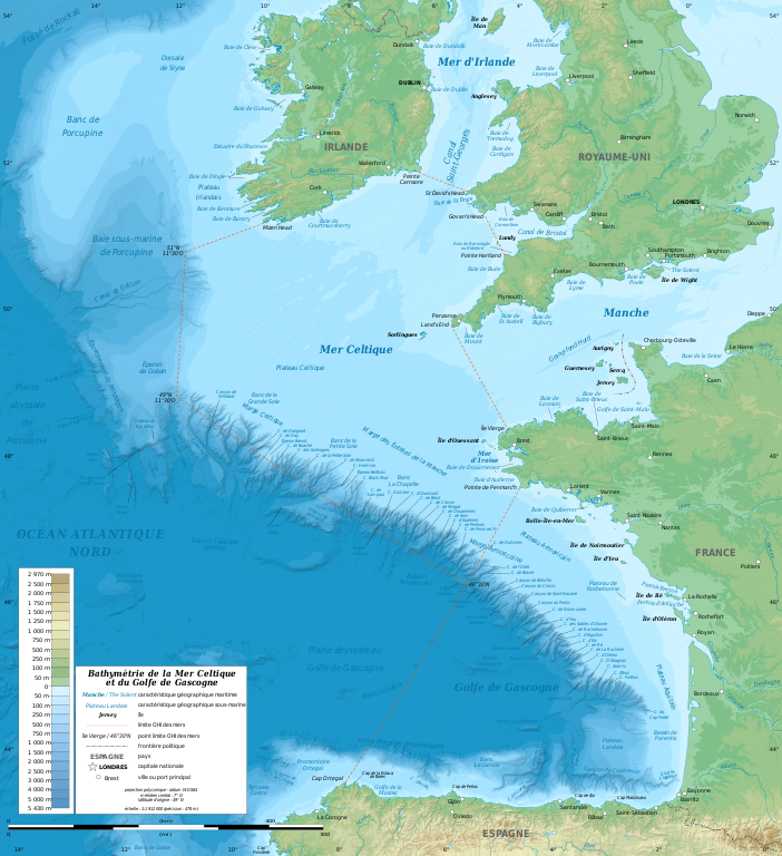
English: Bathymetric map in French of the Celtic Sea and the Bay of Biscay. Limits of the seas as specified by the International Hydrographic Organization.
Note: the background map is a raster image embedded in the SVG file. Français : Carte bathymétrique en français de la Mer Celtique et du Golfe de Gascogne. Limites des mers telles que définies par l'Organisation Hydrographique Internationale. Note : le fond de carte est une image bitmap embarquée dans le fichier SVG.
|
||
| Date | janvier 2011, upgraded 2019-10 | ||
| Source |
Travail personnel
|
||
| Auteur | Eric Gaba (Sting - fr:Sting) | ||
| Autorisation (Réutilisation de ce fichier) |
|
||
| Autres versions |
[]
|
||
| SVG information | Le code de ce grand fichier SVG n'est pas valide en raison d'une erreur. Cette carte SVG utilise du texte encapsulé qui peut être traduit facilement à l'aide d'un éditeur de texte. |


| Lieu de la prise de vue | | Voir cet endroit et d’autres images sur : OpenStreetMap |
|---|
Conditions d’utilisation
Eric Gaba (Wikimedia Commons user Sting), en tant que détenteur des droits d’auteur sur cette œuvre, la publie sous la licence suivante :
Ce fichier est disponible selon les termes de la licence Creative Commons Attribution – Partage dans les Mêmes Conditions 3.0 (non transposée).
Attribution: Eric Gaba (Wikimedia Commons user Sting)
- Vous êtes libre :
- de partager – de copier, distribuer et transmettre cette œuvre
- d’adapter – de modifier cette œuvre
- Sous les conditions suivantes :
- paternité – Vous devez donner les informations appropriées concernant l'auteur, fournir un lien vers la licence et indiquer si des modifications ont été faites. Vous pouvez faire cela par tout moyen raisonnable, mais en aucune façon suggérant que l’auteur vous soutient ou approuve l’utilisation que vous en faites.
- partage à l’identique – Si vous modifiez, transformez, ou vous basez sur cette œuvre, vous devez distribuer votre contribution sous la même licence ou une licence compatible avec celle de l’original.
Historique du fichier
Cliquer sur une date et heure pour voir le fichier tel qu'il était à ce moment-là.
| Date et heure | Vignette | Dimensions | Utilisateur | Commentaire | |
|---|---|---|---|---|---|
| actuel | 4 novembre 2019 à 15:11 | | 3 478 × 3 804 (4,93 Mio) | Sting | Correction of a name |
| 28 octobre 2019 à 22:56 |  | 3 478 × 3 804 (4,92 Mio) | Sting | New map using GEBCO 15 Sec topographic data ; rivers from ECRINS ; added names | |
| 24 janvier 2011 à 20:15 |  | 1 749 × 1 913 (613 kio) | Sting | A few more names | |
| 23 janvier 2011 à 18:54 |  | 1 749 × 1 913 (610 kio) | Sting | Added maritim features names | |
| 23 janvier 2011 à 05:26 |  | 1 749 × 1 913 (559 kio) | Sting | == {{int:filedesc}} == {{Information |Description={{en|Bathymetric map in French of the Celtic Sea and the Bay of Biscay.<br/> ''Note: the background map is a raster image embedded in the SVG file.''}} {{fr|Carte b |
Utilisation du fichier
Les 9 pages suivantes utilisent ce fichier :
Usage global du fichier
Les autres wikis suivants utilisent ce fichier :
- Utilisation sur ar.wikipedia.org
- Utilisation sur bs.wikipedia.org
- Utilisation sur cs.wikipedia.org
- Utilisation sur de.wikipedia.org
- Utilisation sur eo.wikipedia.org
- Utilisation sur gv.wikipedia.org
- Utilisation sur hr.wikipedia.org
- Utilisation sur mr.wikipedia.org
- Utilisation sur oc.wikipedia.org
- Utilisation sur pl.wiktionary.org
- Utilisation sur sh.wikipedia.org
- Utilisation sur sr.wikipedia.org
- Utilisation sur sv.wikipedia.org
- Utilisation sur ta.wikipedia.org
- Utilisation sur th.wikipedia.org
- Utilisation sur ur.wikipedia.org
- Utilisation sur www.wikidata.org