
Fichier:Doaks-Stand.png

Taille de cet aperçu : 794 × 599 pixels. Autres résolutions : 318 × 240 pixels | 636 × 480 pixels | 1 018 × 768 pixels | 1 280 × 966 pixels | 2 272 × 1 715 pixels.
Fichier d’origine (2 272 × 1 715 pixels, taille du fichier : 40 kio, type MIME : image/png)
Ce fichier et sa description proviennent de Wikimedia Commons.
Description
| Description |
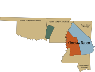
English: Map of U.S. states Arkansas, Mississippi, and Oklahoma in relation to Choctaw land ceded to the U.S. According to the Treaty of Doak's Stand (1820) the area in orange was ceded to the United States, and the area in green was ceded to the Choctaw nation. |
| Date | |
| Source | Travail personnel |
| Auteur | Rob (talk) |
Conditions d’utilisation
| Moi, propriétaire des droits d’auteur sur cette œuvre, la place dans le domaine public. Ceci s'applique dans le monde entier. Dans certains pays, ceci peut ne pas être possible ; dans ce cas : J’accorde à toute personne le droit d’utiliser cette œuvre dans n’importe quel but, sans aucune condition, sauf celles requises par la loi. |
Historique du fichier
Cliquer sur une date et heure pour voir le fichier tel qu'il était à ce moment-là.
| Date et heure | Vignette | Dimensions | Utilisateur | Commentaire | |
|---|---|---|---|---|---|
| actuel | 24 avril 2008 à 22:48 | | 2 272 × 1 715 (40 kio) | Robfergusonjr | Author: Rob Ferguson. |
| 18 avril 2008 à 15:54 |  | 811 × 1 218 (20 kio) | Robfergusonjr | ||
| 18 avril 2008 à 15:51 |  | 811 × 1 218 (20 kio) | Robfergusonjr | {{Information |Description=Map of U.S. state Mississippi in realation to Choctaw land ceded to the U.S. according to the Treaty of Doak's Stand (1820). |Source=self-made |Date=April 18, 2008 |Author=~~~ |other_versions= }} |
Utilisation du fichier
La page suivante utilise ce fichier :
Usage global du fichier
Les autres wikis suivants utilisent ce fichier :
- Utilisation sur en.wikipedia.org