
Fichier:Europe 1783-1792 en.png

Taille de cet aperçu : 800 × 570 pixels. Autres résolutions : 320 × 228 pixels | 640 × 456 pixels | 1 024 × 730 pixels | 1 280 × 913 pixels | 2 560 × 1 825 pixels | 3 872 × 2 761 pixels.
Fichier d’origine (3 872 × 2 761 pixels, taille du fichier : 1,24 Mio, type MIME : image/png)
Ce fichier et sa description proviennent de Wikimedia Commons.
_en.png)
.png)
.jpg)
Description
| Description |
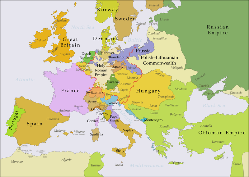
English: This map shows Europe in the years between the 1783 Russian annexation of Crimea after the Russo-Turkish War of 1768–1774 and the Russian annexation of Yedisan in 1792 at the end of the Russo-Turkish War of 1787–1792. The red line marks the borders of the Holy Roman Empire. The work was created with Inkscape and is mainly based on a map in: Putzger - Historischer Weltatlas, Berlin 1990, 78 pp. |
| Date | |
| Source | Travail personnel, based on File:Europe 1748-1766 en.png |
| Auteur | Bryan Rutherford |
Conditions d’utilisation
Moi, en tant que détenteur des droits d’auteur sur cette œuvre, je la publie sous la licence suivante :
Ce fichier est sous la licence Creative Commons Attribution – Partage dans les Mêmes Conditions 4.0 International.
- Vous êtes libre :
- de partager – de copier, distribuer et transmettre cette œuvre
- d’adapter – de modifier cette œuvre
- Sous les conditions suivantes :
- paternité – Vous devez donner les informations appropriées concernant l'auteur, fournir un lien vers la licence et indiquer si des modifications ont été faites. Vous pouvez faire cela par tout moyen raisonnable, mais en aucune façon suggérant que l’auteur vous soutient ou approuve l’utilisation que vous en faites.
- partage à l’identique – Si vous modifiez, transformez, ou vous basez sur cette œuvre, vous devez distribuer votre contribution sous la même licence ou une licence compatible avec celle de l’original.
| Annotations | Cette image est annotée : Voir les annotations sur Wikimedia Commons |
Historique du fichier
Cliquer sur une date et heure pour voir le fichier tel qu'il était à ce moment-là.
| Date et heure | Vignette | Dimensions | Utilisateur | Commentaire | |
|---|---|---|---|---|---|
| actuel | 15 juillet 2018 à 23:47 | | 3 872 × 2 761 (1,24 Mio) | Bryanrutherford0 | Added the Ionian Islands, made the Duchy of Milan a Habsburg possession, gave Prussia control of Mansfeld (1780) |
| 10 juillet 2018 à 04:29 |  | 3 872 × 2 761 (1,23 Mio) | Bryanrutherford0 | Added Comtat Venaissin and redrew borders of Neuchâtel, Bishopric Basel, and Montbéliard | |
| 3 octobre 2017 à 02:46 |  | 3 872 × 2 761 (1,23 Mio) | Bryanrutherford0 | Transferred control of Saaremaa and Hiiumaa to Russia (1721 Treaty of Nystad), transferred control of Corsica to France (1769 [[:en:French conquest of Corsica|French conquest of... | |
| 30 septembre 2017 à 17:03 |  | 3 872 × 2 761 (1,23 Mio) | Bryanrutherford0 | Adjusted Russian-Swedish border in Finland to reflect Russian gains in the 1743 Treaty of Åbo after the Russo-Swedish War. | |
| 30 septembre 2017 à 06:47 |  | 3 872 × 2 761 (1,23 Mio) | Bryanrutherford0 | User created page with UploadWizard |
Utilisation du fichier
La page suivante utilise ce fichier :
Usage global du fichier
Les autres wikis suivants utilisent ce fichier :
- Utilisation sur ar.wikipedia.org
- Utilisation sur bg.wikipedia.org
- Utilisation sur bn.wikipedia.org
- Utilisation sur br.wikipedia.org
- Utilisation sur ca.wikipedia.org
- Utilisation sur el.wikipedia.org
- Utilisation sur en.wikipedia.org
- Utilisation sur es.wikipedia.org
- Utilisation sur fi.wikipedia.org
- Utilisation sur it.wikipedia.org
- Utilisation sur ja.wikipedia.org
- Utilisation sur ka.wikipedia.org
- Utilisation sur mk.wikipedia.org
- Utilisation sur sl.wikipedia.org
- Utilisation sur th.wikipedia.org
- Utilisation sur tl.wikipedia.org
- Utilisation sur uz.wikipedia.org
- Utilisation sur vi.wikipedia.org
- Utilisation sur zh.wikipedia.org