
Fichier:FHWA Auxiliary Route Numbering Diagram.svg

Taille de cet aperçu PNG pour ce fichier SVG : 800 × 320 pixels. Autres résolutions : 320 × 128 pixels | 640 × 256 pixels | 1 024 × 410 pixels | 1 280 × 512 pixels | 2 560 × 1 024 pixels | 1 000 × 400 pixels.
Fichier d’origine (Fichier SVG, nominalement de 1 000 × 400 pixels, taille : 127 kio)
Ce fichier et sa description proviennent de Wikimedia Commons.
Description
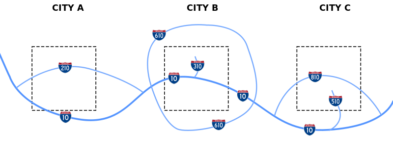
| Description | Diagram of how the FHWA assigns numbers to different types of interstate routes |
| Date | |
| Source | Travail personnel |
| Auteur | Stratosphere |
| Autorisation (Réutilisation de ce fichier) |
Public Domain |
Conditions d’utilisation
Moi, en tant que détenteur des droits d’auteur sur cette œuvre, je la publie sous la licence suivante :
| Ce fichier est disponible selon les termes de la licence Creative Commons CC0 Don universel au domaine public. | |
| La personne qui a associé une œuvre avec cet acte l’a placée dans le domaine public en renonçant mondialement à tous ses droits sur cette œuvre en vertu des lois relatives au droit d’auteur, ainsi qu’à tous les droits juridiques connexes et voisins qu’elle possédait sur l’œuvre, sans autre limite que celles imposées par la loi. Vous pouvez copier, modifier, distribuer et utiliser cette œuvre, y compris à des fins commerciales, sans qu’il soit nécessaire d’en demander la permission.
|
Historique du fichier
Cliquer sur une date et heure pour voir le fichier tel qu'il était à ce moment-là.
| Date et heure | Vignette | Dimensions | Utilisateur | Commentaire | |
|---|---|---|---|---|---|
| actuel | 18 février 2008 à 11:56 | 1 000 × 400 (127 kio) | Stratosphere | ||
| 18 février 2008 à 11:53 | 1 000 × 400 (21 kio) | Stratosphere | |||
| 18 février 2008 à 11:47 | 1 000 × 400 (8 kio) | Stratosphere | |||
| 18 février 2008 à 11:43 | 1 000 × 400 (7 kio) | Stratosphere | |||
| 18 février 2008 à 11:41 | 1 000 × 400 (10 kio) | Stratosphere | {{Information |Description=Diagram of how the FHWA assigns numbers to different types of interstate routes |Source=self-made |Date=February 18, 2008 |Author= Stratosphere |Permission=Public Domain |other_versions= }} |
Utilisation du fichier
La page suivante utilise ce fichier :
Usage global du fichier
Les autres wikis suivants utilisent ce fichier :
- Utilisation sur en.wikipedia.org
- Utilisation sur es.wikipedia.org
- Utilisation sur he.wikipedia.org
- Utilisation sur it.wikipedia.org
- Utilisation sur pt.wikipedia.org
- Utilisation sur ru.wikipedia.org
- Utilisation sur uk.wikipedia.org
- Utilisation sur vi.wikipedia.org
- Utilisation sur zh.wikipedia.org