
Fichier:Frozen Franz Josef Land - NASA Earth Observatory.jpg
Fichier d’origine (720 × 720 pixels, taille du fichier : 183 kio, type MIME : image/jpeg)
Ce fichier et sa description proviennent de Wikimedia Commons.
Description
| Description |
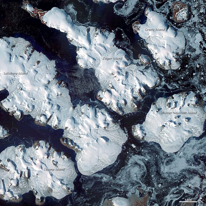
To download the full resolution and other files go to: earthobservatory.nasa.gov/IOTD/view.php?id=76883&src=... Located just 600 miles (970 kilometers) from the North Pole, Franz Josef Land is perpetually coated with ice. Glaciers cover roughly 85 percent of the archipelago’s land masses, and sea ice floats in the channels between islands even in the summertime. The Advanced Spaceborne Thermal Emission and Reflection Radiometer (ASTER) on NASA’s Terra satellite observed the islands of central Franz Josef Land on August 16 and 19, 2011. (Another sensor on Terra captured a wider view on August 17, 2011.) The image above was made from a combination of visible and near-infrared wavelengths, and ice appears in shades of white and pale blue. The amount of sea ice filling the channels between the islands of Franz Josef Land varies from summer to summer. Captured toward the end of the Northern Hemisphere melt season, this shot shows a modest amount of sea ice on the ocean surface. Some of the ice has accumulated in bays like the one near northeastern Zieger Island. Most of the ice in this scene is anchored to land, as large glaciers blanket the islands. Yet today’s glaciers are tiny compared to the ice sheet that dominated the region about 20,000 years ago. Studies of Franz Josef Land have actually contributed to a larger understanding of when that massive ice sheet began its slow retreat. Raised beaches, which preserve evidence of land rising as the crushing weight of overlying glaciers eases (known as isostatic rebound), were first recognized on the islands in the late nineteenth century. Researchers estimate that the giant ice sheet had retreated by about 10,000 years ago. NASA image created by Jesse Allen, using data provided courtesy of NASA/GSFC/METI/ERSDAC/JAROS, and U.S./Japan ASTER Science Team. Caption by Michon Scott with information from Walt Meier and Ted Scambos, National Snow and Ice Data Center. The Earth Observatory's mission is to share with the public the images, stories, and discoveries about climate and the environment that emerge from NASA research, including its satellite missions, in-the-field research, and climate models. Like us on Facebook Follow us on Twitter Add us to your circles on Google+ |
| Date | |
| Source | Frozen Franz Josef Land |
| Auteur | NASA's Earth Observatory |
| Lieu de la prise de vue | | Voir cet endroit et d’autres images sur : OpenStreetMap |
|---|
Conditions d’utilisation
- Vous êtes libre :
- de partager – de copier, distribuer et transmettre cette œuvre
- d’adapter – de modifier cette œuvre
- Sous les conditions suivantes :
- paternité – Vous devez donner les informations appropriées concernant l'auteur, fournir un lien vers la licence et indiquer si des modifications ont été faites. Vous pouvez faire cela par tout moyen raisonnable, mais en aucune façon suggérant que l’auteur vous soutient ou approuve l’utilisation que vous en faites.
| Cette image a été originellement postée sur Flickr par NASA Earth Observatory à l'adresse https://www.flickr.com/photos/68824346@N02/6653043801. Elle a été passée en revue le 2 juillet 2012 par le robot FlickreviewR, qui a confirmé qu'elle se trouvait sous licence cc-by-2.0. |
Historique du fichier
Cliquer sur une date et heure pour voir le fichier tel qu'il était à ce moment-là.
| Date et heure | Vignette | Dimensions | Utilisateur | Commentaire | |
|---|---|---|---|---|---|
| actuel | 2 juillet 2012 à 19:14 | | 720 × 720 (183 kio) | Dzlinker | == {{int:filedesc}} == {{Information |Description=To download the full resolution and other files go to: [http://earthobservatory.nasa.gov/IOTD/view.php?id=76883&src=flickr earthobservatory.nasa.gov/IOTD/view.php?id=76883&src=...] Located just 600 mil... |
Utilisation du fichier
Les 5 pages suivantes utilisent ce fichier :
Usage global du fichier
Les autres wikis suivants utilisent ce fichier :
- Utilisation sur ast.wikipedia.org
- Utilisation sur avk.wikipedia.org
- Utilisation sur cs.wikipedia.org
- Utilisation sur de.wikipedia.org
- Utilisation sur en.wikipedia.org
- Utilisation sur gl.wikipedia.org
- Utilisation sur ja.wikipedia.org
- Utilisation sur nn.wikipedia.org
- Utilisation sur no.wikipedia.org
- Utilisation sur pl.wikipedia.org
- Utilisation sur pt.wikipedia.org
- Utilisation sur ro.wikipedia.org