
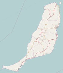
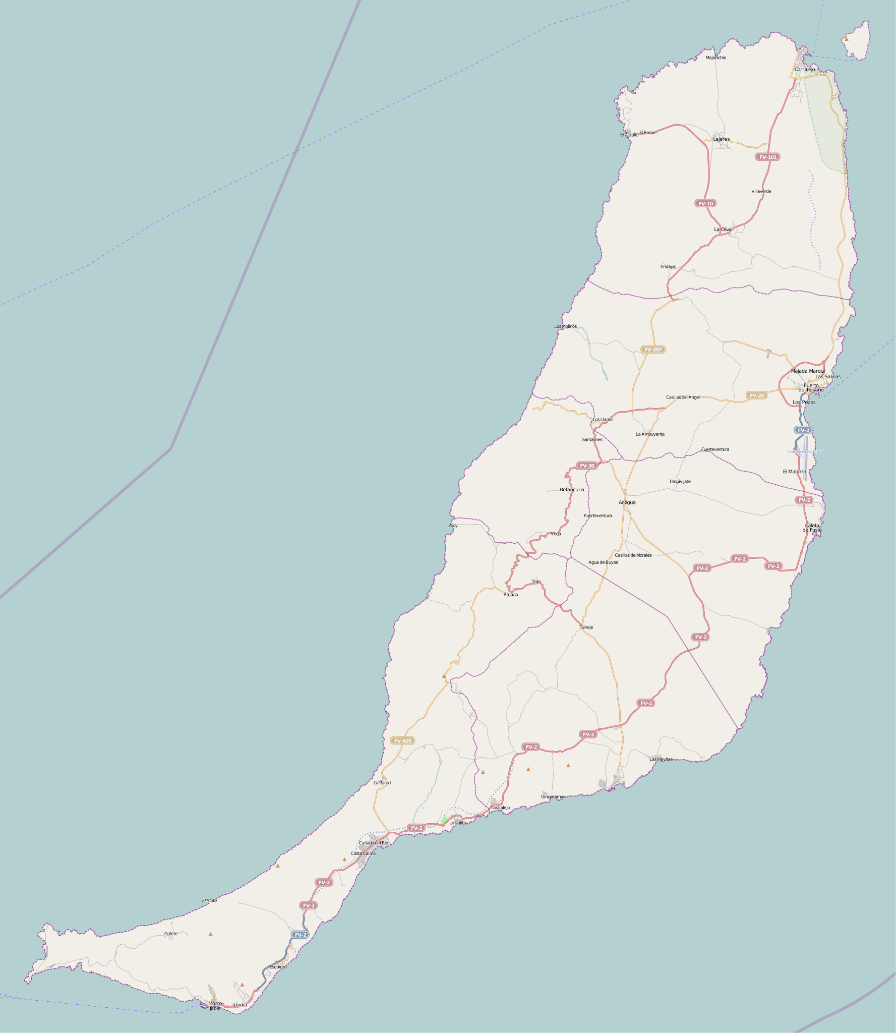
Fichier:Fuerteventura (Canary Islands) - OSM Mapnik.svg

Taille de cet aperçu PNG pour ce fichier SVG : 520 × 599 pixels. Autres résolutions : 208 × 240 pixels | 416 × 480 pixels | 666 × 768 pixels | 889 × 1 024 pixels | 1 777 × 2 048 pixels | 2 298 × 2 648 pixels.
Fichier d’origine (Fichier SVG, nominalement de 2 298 × 2 648 pixels, taille : 2,01 Mio)
Ce fichier et sa description proviennent de Wikimedia Commons.
_-_OSM_Mapnik.svg?uselang=fr)
| Description |
Cette carte a été créée à partir des données du projet OpenStreetMap. Cette carte est peut-être incomplète et peut contenir des erreurs. Ne vous fiez pas uniquement à elle pour vos déplacements. |
| Date | (voir l'historique du fichier) |
| Source | openstreetmap.org |
| Créé par |
contributeurs d'OpenStreetMap |
| Autorisation (Réutilisation de ce fichier) |
Les données et cartes d'OpenStreetMap sont publiées sous licence Creative Commons Attribution-ShareAlike 2.0 license (CC-BY-SA 2.0). Ce fichier est disponible selon les termes de la licence Creative Commons Attribution – Partage dans les Mêmes Conditions 2.0 Générique
|
| Géoréférencement | Si c'est inapproprié, définissez warp_status = skip pour masquer. |
Historique du fichier
Cliquer sur une date et heure pour voir le fichier tel qu'il était à ce moment-là.
| Date et heure | Vignette | Dimensions | Utilisateur | Commentaire | |
|---|---|---|---|---|---|
| actuel | 25 novembre 2010 à 15:49 | | 2 298 × 2 648 (2,01 Mio) | Muro de Aguas | updating |
| 2 juillet 2010 à 16:25 |  | 2 298 × 2 648 (1,9 Mio) | Muro de Aguas | updating | |
| 16 avril 2010 à 19:10 |  | 2 298 × 2 648 (1,89 Mio) | Muro de Aguas | updating | |
| 27 février 2010 à 19:18 |  | 2 298 × 2 648 (1,89 Mio) | Muro de Aguas | {{OpenStreetMap|name=Fuerteventura|source=http://www.openstreetmap.org/?lat=28.4165&lon=-14.1515&zoom=10&layers=B000FTFTT}} Category:OpenStreetMap maps of the Canary Islands Category:Maps of Fuerteventura Category:Maps of the Canary Islands |
Utilisation du fichier
Les 28 pages suivantes utilisent ce fichier :
- Agua de Bueyes
- Antigua (Fuerteventura)
- Betancuria
- Caleta de Fuste
- Cofete
- Corralejo
- Costa Calma
- Gran Tarajal
- La Oliva
- Mont Tindaya
- Morro Jable
- Parc naturel de Corralejo
- Parc naturel de Jandía
- Phare de Morro Jable
- Phare de Puerto del Rosario
- Phare de Punta Jandía
- Phare de Punta La Entallada
- Phare de Punta Martiño
- Phare de Tostón
- Pic de la Zarza
- Puerto del Rosario
- Pájara
- Péninsule de Jandía
- Stade municipal de Los Pozos
- Tuineje
- Wikipédia:Atelier graphique/Cartes/Archives/juin 2015
- Wikipédia:Atelier modèle de géolocalisation/Archives/2015
- Modèle:Géolocalisation/Fuerteventura
Usage global du fichier
Les autres wikis suivants utilisent ce fichier :
- Utilisation sur ar.wikipedia.org
- Utilisation sur ast.wikipedia.org
- Utilisation sur en.wikipedia.org
- Puerto del Rosario
- Fuerteventura Airport
- Tostón Lighthouse
- Punta La Entallada Lighthouse
- Morro Jable Lighthouse
- Punta Jandía Lighthouse
- Punta Martiño Lighthouse
- Module:Location map/data/Spain Fuerteventura
- Module:Location map/data/Spain Fuerteventura/doc
- Puerto del Rosario Lighthouse
- Template:Lighthouses of the Canary Islands map
- Utilisation sur es.wikipedia.org
- Playa del Matorral
- Faro de Morro Jable
- Faro de Punta La Entallada
- Hornos de cal de la Guirra
- Montaña de Tindaya
- Ajuy
- Playa de la Goleta (Corralejo)
- Cofete
- Castillo de El Cotillo
- El Cotillo
- Faro del Puerto del Rosario
- Faro de Punta Jandía
- Faro Tostón
- Faro de Punta Martiño
- Castillo de Fuste
- Lajares (La Oliva)
- Plantilla:Mapa de localización de Fuerteventura
- Casillas del Ángel
- Tetir
- El Matorral (Fuerteventura)
- Tarajalejo
- Utilisation sur hu.wikipedia.org
- Utilisation sur ja.wikipedia.org
- Utilisation sur nl.wikipedia.org
- Utilisation sur si.wikipedia.org
- Utilisation sur sl.wikipedia.org
Voir davantage sur l’utilisation globale de ce fichier.
_-_OSM_Mapnik.svg)
_-_OSM_Mapnik.svg)