
Fichier:Hellenism in the Near East 1918.jpg
Taille de cet aperçu : 489 × 600 pixels. Autres résolutions : 196 × 240 pixels | 391 × 480 pixels | 626 × 768 pixels | 835 × 1 024 pixels | 1 403 × 1 721 pixels.
Fichier d’origine (1 403 × 1 721 pixels, taille du fichier : 862 kio, type MIME : image/jpeg)
Ce fichier et sa description proviennent de Wikimedia Commons.
Description
| Description |
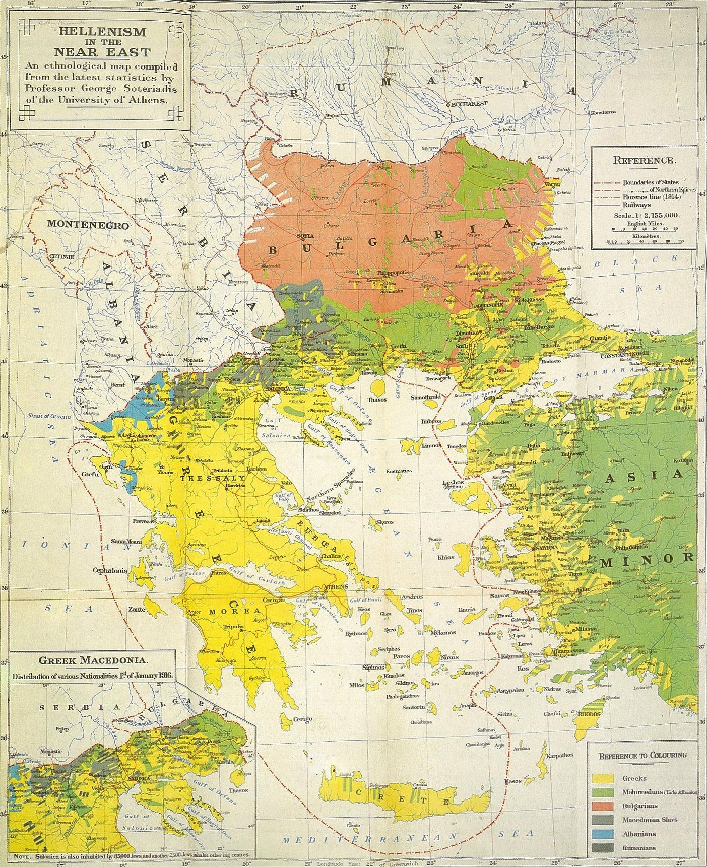
العربية: المملكة اليونانية وانتشار اليونان في البلقان وغربي آسيا الصغرى وفقًا لخريطة من عام 1919 قدمها المفوضين اليونان إلى مؤتمر السلام في باريس.
English: "...The present map, on the other hand, takes not language, but national conciousness as the only satisfactory criterion of nationality..." - The original, detailed explanation from the publisher of the map is exposed here. Important factor: the map shows the population, as it was before the 1923-1930 population exchange processs, and before migrations caused by the Greek civil war. The map recognizes the "Macedonian Slavs" nationality, as a separate one, non-Bulgarian.
Polski: Niniejsza mapa nie przedstawia zasięgu używanych języków, a koncentruje się na samookreśleniu świadomości narodowej, stwierdzonej w poszczególnych grupach ludności. I tak np. autor do Greków zaliczył Wlachów (lokalne określenie greckich Arumunów), podczas gdy mówiących podobnym językiem Kucowołochów, nie uważających się za Greków, autor zaliczył do narodowości rumuńskiej. Podobnie geckich Arwanitów z Attyki czy Peloponezu zaliczono do narodowości greckiej - mimo języka zbliżonego do albańskiego, należeli oni, już od wielkiego powstania 1821, do najbardziej państwotwórczych czynników nowożytnej Grecji. Podczas gdy Czamów autor zaliczył do narodowości Albańskiej, z uwagi na takie ich samookreślanie się. Mapa dokumentuje też istnienie poczucia odrębności narodowej "Macedońskich Słowian", odróżniając ich od "Bułgarów". Oryginalne, szczegółowe wyjaśnienia od wydawcy mapy, czytelnik znajdzie tutaj |
| Source | “An Ethnological Map Illustrating Hellenism In The Balkan Peninsula And Asia Minor” |
| Auteur | George Soteriadis, 1852-1942, Professor of History at the University of Athens |
| Autorisation (Réutilisation de ce fichier) |
"London: Edward Stanford, LTD. 12, 13, 14 Long Acre, W.C.2. 1918" |
Conditions d’utilisation
|
L’auteur est mort en 1942 ; cette œuvre est donc également dans le domaine public dans tous les pays pour lesquels le droit d’auteur a une durée de vie de 80 ans ou moins après la mort de l’auteur. Cette œuvre est dans le domaine public aux États-Unis car elle a été publiée avant le 1er janvier 1929. | |
| Ce fichier a été identifié comme étant exempt de restrictions connues liées au droit d’auteur, y compris tous les droits connexes et voisins. | |
Journal des téléversements d’origine
La page de description originale était ici. Tous les noms d'utilisateur qui suivent se rapportent à en.wikipedia.
- 2010-04-05 17:54 Beao 1403×1721× (882530 bytes)
- 2008-05-18 22:18 Mactruth 1444×1749× (757962 bytes) Author: George Soteriadis Professor of History at the University of Athens Book Title: “An Ethnological Map Illustrating Hellenism In The Balkan Peninsula And Asia Minor” Source/Copyright: "London: Edward Stanford, LTD. 12, 13, 14 Long Acre, W.C.2. 1
Historique du fichier
Cliquer sur une date et heure pour voir le fichier tel qu'il était à ce moment-là.
| Date et heure | Vignette | Dimensions | Utilisateur | Commentaire | |
|---|---|---|---|---|---|
| actuel | 17 novembre 2011 à 03:33 | | 1 403 × 1 721 (862 kio) | OgreBot | (BOT): Reverting to most recent version before archival |
| 17 novembre 2011 à 03:33 |  | 1 444 × 1 749 (740 kio) | OgreBot | (BOT): Uploading old version of file from en.wikipedia; originally uploaded on 2008-05-18 22:18:46 by Mactruth | |
| 30 mars 2011 à 09:43 |  | 1 403 × 1 721 (862 kio) | Khutuck Bot | {{BotMoveToCommons|tr.wikipedia|year={{subst:CURRENTYEAR}}|month={{subst:CURRENTMONTHNAME}}|day={{subst:CURRENTDAY}}}} {{Information |Description={{tr|== Lisanslama ==}} |Source=Transferred from [http://tr.wikipedia.org tr.wikipedia] |Date={{Date|2010|0 | |
| 20 mars 2008 à 11:26 |  | 1 444 × 1 749 (740 kio) | JulienMarque | {{Information |Description=Hellenism in the Near East |Source="An Ethnological Map Illustrating Hellenism in the Balkan Peninsula and Asia Minor", Edward Stanford, London |Date=1918 |Author=George Soteriadis |Permission={{PD-old}} }} |
Utilisation du fichier
La page suivante utilise ce fichier :
Usage global du fichier
Les autres wikis suivants utilisent ce fichier :
- Utilisation sur ar.wikipedia.org
- Utilisation sur azb.wikipedia.org
- Utilisation sur be.wikipedia.org
- Utilisation sur bg.wikipedia.org
- Utilisation sur ca.wikipedia.org
- Utilisation sur cs.wikipedia.org
- Utilisation sur de.wikipedia.org
- Utilisation sur el.wikipedia.org
- Utilisation sur en.wikipedia.org
- History of modern Greece
- Macedonians (ethnic group)
- Demographic history of Macedonia
- Greco-Turkish War (1919–1922)
- Greek genocide
- History of modern Macedonia (Greece)
- Greeks in Turkey
- Macedonia naming dispute
- Slavic speakers of Greek Macedonia
- Ottoman Greeks
- File:Ethnological.jpg
- Wikipedia:Reference desk/Archives/Humanities/2019 March 30
- User:Falcaorib
- Utilisation sur eo.wikipedia.org
- Utilisation sur eu.wikipedia.org
- Utilisation sur fi.wikipedia.org
- Utilisation sur hu.wikipedia.org
- Utilisation sur hy.wikipedia.org
- Utilisation sur id.wikipedia.org
- Utilisation sur it.wikipedia.org
- Utilisation sur ja.wikipedia.org
- Utilisation sur nl.wikipedia.org
- Utilisation sur pnb.wikipedia.org
- Utilisation sur pt.wikipedia.org
- Utilisation sur ro.wikipedia.org
- Utilisation sur ru.wikipedia.org
- Utilisation sur sr.wikipedia.org
- Utilisation sur tr.wikipedia.org
- Utilisation sur uk.wikipedia.org
- Utilisation sur ur.wikipedia.org
- Utilisation sur zh.wikipedia.org