
Fichier:ISS008-E-6474 - View of Cuba - Nipe Bay, Mayarí, Antilla (Holguín province).jpg
Fichier d’origine (3 032 × 2 064 pixels, taille du fichier : 887 kio, type MIME : image/jpeg)
Ce fichier et sa description proviennent de Wikimedia Commons.
.jpg?uselang=fr)
Description
| Description |
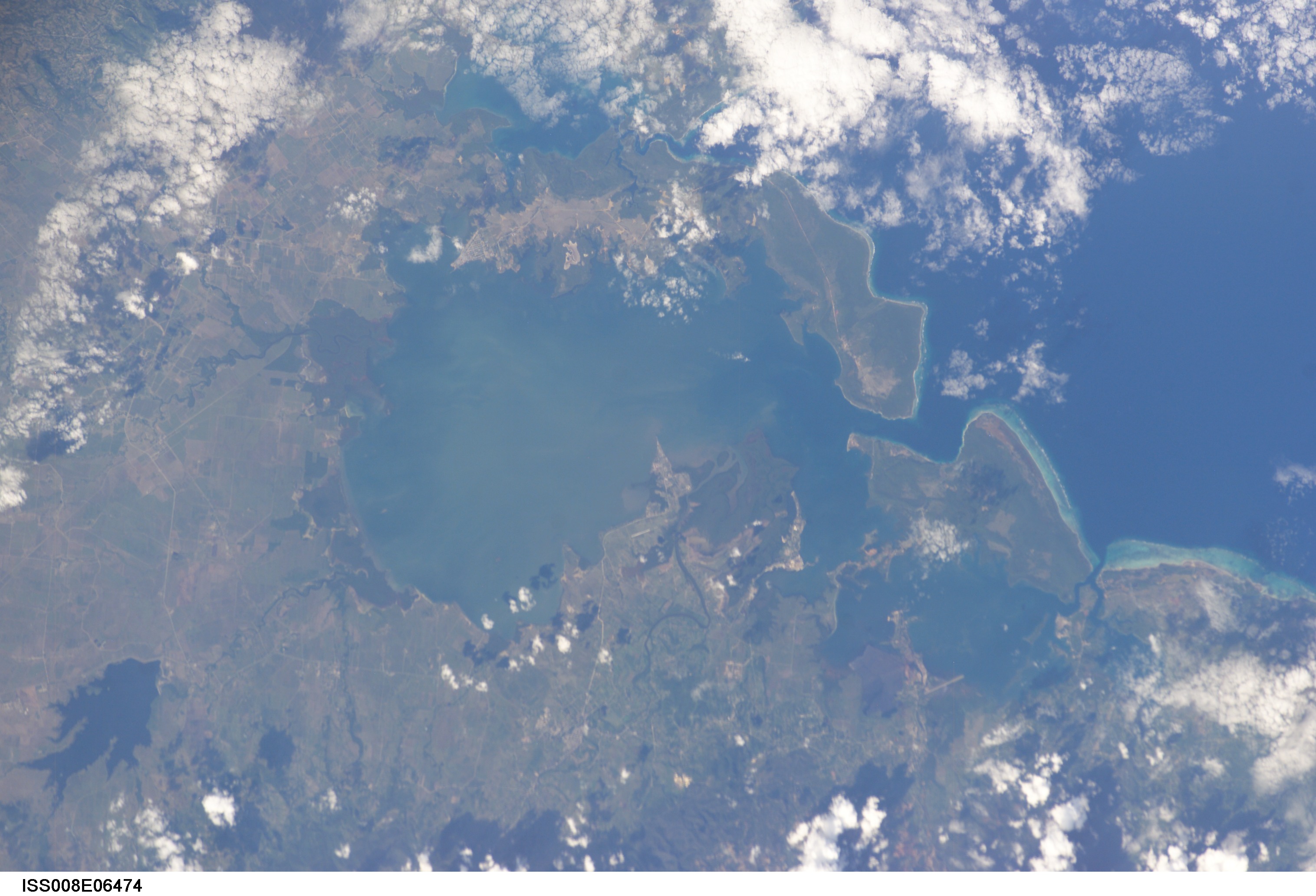
English: View of Cuba taken during ISS Expedition 8. Holguín Province, about 140 km from the East point of Cuba: Nipe bay (Spanish: Bahía de Nipe), municipalities of Mayarí (to the south) and Antilla (to the north). Also shows Cajimaya bay (east of Nipe bay) and Levisa bay (south-east of Cajimaya bay), with Cabonico bay on its east side (rather indistinct here). Cabonico bay uses the same outlet to the sea as Levisa bay an that outlet is very clear in this picture as a double-pronged fork. This shows the village of Guatemala (south side, with a point sticking out in the bay) just left (west) of the Mayarí river, and Felton on the right (east) of that river.
Mayarí is just south of Guatemala and Antilla in on the north shore. |
| Date | |
| Source | JSC Gateway to Astronaut Photography of Earth |
| Auteur | Earth Science and Remote Sensing Unit, centre spatial Lyndon B. Johnson |
| Mission | ISS008 |
| Roll | E |
| Frame | 6474 |
| Geographic area | Cuba |
| Features | BAY OF NIPE, ANTILLA, REEFS |
| Cloud percentage | 25% |
| Altitude | 202 nautical miles (374 km) |
| Look angle | 36 |
| Look direction | NE |
| Sun Azimuth | 222° |
| Sun Elevation | 36° |
| Camera | Kodak DCS760c Electronic Still Camera |
| Focal length | 200 mm |
| Lieu de la prise de vue | | Voir cet endroit et d’autres images sur : OpenStreetMap |
|---|
.jpg¶ms=019.400000_N_-077.300000_E_globe:Earth_type:camera__&language=fr)
| Position de l'objet | | Voir cet endroit et d’autres images sur : OpenStreetMap |
|---|
.jpg¶ms=021.000000_N_-075.500000_E_globe:Earth_class:object_type:object__&language=fr)
Cette image ou vidéo a été cataloguée par le Johnson Space Center de la National Aeronautics and Space Administration (NASA) des États-Unis sous Photo ID : ISS008-E-6474.Ce bandeau n’indique rien sur le statut de l’œuvre au regard du droit d'auteur. Un bandeau de droit d’auteur est requis. Voir Commons:À propos des licences pour plus d’informations. Autres langues :
|
Conditions d’utilisation
| Ce fichier provient de la NASA. Sauf exception, les documents créés par la NASA ne sont pas soumis à copyright. Pour plus d'informations, voir la politique de copyright de la NASA. | ||
 |
Attention :
|
Historique du fichier
Cliquer sur une date et heure pour voir le fichier tel qu'il était à ce moment-là.
| Date et heure | Vignette | Dimensions | Utilisateur | Commentaire | |
|---|---|---|---|---|---|
| actuel | 22 septembre 2022 à 08:07 | | 3 032 × 2 064 (887 kio) | AskeBot |
.jpg)