
Fichier:Kaliumchlorid-Feld in der Wüste Lop Nor.jpg

Fichier d’origine (1 174 × 1 821 pixels, taille du fichier : 1,22 Mio, type MIME : image/jpeg)
Ce fichier et sa description proviennent de Wikimedia Commons.
| Description |
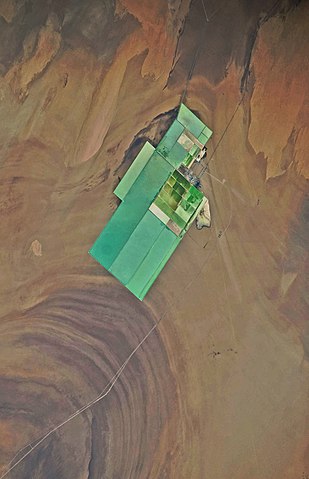
English: The world's largest potash fertilizer production base in the size 10 to 21 km is built in the former Lake Lop Nur, Xinjiang, China. The first phase of the project which has an annual capacity of 1.2 million tons was put into operation on Dec.18, 2008. The second phase with an annual capacity of 1.7 million tons has been launched 2009 and will be operational in 2014. The 3 million program will make Lop Nor the largest potash fertilizer production base in the world. The Project of Development and Utilization of Sylvite Resources in Lop Nur region employs the technique of producing potassium sulphate through magnesium sulfate subtype brine, which filled a technological gas of this kind and made China among the fewer countries that could produce potassium sulphate from brine directly taken from salt lake. The satellite picture is taken 2009-10-12. For more informatiom see here, here
and here.
Deutsch: Im Seebecken Lop Nor in Xinjiang, in China befindet sich dieses 2008 fertiggestellte 21 km lange und 10 km breite Kaliumchloridwerk, in dem Pottasche-Dünger hergestellt wird. Das Seebecken Lop Nor ist eine sedimentäre Salzlagerstätte von sylvinitischem Kalisalz für die Herstellung von Pottasche und enthält das größte Vorkommen von Sylvin in China. Es verfügt über 240 Millionen Tonnen Kaliumchlorid und hat insgesamt geschätzte Reserven von 500 Millionen Tonnen Kalisalz. Die bestätigten Vorkommen befinden sich in einem Gebiet, das sich 60,5 km von Nord nach Süd und 32,5 km von Ost nach West mit einer Gesamtfläche von 1.710 km² erstreckt. Die Erschließung eines Kaliumchlorid-Feldes durch die Lop Nur Sylvite Science and Technology Development Co. Ltd auf einer Fläche von 21,6km² und der Bau der Pilotanlage wurden bis 2003 fertiggestellt. Ein Kaliumchloridwerk konnte bereits in seiner Testphase rund 1.000 Tonnen hochwertigen Kaliumsulfats erzeugen. Bis Ende 2003 belief sich der Ausstoß auf 5.000 Tonnen Kaliumsulfat. Die Pilotanlage wurde bis Dezember 2008 nach Süden hin zur jährlichen Herstellung von 1,2 Millionen Tonnen Pottasche-Dünger vergrößert. Das Werk soll bis zum Jahr 2014 erneut erheblich erweitert werden, damit dann jährlich insgesamt 3 Millionen Tonnen Pottasche-Dünger hergestellt werden können. Seit 2006 gibt es einen Highway, der die Stadt Hami mit dem Werksgelände verbindet. Im Juni 2009 begann zusätzlich der Bau einer 360 Kilometer langen Eisenbahnstrecke von Hami zu diesem Werksgelände. Die Satellitenaufnahme wurde am 12. Oktober 2009 aufgenommen. |
|||||
| Date | ||||||
| Source |
Identification: NASA-Mission: ISS021 Roll: E Frame: 5961 Mission ID on the Film or image: ISS021. Country or Geographic Name: CHINA. Features: LOP NUR, SALT PONDS, DESERT. Center Point Latitude: 40.3 Center Point Longitude: 90.7 (Negative numbers indicate south for latitude and west for longitude). Camera: Camera Tilt: 36. Camera Focal Length: 200mm. Camera: N3. Film: 4256E : 4256 x 2832 pixel CMOS sensor, 36.0mm x 23.9mm, total pixels: 12.87 million, Nikon FX format. Nadir: Date: 20091012 (YYYYMMDD)GMT Time: 061853 (HHMMSS). Nadir Point Latitude: 40.1, Longitude: 88.5 (Negative numbers indicate south for latitude and west for longitude). Nadir to Photo Center Direction: East. Sun Azimuth: 189 (Clockwise angle in degrees from north to the sun measured at the nadir point). Spacecraft Altitude: 182 nautical miles (337 km). Sun Elevation Angle: 42 (Angle in degrees between the horizon and the sun, measured at the nadir point). Orbit Number: 2439.
|
|||||
| Auteur | NASA. | |||||
| Autorisation (Réutilisation de ce fichier) |
|
|||||
| Autres versions | File:Salt field in the Lop Nur Desert.jpg |

| Lieu de la prise de vue | | Voir cet endroit et d’autres images sur : OpenStreetMap |
|---|
Cette image ou vidéo a été cataloguée par l’un des centres de la National Aeronautics and Space Administration (NASA) des États-Unis sous Photo ID : ISS021-E-5961.Ce bandeau n’indique rien sur le statut de l’œuvre au regard du droit d'auteur. Un bandeau de droit d’auteur est requis. Voir Commons:À propos des licences pour plus d’informations. Autres langues :
|
Historique du fichier
Cliquer sur une date et heure pour voir le fichier tel qu'il était à ce moment-là.
| Date et heure | Vignette | Dimensions | Utilisateur | Commentaire | |
|---|---|---|---|---|---|
| actuel | 5 février 2010 à 18:39 | | 1 174 × 1 821 (1,22 Mio) | Michael Gäbler | Update |
| 1 février 2010 à 22:42 |  | 1 452 × 1 862 (1,49 Mio) | Michael Gäbler | Update | |
| 27 janvier 2010 à 23:14 |  | 1 496 × 1 827 (1,09 Mio) | Michael Gäbler | {{Information| |Description = {{en|China, Xinjiang, desert Lop Nur. Satellite picture of the Lop Desert with the Basin of the formerly sea Lop Nur. You see the Salt field by the Lop Nur Sylvite Science and Technology Development Co. Ltd.. For mor |
Utilisation du fichier
La page suivante utilise ce fichier :
Usage global du fichier
Les autres wikis suivants utilisent ce fichier :
- Utilisation sur de.wikipedia.org
- Utilisation sur ja.wikipedia.org
- Utilisation sur ko.wikipedia.org