
Fichier:Landsat7 dry valley lrg.jpg

Fichier d’origine (6 245 × 3 640 pixels, taille du fichier : 2,96 Mio, type MIME : image/jpeg)
Ce fichier et sa description proviennent de Wikimedia Commons.
Description
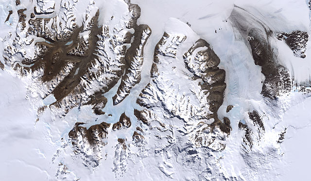
McMurdo Dry Valleys, Antarctica
From: http://visibleearth.nasa.gov/view_rec.php?id=2414
Credit: Image by Robert Simmon, based on data provided by the NASA GSFC Oceans and Ice Branch and the Landsat 7 Science Team
One of the few areas of Antarctica not covered by thousands of meters of ice, the McMurdo Dry Valleys stand out in this satellite image. For a few weeks each summer temperatures are warm enough to melt glacial ice, creating streams that feed freshwater lakes that lie at the bottom of the valleys. Beneath a cap of ice these lakes remains unfrozen year-round, supporting colonies of bacteria and phytoplankton. Over the past 14 years, however, summers have been colder than usual, and the lakes are becoming more and more frozen. If the trend continues, the biological communities they support may go into hibernation.
Most of Antarctica has cooled along with the Dry Valleys, in contrast to much of the rest of the Earth, which has warmed over the past 100 years. No one knows if the trend is related to global climate, or just a quirk in the weather.
This image was acquired by Landsat 7’s Enhanced Thematic Mapper plus (ETM+) instrument on December 18, 1999.
Conditions d’utilisation
| Ce fichier provient de la NASA. Sauf exception, les documents créés par la NASA ne sont pas soumis à copyright. Pour plus d'informations, voir la politique de copyright de la NASA. | ||
 |
Attention :
|
| Annotations | Cette image est annotée : Voir les annotations sur Wikimedia Commons |
Historique du fichier
Cliquer sur une date et heure pour voir le fichier tel qu'il était à ce moment-là.
| Date et heure | Vignette | Dimensions | Utilisateur | Commentaire | |
|---|---|---|---|---|---|
| actuel | 4 juillet 2007 à 22:45 | | 6 245 × 3 640 (2,96 Mio) | Xhienne | Losslessly removed progressive marker so that a thumbnail can be generated |
| 2 janvier 2006 à 02:51 |  | 6 245 × 3 640 (2,91 Mio) | Aude | McMurdo Dry Valleys, Antarctica ''From: [http://visibleearth.nasa.gov/view_rec.php?id=2414 http://visibleearth.nasa.gov/view_rec.php?id=2414] Credit: Image by Robert Simmon, based on data provided by the NASA GSFC Oceans and Ice Branch and the Landsat 7 |
Utilisation du fichier
La page suivante utilise ce fichier :
Usage global du fichier
Les autres wikis suivants utilisent ce fichier :
- Utilisation sur ar.wikipedia.org
- Utilisation sur az.wikipedia.org
- Utilisation sur ca.wikipedia.org
- Utilisation sur de.wikipedia.org
- Utilisation sur en.wikipedia.org
- Utilisation sur en.wikiversity.org
- Utilisation sur es.wikipedia.org
- Utilisation sur fa.wikipedia.org
- Utilisation sur fi.wikipedia.org
- Utilisation sur nl.wikipedia.org
- Utilisation sur nn.wikipedia.org
- Utilisation sur no.wikipedia.org
- Utilisation sur pl.wikipedia.org
- Utilisation sur pt.wikipedia.org
- Utilisation sur tr.wikipedia.org
- Utilisation sur uk.wikipedia.org