
Fichier:Level IV ecoregions, Eastern Cascades.png

Taille de cet aperçu : 215 × 597 pixels. Autres résolutions : 86 × 240 pixels | 604 × 1 678 pixels.
Fichier d’origine (604 × 1 678 pixels, taille du fichier : 748 kio, type MIME : image/png)
Ce fichier et sa description proviennent de Wikimedia Commons.
Description
| Description |
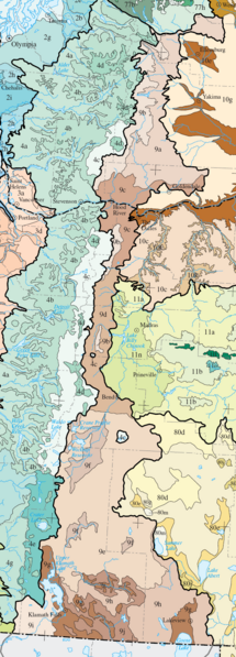
English: Level IV ecoregions in the Eastern Cascades Slopes and Foothills ecoregion, as defined by the EPA. This map is a draft and may now be slightly outdated. For more information about these ecoregions, see [1] |
| Source | Modified from US EPA map at [2] |
| Auteur | US Environmental Protection Agency |
| Autres versions |
 |
Conditions d’utilisation
Ce média est dans le domaine public des États-Unis d’Amérique car son auteur est l’administration américaine comme précisé dans le code fédéral au Titre 17, Chapitre 1, Section 105. Pour en savoir plus : droit d’auteur.
Attention : Ceci ne concerne que le travail du Gouvernement Fédéral et pas celui des États, ou d’une autre subdivision géographique ou politique du pays.
|
 | |
| Ce fichier a été identifié comme étant exempt de restrictions connues liées au droit d’auteur, y compris tous les droits connexes et voisins. | ||
Historique du fichier
Cliquer sur une date et heure pour voir le fichier tel qu'il était à ce moment-là.
| Date et heure | Vignette | Dimensions | Utilisateur | Commentaire | |
|---|---|---|---|---|---|
| actuel | 16 juin 2008 à 04:05 | 604 × 1 678 (748 kio) | Northwest-historian | {{Information |Description={{en|1= Level IV ecoregions in the Eastern Cascades Slopes and Foothills ecoregion, as defined by the EPA. This map is a draft and may now be slightly outdated. For more information about these ecoregions, see [http://www.epa.go |
Utilisation du fichier
La page suivante utilise ce fichier :
Usage global du fichier
Les autres wikis suivants utilisent ce fichier :
- Utilisation sur en.wikipedia.org
- Utilisation sur es.wikipedia.org
- Utilisation sur it.wikipedia.org