
Fichier:Liechtenstein administrative map-fr.svg

Taille de cet aperçu PNG pour ce fichier SVG : 459 × 599 pixels. Autres résolutions : 184 × 240 pixels | 368 × 480 pixels | 589 × 768 pixels | 785 × 1 024 pixels | 1 570 × 2 048 pixels | 1 301 × 1 697 pixels.
Fichier d’origine (Fichier SVG, nominalement de 1 301 × 1 697 pixels, taille : 505 kio)
Ce fichier et sa description proviennent de Wikimedia Commons.
Description
| Description |
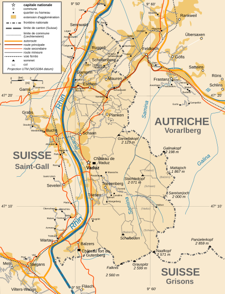
Français : Carte administrative en français du Liechtenstein Deutsch: Karte von Liechtenstein, französische Version English: Administrative map in French of Liechtenstein |
| Date | |
| Source |
Français : Création personnelle ; avec Inkscape ; projection UTM ; WGS84 datum ; Références utilisées pour les données complémentaires : * Rivières, villes, chemins de fers, routes : Demis add-on for World Wind (cf. l'e-mail d'approbation de Demis et le Demis forum) ; * Frontières et côtes : World data bank II + File:Liechtenstein-admin.png de user:Aotearoa English: Own work ; vectorized with Inkscape ; UTM projection ; WGS84 datum ; Reference used for the additional data : * Rivers, cities, railroads, routes : Demis add-on for World Wind (see the approval e-mail and the Demis forum) ; * Borders and coast : World data bank II + File:Liechtenstein-admin.png by user:Aotearoa Approximate geographic limits of the map (30" close) : * SW corner : 47°02'05"N – 9°40'00"E * SE corner : 47°02'05"N – 9°70'00"E * NE corner : 47°27'55"N – 9°70'00"E * NW corner : 47°27'55"N – 9°40'00"E |
| Auteur | Bourrichon - fr:Bourrichon |
| Autorisation (Réutilisation de ce fichier) |
GFDL / Attribution and Share-Alike required |
| Autres versions |
|


|
Ce fichier SVG contient du texte encapsulé pouvant facilement être traduit dans votre langue en utilisant n'importe quel éditeur de fichier SVG ou de texte, ou par l'outil de traduction de fichiers SVG. Pour plus d'informations, voir : A propos de la traduction des fichiers SVG. |
Conditions d’utilisation
Moi, en tant que détenteur des droits d’auteur sur cette œuvre, je la publie sous les licences suivantes :

|
Vous avez la permission de copier, distribuer et modifier ce document selon les termes de la GNU Free Documentation License version 1.2 ou toute version ultérieure publiée par la Free Software Foundation, sans sections inaltérables, sans texte de première page de couverture et sans texte de dernière page de couverture. Un exemplaire de la licence est inclus dans la section intitulée GNU Free Documentation License. |
This file is licensed under the Creative Commons Attribution-Share Alike Attribution-Share Alike 4.0 International, 3.0 Unported, 2.5 Generic, 2.0 Generic and 1.0 Generic license.
- Vous êtes libre :
- de partager – de copier, distribuer et transmettre cette œuvre
- d’adapter – de modifier cette œuvre
- Sous les conditions suivantes :
- paternité – Vous devez donner les informations appropriées concernant l'auteur, fournir un lien vers la licence et indiquer si des modifications ont été faites. Vous pouvez faire cela par tout moyen raisonnable, mais en aucune façon suggérant que l’auteur vous soutient ou approuve l’utilisation que vous en faites.
- partage à l’identique – Si vous modifiez, transformez, ou vous basez sur cette œuvre, vous devez distribuer votre contribution sous la même licence ou une licence compatible avec celle de l’original.
Vous pouvez choisir l’une de ces licences.
Historique du fichier
Cliquer sur une date et heure pour voir le fichier tel qu'il était à ce moment-là.
| Date et heure | Vignette | Dimensions | Utilisateur | Commentaire | |
|---|---|---|---|---|---|
| actuel | 15 janvier 2010 à 18:49 | | 1 301 × 1 697 (505 kio) | Bourrichon | corrections |
| 30 octobre 2009 à 22:22 |  | 1 301 × 1 697 (503 kio) | Koryakov Yuri | Reverted to version as of 18:42, 13 March 2009 | |
| 30 octobre 2009 à 22:21 |  | 1 301 × 1 697 (524 kio) | Koryakov Yuri | Added many villages | |
| 13 mars 2009 à 20:42 |  | 1 301 × 1 697 (503 kio) | Bourrichon | == Summary == {{Information |Description={{fr|Carte administrative en français du Liechtenstein}}{{de|Karte von Liechtenstein, französische Version}}{{en|Administrative map in French of [[:en:Liechtenstein|Lie |
Utilisation du fichier
Les 2 pages suivantes utilisent ce fichier :
Usage global du fichier
Les autres wikis suivants utilisent ce fichier :
- Utilisation sur de.wikipedia.org
- Utilisation sur en.wikipedia.org
- Utilisation sur rm.wikipedia.org
- Utilisation sur ru.wikipedia.org