Fichier:Map of the Gulf, Colorado and Santa Fe 'Texas Midland Route' 1880 UTA.jpg

Le contenu de la page n’est pas pris en charge dans d’autres langues.
Une page de Wikipédia, l'encyclopédie libre.

Fichier d’origine(9 230 × 8 592 pixels, taille du fichier : 13,64 Mio, type MIME : image/jpeg)

Ce fichier et sa description proviennent de Wikimedia Commons.

Description

Avertissement Certains navigateurs peuvent avoir des difficultés à afficher cette image à sa résolution complète : elle possède un nombre de pixels singulièrement élevé et peut ne pas se charger correctement ou faire planter votre navigateur.
Titre
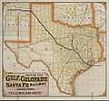
English: Gulf, Colorado and Santa Fe Railway and Connections. The "Texas Midland Route".
Description
English: This promotional map of Texas, Indian Territory, and parts of surrounding states is quite unusual in its almost fluorescent coloration. The text on the back of the map advertises "300 miles of track" and "better and surer connections" with trains of the International and Great Northern Railroad. Since the G.C. & S.F. wanted to promote this relationship, the map shows those lines thicker, although not as thick as the G.C.& S.F. itself. Not surprisingly, the thinner lines are reserved for the main competitor railroad: the Houston & Texas Central.
Date vers 1880
date QS:P,+1880-00-00T00:00:00Z/9,P1480,Q5727902
Source UTA Libraries Cartographic Connections: carte / texte
Créé par
Woodward, Tiernan & Hale et al.
Attribution de l’acquisition
English: The University of Texas at Arlington Libraries Special Collections
 Données géotemporelles
Lieu Texas
Géoréférencement Géoréférencer la carte dans Wikimaps Warper Si c'est inapproprié, définissez warp_status = skip pour masquer.
 Données bibliographiques
Lieu de publication Galveston
Éditeur de publication
Gulf, Colorado and Santa Fe Railway
Imprimé par
Woodward, Tiernan & Hale, Saint-Louis
 Données d'archives
institution QS:P195,Q1230739
Dimensions hauteur : 47 cm ; largeur : 51,5 cm
dimensions QS:P2048,47U174728
dimensions QS:P2049,51.5U174728
Technique / matériaux cerograph en couleurs
chromolithographie
medium QS:P186,Q1121337


Conditions d’utilisation

Public domain
Cette œuvre a été publiée avant le 1er janvier 1929. Son auteur n'étant pas connu, cette œuvre est anonyme. Elle est donc dans le domaine public aux États-Unis, ainsi que dans les pays où la durée du droit d'auteur pour les œuvres anonymes est inférieure à 95 ans après la date de première publication.

Légendes

Ajoutez en une ligne la description de ce que représente ce fichier

Éléments décrits dans ce fichier

dépeint

0,025 seconde

image/jpeg

Historique du fichier

Cliquer sur une date et heure pour voir le fichier tel qu'il était à ce moment-là.

Date et heureVignetteDimensionsUtilisateurCommentaire
actuel6 avril 2022 à 20:15Vignette pour la version du 6 avril 2022 à 20:159 230 × 8 592 (13,64 Mio)Michael Barera== {{int:filedesc}} == {{Map |title = {{en|'''''Gulf, Colorado and Santa Fe Railway and Connections. The "Texas Midland Route".'''''}} |description = {{en|This promotional map of Texas, Indian Territory, and parts of surrounding states is quite unusual in its almost fluorescent coloration. The text on the back of the map advertises "300 miles of track" and "better and surer connections" with trains of the International and Great Northern Railroad. Since the G.C. & S.F. wan...

La page suivante utilise ce fichier :

Usage global du fichier

Les autres wikis suivants utilisent ce fichier :

Métadonnées