
Fichier:Map of the offshore wind power farms in the German Bight.png

Fichier d’origine (4 342 × 3 483 pixels, taille du fichier : 2,6 Mio, type MIME : image/png)
Ce fichier et sa description proviennent de Wikimedia Commons.
Description
| Description |
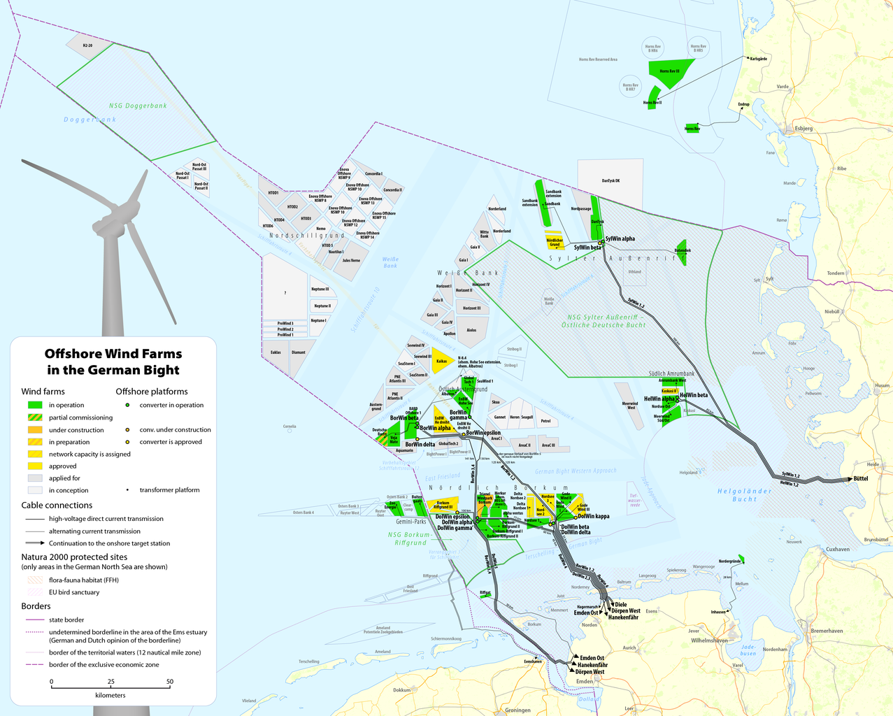
Deutsch: Karte der Offshore-Windkraftanlagen in der Deutschen Bucht sowie deren Kabelanbindungen
English: Map of offshore wind farms and connecting power cables in the German Bight |
|||
| Date | see file history | |||
| Source |
Travail personnel, using data and information from these web sites: |
|||
| Auteur | Maximilian Dörrbecker (Chumwa) | |||
| Autorisation (Réutilisation de ce fichier) |
Ce fichier est disponible selon les termes de la licence Creative Commons Attribution – Partage dans les Mêmes Conditions 2.0 Générique
Sie dürfen das Bild zu den folgenden Bedingungen nutzen:
|
|||
| Autres versions |
|


Historique du fichier
Cliquer sur une date et heure pour voir le fichier tel qu'il était à ce moment-là.
| Date et heure | Vignette | Dimensions | Utilisateur | Commentaire | |
|---|---|---|---|---|---|
| actuel | 13 juin 2020 à 10:14 | | 4 342 × 3 483 (2,6 Mio) | Chumwa | update |
| 21 janvier 2020 à 22:25 |  | 4 342 × 3 483 (2,61 Mio) | Chumwa | update | |
| 4 septembre 2018 à 23:41 |  | 4 342 × 3 483 (2,6 Mio) | Chumwa | update | |
| 23 juin 2018 à 17:13 |  | 4 342 × 3 483 (2,61 Mio) | Chumwa | corr | |
| 22 juin 2018 à 16:47 |  | 4 342 × 3 483 (2,6 Mio) | Chumwa | update | |
| 6 janvier 2018 à 12:32 |  | 4 342 × 3 483 (2,53 Mio) | Chumwa | update | |
| 21 juin 2017 à 22:12 |  | 4 342 × 3 483 (2,53 Mio) | Chumwa | update | |
| 7 mai 2017 à 09:19 |  | 4 342 × 3 483 (2,53 Mio) | Chumwa | ||
| 28 avril 2017 à 23:59 |  | 4 342 × 3 483 (2,53 Mio) | Chumwa | update | |
| 15 avril 2017 à 09:43 |  | 4 342 × 3 483 (2,51 Mio) | Chumwa | {{Information |Description= |Source={{own}} |Date= |Author= Chumwa |Permission= |other_versions= }} == {{int:filedesc}} == {{Information |Description = {{de|1=Karte der Offshore-Windkraftanlagen in der Deutschen Bucht sowie deren Kab... |
Utilisation du fichier
La page suivante utilise ce fichier :
Usage global du fichier
Les autres wikis suivants utilisent ce fichier :
- Utilisation sur de.wikipedia.org
- Utilisation sur en.wikipedia.org
- Utilisation sur nl.wikipedia.org
- Utilisation sur ru.wikipedia.org
- Utilisation sur uz.wikipedia.org
- Utilisation sur www.wikidata.org