
Fichier:Mapa de Amenaza Sísmica de Colombia.png
Taille de cet aperçu : 524 × 600 pixels. Autres résolutions : 210 × 240 pixels | 419 × 480 pixels | 671 × 768 pixels | 894 × 1 024 pixels | 2 000 × 2 290 pixels.
Fichier d’origine (2 000 × 2 290 pixels, taille du fichier : 4,7 Mio, type MIME : image/png)
Ce fichier et sa description proviennent de Wikimedia Commons.
Description
| Description |
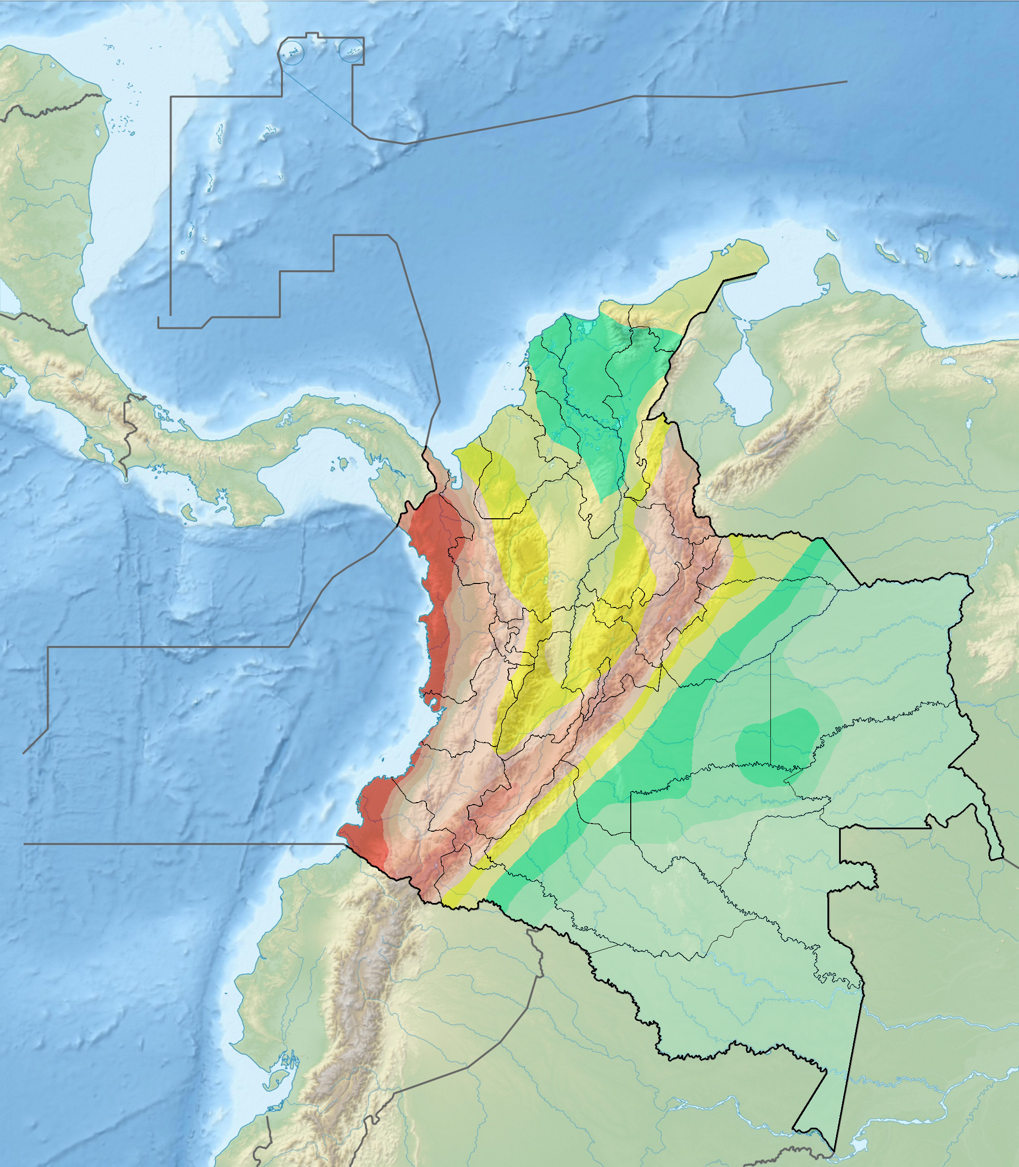
Français : Carte du risque sismique en Colombie |
| Date | |
| Source |
background : File:Colombia relief location map.jpg data : INGEOMINAS |
| Auteur | Grundkarte Milenioscuro, Relief Alexrk2 |
Conditions d’utilisation
Ce fichier est disponible selon les termes de la licence Creative Commons Attribution – Partage dans les Mêmes Conditions 3.0 (non transposée).
- Vous êtes libre :
- de partager – de copier, distribuer et transmettre cette œuvre
- d’adapter – de modifier cette œuvre
- Sous les conditions suivantes :
- paternité – Vous devez donner les informations appropriées concernant l'auteur, fournir un lien vers la licence et indiquer si des modifications ont été faites. Vous pouvez faire cela par tout moyen raisonnable, mais en aucune façon suggérant que l’auteur vous soutient ou approuve l’utilisation que vous en faites.
- partage à l’identique – Si vous modifiez, transformez, ou vous basez sur cette œuvre, vous devez distribuer votre contribution sous la même licence ou une licence compatible avec celle de l’original.
Historique du fichier
Cliquer sur une date et heure pour voir le fichier tel qu'il était à ce moment-là.
| Date et heure | Vignette | Dimensions | Utilisateur | Commentaire | |
|---|---|---|---|---|---|
| actuel | 30 décembre 2011 à 16:01 | | 2 000 × 2 290 (4,7 Mio) | Dr Brains |
Utilisation du fichier
La page suivante utilise ce fichier :
Usage global du fichier
Les autres wikis suivants utilisent ce fichier :
- Utilisation sur ast.wikipedia.org
- Utilisation sur en.wikipedia.org
- South American Plate
- Caribbean Plate
- 1994 Páez River earthquake
- 1875 Cúcuta earthquake
- 1999 Colombia earthquake
- Geology of Colombia
- 2008 El Calvario earthquake
- North Andes Plate
- Panama Plate
- 1906 Ecuador–Colombia earthquake
- 1868 Ecuador earthquakes
- List of earthquakes in Colombia
- 1958 Ecuador–Colombia earthquake
- 1979 Tumaco earthquake
- 1970 Colombia earthquake
- 1983 Popayán earthquake
- Oca-Ancón Fault System
- Boconó Fault
- 2016 Ecuador earthquake
- User:Tisquesusa/sandbox8
- Template:Tectonism in Colombia
- Bucaramanga-Santa Marta Fault
- Malpelo Plate
- 1992 Murindó earthquake
- 1967 Neiva earthquake
- Eastern Frontal Fault System
- Romeral Fault System
- Montenegro Fault
- Armenia Fault
- Córdoba-Navarco Fault
- Paraíso Fault
- Piendamó Fault
- Rosas-Julumito Fault
- Buesaco-Aranda Fault
- Abriaquí Fault
- Argelia Fault
- Bagre Norte Fault
- Bahía Solano Fault
- Cañasgordas Fault
- Caño Tomás Fault
- Cimitarra Fault
- Cucuana Fault
- El Tambor Fault
- Espiritú Santo Fault System
- Garrapatas Fault Zone
- Guáitara Fault
- Honda Fault
- Ibagué Fault
- Irlanda Fault
Voir davantage sur l’utilisation globale de ce fichier.