
Fichier:NASA Manhattan.jpg

Taille de cet aperçu : 253 × 599 pixels. Autres résolutions : 101 × 240 pixels | 604 × 1 431 pixels.
Fichier d’origine (604 × 1 431 pixels, taille du fichier : 599 kio, type MIME : image/jpeg)
Ce fichier et sa description proviennent de Wikimedia Commons.
Description
| Description |
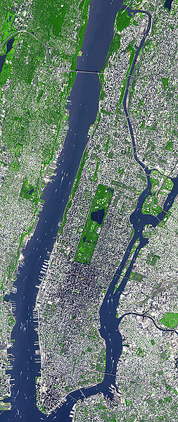
English: This false-color satellite image shows Manhattan, with Queens and Brookyn to the south east and New Jersey to the west. Central Park is visible in the center. This false-color image was acquired on Sept. 8, 2002, by the Advanced Spaceborne Thermal Emission and Reflection Radiometer (ASTER) aboard NASA's Terra satellite. Vegetated land surface is green, paved urban areas are a whitish blue, and water is dark blue. Image cropped by the uploader on 5 August 2006. |
| Date | |
| Source | http://earthobservatory.nasa.gov/Newsroom/NewImages/images.php3?img_id=15368 |
| Auteur | Image courtesy NASA/GSFC/MITI/ERSDAC/JAROS, and U.S./Japan ASTER Science Team |
| Autres versions | Œuvres dérivées de ce fichier : Manhattanhenge map.svg |
Conditions d’utilisation
| Ce fichier provient de la NASA. Sauf exception, les documents créés par la NASA ne sont pas soumis à copyright. Pour plus d'informations, voir la politique de copyright de la NASA. | ||
 |
Attention :
|
Journal des téléversements d’origine
La page de description originale était ici. Tous les noms d'utilisateur qui suivent se rapportent à en.wikipedia.
- 2006-08-05 18:48 Wv235 604×1431×8 (613881 bytes) This false-color satellite image shows Manhattan, with Queens and Brookyn to the south east and New Jersey to the west. Central Park is visible in the center. This false-color image was acquired on Sept. 8, 2002, by the Advanced Spaceborne Thermal Emissi
Historique du fichier
Cliquer sur une date et heure pour voir le fichier tel qu'il était à ce moment-là.
| Date et heure | Vignette | Dimensions | Utilisateur | Commentaire | |
|---|---|---|---|---|---|
| actuel | 24 juin 2007 à 15:49 | | 604 × 1 431 (599 kio) | Ulfer | {{Information |Description=This false-color satellite image shows Manhattan, with Queens and Brookyn to the south east and New Jersey to the west. Central Park is visible in the center. This false-color image was acquired on Sept. 8, 2002, by the Advance |
Utilisation du fichier
La page suivante utilise ce fichier :
Usage global du fichier
Les autres wikis suivants utilisent ce fichier :
- Utilisation sur af.wikipedia.org
- Utilisation sur cs.wikipedia.org
- Utilisation sur cy.wikipedia.org
- Utilisation sur de.wikipedia.org
- Utilisation sur en.wikipedia.org
- Utilisation sur en.wiktionary.org
- Utilisation sur et.wikipedia.org
- Utilisation sur fa.wikipedia.org
- Utilisation sur fo.wikipedia.org
- Utilisation sur gu.wikipedia.org
- Utilisation sur he.wikipedia.org
- Utilisation sur hi.wikipedia.org
- Utilisation sur it.wikipedia.org
- Utilisation sur kn.wikipedia.org
- Utilisation sur ko.wikipedia.org
- Utilisation sur mai.wikipedia.org
- Utilisation sur ml.wikipedia.org
- Utilisation sur no.wikipedia.org
- Utilisation sur pt.wikipedia.org
- Utilisation sur ru.wikipedia.org
- Utilisation sur scn.wikipedia.org
- Utilisation sur simple.wikipedia.org
- Utilisation sur ta.wikipedia.org
- Utilisation sur uk.wikipedia.org
- Utilisation sur yi.wikipedia.org
- Utilisation sur zh.wikipedia.org