
Fichier:Persian invasion.png
Taille de cet aperçu : 430 × 599 pixels. Autres résolutions : 172 × 240 pixels | 538 × 750 pixels.
Fichier d’origine (538 × 750 pixels, taille du fichier : 41 kio, type MIME : image/png)
Ce fichier et sa description proviennent de Wikimedia Commons.
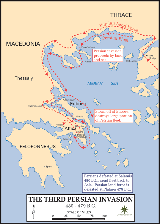
English: Map of the Persian invasion of Greece (480 BC-479 BC). Taken from
Català: Mapa de la invasió pèrsica de Grècia (480 aC - 479 aC). Obtingut de:
http://www.dean.usma.edu/history/atlases/ancient_warfare/persian_invasion_3.html

|
Vous avez la permission de copier, distribuer et modifier ce document selon les termes de la GNU Free Documentation License version 1.2 ou toute version ultérieure publiée par la Free Software Foundation, sans sections inaltérables, sans texte de première page de couverture et sans texte de dernière page de couverture. Un exemplaire de la licence est inclus dans la section intitulée GNU Free Documentation License. |
This is the first of two images, the second being Image:Battle thermopylae.png.
Historique du fichier
Cliquer sur une date et heure pour voir le fichier tel qu'il était à ce moment-là.
| Date et heure | Vignette | Dimensions | Utilisateur | Commentaire | |
|---|---|---|---|---|---|
| actuel | 9 décembre 2007 à 07:16 | | 538 × 750 (41 kio) | AnonMoos | Reverted to version as of 16:13, 24 February 2006 - rv overwriting of completely different image |
| 9 décembre 2007 à 04:25 |  | 653 × 520 (369 kio) | Megistias | == Summary == {{Information |Description=Map of "Map of the Persian invasion of Greece (480 BC-479 BC)" |Source=Own work.Data from dtv-Atlas Weltgeschichte. Von den Anfängen bis zur Gegenwart, p. 56. & from previous map whose link seems to be dead. |Date | |
| 24 février 2006 à 18:13 |  | 538 × 750 (41 kio) | Brian Boru | Map of the Persian invasion of Greece (480 BC-479 BC). Taken from http://www.dean.usma.edu/history/atlases/ancient_warfare/persian_invasion_3.html {{CopyrightedFreeUseProvidedThat|the source is quoted: «''Maps Courtesy of the Department of History, Unit |
Utilisation du fichier
La page suivante utilise ce fichier :
Usage global du fichier
Les autres wikis suivants utilisent ce fichier :
- Utilisation sur be.wikipedia.org
- Utilisation sur bg.wikipedia.org
- Utilisation sur ca.wikipedia.org
- Utilisation sur cy.wikipedia.org
- Utilisation sur en.wikipedia.org
- Utilisation sur es.wikipedia.org
- Utilisation sur fi.wikipedia.org
- Utilisation sur gl.wikipedia.org
- Utilisation sur it.wikipedia.org
- Utilisation sur ja.wikipedia.org
- Utilisation sur no.wikipedia.org
- Utilisation sur pl.wikibooks.org
- Utilisation sur pt.wikipedia.org
- Utilisation sur ro.wikipedia.org
- Utilisation sur sh.wikipedia.org
- Utilisation sur simple.wikipedia.org
- Utilisation sur sv.wikipedia.org
- Utilisation sur zh.wikipedia.org