Fichier:Port Arthur Aerial photo of restoration projects.jpg

Le contenu de la page n’est pas pris en charge dans d’autres langues.
Une page de Wikipédia, l'encyclopédie libre.

Fichier d’origine(602 × 640 pixels, taille du fichier : 112 kio, type MIME : image/jpeg)

Ce fichier et sa description proviennent de Wikimedia Commons.

Description

Description
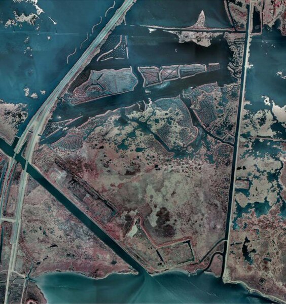
English: Case: Chevron/Former Gulf Oil Refinery waste site between Port Arthur and Bridge City, Texas, east of the Rainbow Bridge

Status:

Restoration construction is complete
Monitoring to ensure success criteria achieved and identifying the need for corrective actions
Selected restoration alternatives are creation of 83 acres of tidal wetland, 30 acres of coastal wet prairie, and placement of water control structures to improve 1,332 acres of coastal wetlands in the Sabine/Neches River basin

Restoration for Benthic and Wildlife Resources:

Marsh construction and enhancement in the Former River South Unit of the Lower Neches Wildlife Management Area (WMA), adjacent to Sabine Lake near Port Arthur, Jefferson County, Texas. Construction of estuarine marsh consisting of a minimum of 60-70% vegetation and 30-40% open water (the Marsh Complex) via the beneficial use of dredge material. The original material from the construction of the Gulf States Utility canal presently stored in a dredge material management area adjacent the WMA will be used to create a field of pimple mounds and terraces. Construction of a low water plug in the lower end of the Ferry Road Canal and addition of eight culverts under Ferry Road will ensure adequate surface water circulation and exchange. The Marsh Complex will be built via reuse of dredged material from a borrow area and terracing of existing sediments in existing open water areas.
Construction of coastal wet prairie (the Coastal Wet Prairie). After removal of the soil to be used for creation of the marsh complex is removed, the Dredge Material Management Area will be graded into a landscape of swales, mounds and ponds and planted with wet prairie plants native to southeastern Texas.
Construction of Water Control Structures and levees necessary to restore and enhance the soil moisture in impoundments for enhanced wildlife management of the J.D. Murphree WMA located near the City of Port Arthur, Jefferson County, Texas. The water levels within these wetlands are managed by the TPWD. The project consists of constructing a water control structure and a low terrace with an adjacent ditch and plugging an existing ditch in the project area. This project resulted in additional improvement of over 600 acres of emergent and high marsh habitat.
Date Date inconnue
Unknown date
Source http://www.darrp.noaa.gov/southeast/chevron_port_arthur/images/overhead_view.jpg
Auteur Chevron

]]

Conditions d’utilisation

Public domain
Ce média est dans le domaine public des États-Unis d’Amérique car son auteur est l’administration américaine comme précisé dans le code fédéral au Titre 17, Chapitre 1, Section 105. Pour en savoir plus : droit d’auteur. Attention : Ceci ne concerne que le travail du Gouvernement Fédéral et pas celui des États, ou d’une autre subdivision géographique ou politique du pays.

Historique du fichier

Cliquer sur une date et heure pour voir le fichier tel qu'il était à ce moment-là.

Date et heureVignetteDimensionsUtilisateurCommentaire
actuel24 avril 2011 à 18:19Vignette pour la version du 24 avril 2011 à 18:19602 × 640 (112 kio)Gary Dee{{Information |Description ={{en|1=Case: Chevron/Former Gulf Oil Refinery Port Arthur waste site Status: Restoration construction is complete Monitoring to ensure success criteria achieved and identifying the need for corrective actions

Les 2 pages suivantes utilisent ce fichier :

Métadonnées