
Fichier:Remembrance for the Drowned - geograph.org.uk - 679587.jpg
Pas de plus haute résolution disponible.
Remembrance_for_the_Drowned_-_geograph.org.uk_-_679587.jpg (640 × 427 pixels, taille du fichier : 105 kio, type MIME : image/jpeg)
Ce fichier et sa description proviennent de Wikimedia Commons.
Description
| Description |
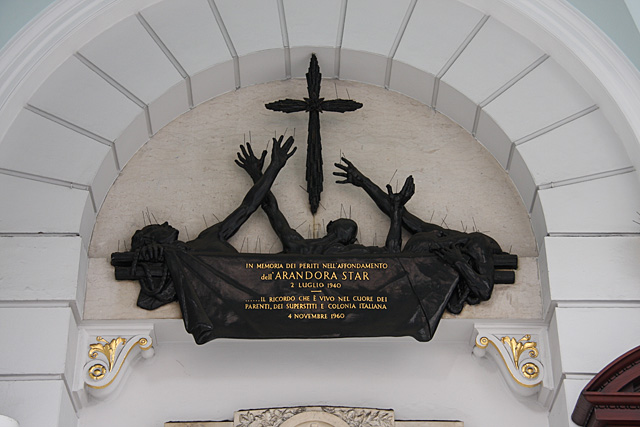
English: Remembrance for the Drowned This memorial, at the entrance to the Chiesa Italiana di San Pietro, Holborn, London, recalls the sinking of Blue Star Lines Arandora Star by U-47 on 7th July 1940, under the command of Gunther Prien - a highly rated captain of the German U-Boat corps who had successfully entered Scapa Flow and sunk the British Cruiser Royal Oak in 1939. The Arandora Star was carrying civilian German and Italian internees from Liverpool to Canada. Over 800 lives were lost. Subsequently, the British government altered its policy towards internees and held them within the British Isles. There is currently a campaign seeking an apology from the British government for the policy decisions that led to these deaths. For fuller info please see the Blue Star Lines website at http://www.bluestarline.org/index.html and the campaign website at http://www.arandorastarcampaign.com/ |
| Date | |
| Source | From geograph.org.uk |
| Auteur | Martin Addison |
| Attribution (imposé par la licence) | Martin Addison / Remembrance for the Drowned / |
| Lieu de la prise de vue | | Voir cet endroit et d’autres images sur : OpenStreetMap |
|---|
_heading:0.00&language=fr)
| Position de l'objet | | Voir cet endroit et d’autres images sur : OpenStreetMap |
|---|
_heading:0.00&language=fr)
Conditions d’utilisation

|
Cette image provient de la collection du projet Geograph British Isles. Pour obtenir les coordonnées du photographe, veuillez consulter cette page de description de l'image sur le site du projet. Les droits d'auteurs sur cette image sont détenus par Martin Addison ; l'image est placée sous une licence Creative Commons avec mention de paternité et partage à l'identique (CC-By-SA) en version 2.0.
|
Ce fichier est disponible selon les termes de la licence Creative Commons Attribution – Partage dans les Mêmes Conditions 2.0 Générique
Attribution: Martin Addison
- Vous êtes libre :
- de partager – de copier, distribuer et transmettre cette œuvre
- d’adapter – de modifier cette œuvre
- Sous les conditions suivantes :
- paternité – Vous devez donner les informations appropriées concernant l'auteur, fournir un lien vers la licence et indiquer si des modifications ont été faites. Vous pouvez faire cela par tout moyen raisonnable, mais en aucune façon suggérant que l’auteur vous soutient ou approuve l’utilisation que vous en faites.
- partage à l’identique – Si vous modifiez, transformez, ou vous basez sur cette œuvre, vous devez distribuer votre contribution sous la même licence ou une licence compatible avec celle de l’original.
Historique du fichier
Cliquer sur une date et heure pour voir le fichier tel qu'il était à ce moment-là.
| Date et heure | Vignette | Dimensions | Utilisateur | Commentaire | |
|---|---|---|---|---|---|
| actuel | 8 février 2011 à 01:03 | | 640 × 427 (105 kio) | GeographBot | == {{int:filedesc}} == {{Information |description={{en|1=Remembrance for the Drowned This memorial, at the entrance to the Chiesa Italiana di San Pietro, recalls the sinking of Blue Star Lines Arandora Star by U-47 on 7th July 1940, under the command of G |
Utilisation du fichier
La page suivante utilise ce fichier :
Usage global du fichier
Les autres wikis suivants utilisent ce fichier :
- Utilisation sur de.wikipedia.org
- Utilisation sur en.wikipedia.org
- Utilisation sur id.wikipedia.org
- Utilisation sur ja.wikipedia.org