
Fichier:Robert-Island-location-map.png
Taille de cet aperçu : 800 × 548 pixels. Autres résolutions : 320 × 219 pixels | 640 × 439 pixels | 1 024 × 702 pixels | 1 280 × 877 pixels | 1 669 × 1 144 pixels.
Fichier d’origine (1 669 × 1 144 pixels, taille du fichier : 150 kio, type MIME : image/png)
Ce fichier et sa description proviennent de Wikimedia Commons.
Description
| Description |
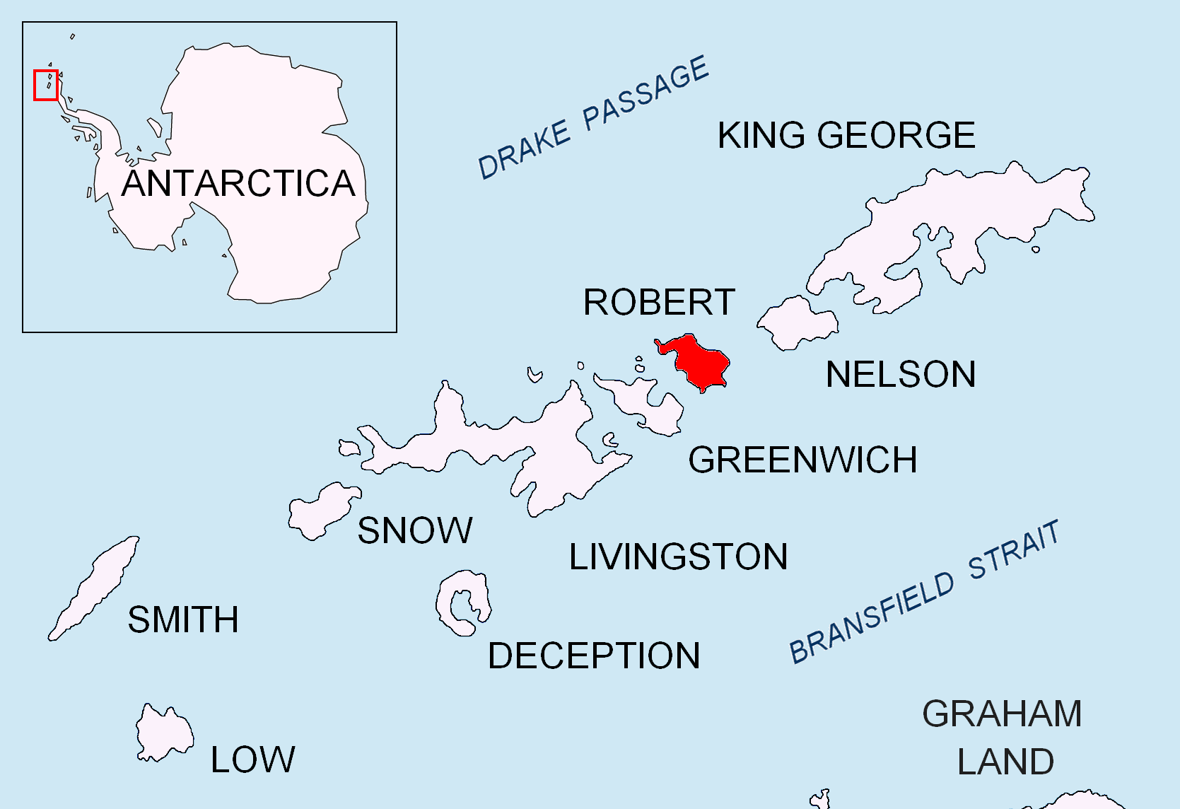
English: Location map of Robert Island in the South Shetland Islands. |
| Date | |
| Source | Travail personnel |
| Auteur | Apcbg |
Conditions d’utilisation
Moi, en tant que détenteur des droits d’auteur sur cette œuvre, je la publie sous les licences suivantes :
Ce fichier est disponible selon les termes de la licence Creative Commons Attribution – Partage dans les Mêmes Conditions 3.0 (non transposée).
- Vous êtes libre :
- de partager – de copier, distribuer et transmettre cette œuvre
- d’adapter – de modifier cette œuvre
- Sous les conditions suivantes :
- paternité – Vous devez donner les informations appropriées concernant l'auteur, fournir un lien vers la licence et indiquer si des modifications ont été faites. Vous pouvez faire cela par tout moyen raisonnable, mais en aucune façon suggérant que l’auteur vous soutient ou approuve l’utilisation que vous en faites.
- partage à l’identique – Si vous modifiez, transformez, ou vous basez sur cette œuvre, vous devez distribuer votre contribution sous la même licence ou une licence compatible avec celle de l’original.

|
Vous avez la permission de copier, distribuer et modifier ce document selon les termes de la GNU Free Documentation License version 1.2 ou toute version ultérieure publiée par la Free Software Foundation, sans sections inaltérables, sans texte de première page de couverture et sans texte de dernière page de couverture. Un exemplaire de la licence est inclus dans la section intitulée GNU Free Documentation License. |
Vous pouvez choisir l’une de ces licences.
Historique du fichier
Cliquer sur une date et heure pour voir le fichier tel qu'il était à ce moment-là.
| Date et heure | Vignette | Dimensions | Utilisateur | Commentaire | |
|---|---|---|---|---|---|
| actuel | 25 août 2010 à 13:30 | | 1 669 × 1 144 (150 kio) | Apcbg | + location in Antarctica |
| 27 avril 2010 à 20:37 |  | 1 669 × 1 144 (5,47 Mio) | Apcbg | {{Information |Description={{en|1=Location map of Robert Island in the South Shetland Islands.}} |Source={{own}} |Author=Apcbg |Date=2010-04-27 |Permission= |other_versions= }} Category:Maps of Antarctica |
Utilisation du fichier
Les 2 pages suivantes utilisent ce fichier :
Usage global du fichier
Les autres wikis suivants utilisent ce fichier :
- Utilisation sur az.wikipedia.org
- Mikalvi buxtası
- Kruni buxtası
- Zahari burnu
- Neqra burnu
- Edvards burnu
- Robert burnu
- Tsepina buxtası
- Somovit burnu
- Batuliya burnu
- Sadala burnu
- Kitçen burnu
- Smirnenski burnu
- Qarinya buxtası
- Divotino burnu
- Svetulka adası
- Osenovlaq adası
- Oeskus adası
- Redina adası
- Kovaç adası
- Qrod adası
- Çuriçeni adası
- Vilare adası
- Leeve adası
- Onoqur adaları
- Misnomer burnu
- Debelyanov burnu
- Hammer burnu
- Nevestino buxtası
- Katarina burnu
- Kozloduy buxtası
- Perelik burnu
- Vrabça buxtası
- Yundola buxtası
- Lavrenov burnu
- Uqarçi burnu
- Utilisation sur bg.wikipedia.org
Voir davantage sur l’utilisation globale de ce fichier.