
Fichier:Sediment plume at sea detail roma 3 days after rain.jpg

Fichier d’origine (4 500 × 3 180 pixels, taille du fichier : 6,5 Mio, type MIME : image/jpeg)
Ce fichier et sa description proviennent de Wikimedia Commons.
Description
| Description |
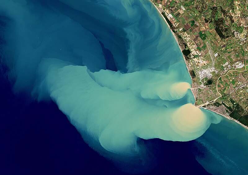
Français : Le satellite Copernicus Sentinel-2B a capturé cette image en couleurs vraies le 5 février 2019 : effluents du Tibre 3 jours après de fortes pluies à Rome et dans les environs du Latium, en Italie. Elle montre un panache de sédiments se répandant dans la mer Tyrrhénienne, une partie de la mer Méditerranée. Les averses du 2 février ont entraîné l'inondation des rues et la fermeture des berges du Tibre et de plusieurs routes.
Le fleuve Tibre peut être vu à droite ; 3ème plus long fleuve d'Italie, il prend sa source dans les Apennins et coule sur environ 400 km avant de traverser la ville de Rome et de se jeter dans la mer ici près de la ville d'Ostie. Le Tibre joue un rôle important dans le transport des sédiments, c'est pourquoi les eaux côtières y sont souvent turbides ; ici, les récentes pluies ont entraîné le déversement d’une grande quantité de sédiments dans la mer Tyrrhénienne, comme le montre cette image. Le panache de sédiments s'étend sur 28 km de la côte, emporté vers le nord-ouest par les courants. Copernicus Sentinel-2 est une mission composée de 2 satellites, dotés chacun d'un imageur multispectral haute résolution pour surveiller les changements de végétation. Il renseigne aussi sur la pollution des lacs et des eaux côtières.English: The Copernicus Sentinel-2B satellite captured this true-colour image on 5 February 2019, just three days after heavy rainfall in Rome and the surrounding area of Lazio, Italy. It shows sediment gushing into the Tyrrhenian Sea, part of the Mediterranean Sea. The downpour on 2 February led to flooded streets, the closing of the banks of the Tiber River and several roads.
The Tiber River can be seen snaking its way southwards in the image. The third longest river in Italy, it rises in the Apennine Mountains and flows around 400 km before flowing through the city of Rome and draining into the sea near the town of Ostia. The Tiber River plays an important role in sediment transport, so coastal waters here are often discoloured. However, the recent rains resulted in a large amount of sediment pouring into the Tyrrhenian Sea, as this image shows. The sediment plume can be seen stretching 28 km from the coast, carried northwest by currents. Copernicus Sentinel-2 is a two-satellite mission. Each satellite carries a high-resolution multispectral imager to monitor changes in vegetation. It also provides information on pollution in lakes and coastal waters. |
|||
| Date | ||||
| Source |
File:Sediment_plume_at_sea.jpg from : http://www.esa.int/spaceinimages/Images/2019/02/Sediment_plume_at_sea |
|||
| Auteur |
European Space Agency
|

Conditions d’utilisation
| Ce fichier est disponible selon les termes de la licence Creative Commons CC0 Don universel au domaine public. | |
| La personne qui a associé une œuvre avec cet acte l’a placée dans le domaine public en renonçant mondialement à tous ses droits sur cette œuvre en vertu des lois relatives au droit d’auteur, ainsi qu’à tous les droits juridiques connexes et voisins qu’elle possédait sur l’œuvre, sans autre limite que celles imposées par la loi. Vous pouvez copier, modifier, distribuer et utiliser cette œuvre, y compris à des fins commerciales, sans qu’il soit nécessaire d’en demander la permission.
|
Historique du fichier
Cliquer sur une date et heure pour voir le fichier tel qu'il était à ce moment-là.
| Date et heure | Vignette | Dimensions | Utilisateur | Commentaire | |
|---|---|---|---|---|---|
| actuel | 23 mars 2024 à 23:48 | | 4 500 × 3 180 (6,5 Mio) | Lamiot | Uploaded a work by European Space Agency {{Attribution-Copernicus}} Cc-by-sa-3.0-igo from https://commons.wikimedia.org/wiki/File:Sediment_plume_at_sea.jpg from : http://www.esa.int/spaceinimages/Images/2019/02/Sediment_plume_at_sea with UploadWizard |
Utilisation du fichier
La page suivante utilise ce fichier :