
Fichier:Siege of Homs Map.svg

Taille de cet aperçu PNG pour ce fichier SVG : 588 × 599 pixels. Autres résolutions : 235 × 240 pixels | 471 × 480 pixels | 753 × 768 pixels | 1 005 × 1 024 pixels | 2 009 × 2 048 pixels | 883 × 900 pixels.
Fichier d’origine (Fichier SVG, nominalement de 883 × 900 pixels, taille : 4,91 Mio)
Ce fichier et sa description proviennent de Wikimedia Commons.
Description
| Description |
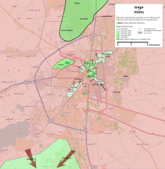
English: Map showing the current strategic situation in Homs as of January 2014.
Red represents area under Government control. Green represents Opposition control. |
||||
| Date | |||||
| Source | Travail personnel | ||||
| Auteur | MrPenguin20 | ||||
| Autres versions |
|


.svg)


.svg)


.svg)


_Territory_Change_2014-2016.gif)

_(within_Northern_Syria).svg)


.png)
.svg)


_map.png)
.svg)


.svg)


Conditions d’utilisation
| Ce travail contient des informations issues de OpenStreetMap mises à disposition sous les termes de la Licence Open Database (ODbL).
L'ODbL n'exige aucune licence en particulier pour les cartes produites à partir de données placées sous l'ODbL. Avant le 1er août 2020, les tuiles des cartes produites par la Fondation OpenStreetMap étaient placées sous la licence CC-BY-SA-2.0. Les cartes produites par d'autres personnes peuvent être placées sous des licences différentes. |
Moi, en tant que détenteur des droits d’auteur sur cette œuvre, je la publie sous la licence suivante :
Ce fichier est disponible selon les termes de la licence Creative Commons Attribution – Partage dans les Mêmes Conditions 3.0 (non transposée).
- Vous êtes libre :
- de partager – de copier, distribuer et transmettre cette œuvre
- d’adapter – de modifier cette œuvre
- Sous les conditions suivantes :
- paternité – Vous devez donner les informations appropriées concernant l'auteur, fournir un lien vers la licence et indiquer si des modifications ont été faites. Vous pouvez faire cela par tout moyen raisonnable, mais en aucune façon suggérant que l’auteur vous soutient ou approuve l’utilisation que vous en faites.
- partage à l’identique – Si vous modifiez, transformez, ou vous basez sur cette œuvre, vous devez distribuer votre contribution sous la même licence ou une licence compatible avec celle de l’original.
Historique du fichier
Cliquer sur une date et heure pour voir le fichier tel qu'il était à ce moment-là.
| Date et heure | Vignette | Dimensions | Utilisateur | Commentaire | |
|---|---|---|---|---|---|
| actuel | 3 août 2018 à 21:35 | | 883 × 900 (4,91 Mio) | Rr016 | Correction: rebels did not control that much north of Homs |
| 10 décembre 2017 à 22:36 |  | 883 × 900 (4,92 Mio) | Kami888 | Made several changes to improve presentation, ask on talk page if any questions. | |
| 9 octobre 2017 à 19:28 |  | 883 × 900 (4,82 Mio) | Rr016 | Fixes: added Shamas district, labeled more districts, fixed date of SAA offensive south of Homs, adjusted Bayada frontlines. | |
| 8 octobre 2017 à 20:07 |  | 883 × 900 (4,82 Mio) | Rr016 | Major overhaul, inspired by Kami88's Battle of Qalamoun.svg layout. Map now shows all territory lost by opposition from 2012 - 2017. Used https://www.facebook.com/the.arab.chronicle/photos/a.454685571308535.1073741828.453010751476017/524550737655351/?t... | |
| 11 mai 2014 à 03:14 |  | 883 × 900 (4,77 Mio) | MrPenguin20 | Updated map to show current areas of control (will update further to show progression of siege). | |
| 21 avril 2014 à 01:02 |  | 883 × 900 (4,77 Mio) | MrPenguin20 | Update following recent offensives. | |
| 8 avril 2014 à 23:14 |  | 883 × 900 (4,77 Mio) | MrPenguin20 | Changed Dar al-Kabirah to contested. | |
| 14 février 2014 à 00:53 |  | 883 × 900 (4,77 Mio) | MrPenguin20 | Updated map in line with https://pbs.twimg.com/media/BgWebW3CcAAJLbS.jpg:large | |
| 4 février 2014 à 17:35 |  | 883 × 900 (4,77 Mio) | MrPenguin20 | Removed "Homs" from center of map. Reworked frontlines in line with map visible at http://online.wsj.com/news/articles/SB10001424052702303277704579346833918268994?mg=reno64-wsj&url=http%3A%2F%2Fonline.wsj.com%2Farticle%2FSB10001424052702303277704579346... | |
| 30 janvier 2014 à 21:09 |  | 883 × 900 (4,77 Mio) | MrPenguin20 | Expanded area of opposition control north of Homs. |
Utilisation du fichier
La page suivante utilise ce fichier :
Usage global du fichier
Les autres wikis suivants utilisent ce fichier :
- Utilisation sur ar.wikipedia.org
- Utilisation sur azb.wikipedia.org
- Utilisation sur be.wikipedia.org
- Utilisation sur cs.wikipedia.org
- Utilisation sur en.wikipedia.org
- Utilisation sur es.wikipedia.org
- Utilisation sur fa.wikipedia.org
- Utilisation sur hu.wikipedia.org
- Utilisation sur it.wikipedia.org
- Utilisation sur ja.wikipedia.org
- Utilisation sur nl.wikipedia.org
- Utilisation sur pl.wikipedia.org
- Utilisation sur ru.wikipedia.org
- Utilisation sur tr.wikipedia.org
- Utilisation sur www.wikidata.org
- Utilisation sur zh.wikipedia.org