
Fichier:Suriname Topography.png

Taille de cet aperçu : 561 × 599 pixels. Autres résolutions : 225 × 240 pixels | 449 × 480 pixels | 719 × 768 pixels | 959 × 1 024 pixels | 1 290 × 1 378 pixels.
Fichier d’origine (1 290 × 1 378 pixels, taille du fichier : 2,8 Mio, type MIME : image/png)
Ce fichier et sa description proviennent de Wikimedia Commons.
Description
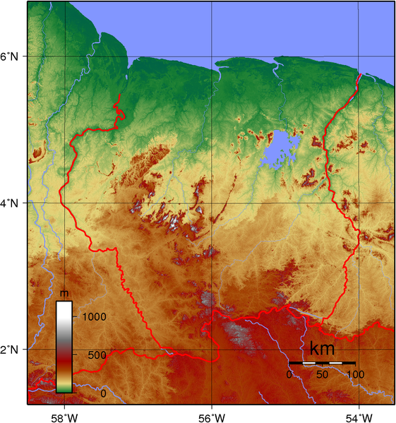
| Description | Topographic map of Suriname. Created with GMT from public domain SRTM data. |
| Date | |
| Source | Travail personnel |
| Auteur | Sadalmelik |
Conditions d’utilisation
| Cette œuvre a été placée dans le domaine public par son auteur, I, Sadalmelik. Ceci s’applique dans le monde entier. Dans certains pays, ceci peut ne pas être possible ; dans ce cas : I, Sadalmelik accorde à toute personne le droit d’utiliser cette œuvre dans n’importe quel but, sans aucune condition, sauf celles requises par la loi. |
Historique du fichier
Cliquer sur une date et heure pour voir le fichier tel qu'il était à ce moment-là.
| Date et heure | Vignette | Dimensions | Utilisateur | Commentaire | |
|---|---|---|---|---|---|
| actuel | 12 juin 2007 à 10:37 | | 1 290 × 1 378 (2,8 Mio) | Sadalmelik | {{Information |Description=Topographic map of Suriname. Created with GMT from oublic domain SRTM data. |Source=self-made |Date=June 12, 2007 |Author= Sadalmelik }} Category:Maps of Suriname [[Category:Topographic maps of the Ameri |
Utilisation du fichier
Les 2 pages suivantes utilisent ce fichier :
Usage global du fichier
Les autres wikis suivants utilisent ce fichier :
- Utilisation sur ar.wikipedia.org
- Utilisation sur ast.wikipedia.org
- Utilisation sur es.wikipedia.org
- Utilisation sur hr.wikipedia.org
- Utilisation sur io.wikipedia.org
- Utilisation sur oc.wikipedia.org
- Utilisation sur pl.wikipedia.org
- Utilisation sur pt.wikibooks.org
- Utilisation sur sh.wikipedia.org
- Utilisation sur uk.wikipedia.org
- Utilisation sur vep.wikipedia.org