
Fichier:T J OBrien Lock and Dam.jpg

Taille de cet aperçu : 800 × 533 pixels. Autres résolutions : 320 × 213 pixels | 640 × 427 pixels | 1 024 × 683 pixels | 1 500 × 1 000 pixels.
Fichier d’origine (1 500 × 1 000 pixels, taille du fichier : 279 kio, type MIME : image/jpeg)
Ce fichier et sa description proviennent de Wikimedia Commons.
| Description |
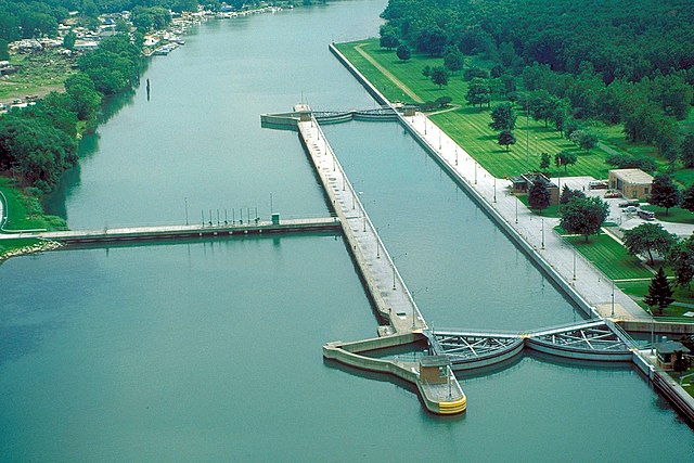
English: Aerial view of T.J. O’Brien Lock and Dam on the Calumet River, which is part of the Illinois Waterway. The dam is situated at river mile 326.5 on the Waterway (326.5 river miles up from the Mississippi River). T.J. O’Brien lock is the uppermost lock on the waterway, and there is not another barrier between the lock and Lake Michigan. There is very little elevation change in the lock, which serves mainly to regulate water flow from Lake Michigan into the waterway. The dam is located in Chicago, Illinois. |
|||
| Date | ||||
| Source |
U.S. Army Corps of Engineers Digital Visual Library Image page Image description page Digital Visual Library home page |
|||
| Auteur | Carol Arney, U.S. Army Corps of Engineers | |||
| Autorisation (Réutilisation de ce fichier) |
|
|||
| Lieu | Chicago, Illinois, USA |
| Lieu de la prise de vue | | Voir cet endroit et d’autres images sur : OpenStreetMap |
|---|
Historique du fichier
Cliquer sur une date et heure pour voir le fichier tel qu'il était à ce moment-là.
| Date et heure | Vignette | Dimensions | Utilisateur | Commentaire | |
|---|---|---|---|---|---|
| actuel | 3 avril 2007 à 02:50 | | 1 500 × 1 000 (279 kio) | DanMS | {{Information | Description = {{en|Aerial view of T. J. O’Brien Lock and Dam on the Calumet River, which is part of the Illinois Waterway. The dam is situated at river mile 326 on the Waterway (326 river miles up from the Mississippi River). T.J. O� |
Utilisation du fichier
Les 2 pages suivantes utilisent ce fichier :
Usage global du fichier
Les autres wikis suivants utilisent ce fichier :
- Utilisation sur arz.wikipedia.org
- Utilisation sur ceb.wikipedia.org
- Utilisation sur de.wikipedia.org
- Utilisation sur en.wikipedia.org
- Utilisation sur eo.wikipedia.org
- Utilisation sur la.wikipedia.org
- Utilisation sur lt.wikipedia.org
- Utilisation sur www.wikidata.org