
Fichier:The Edinburgh Dome - geograph.org.uk - 303213.jpg
The_Edinburgh_Dome_-_geograph.org.uk_-_303213.jpg (640 × 435 pixels, taille du fichier : 236 kio, type MIME : image/jpeg)
Ce fichier et sa description proviennent de Wikimedia Commons.
Description
| Description |
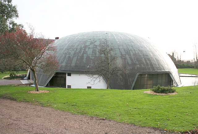
English: The Edinburgh Dome, Imperial Road, Malvern, Worcestershire. The building belongs to Malvern St James School and was built as a sports hall. It was named after the Duke of Edinburgh who opened it in 1978. The sports hall has now moved to a new one on Barnards Green Road. In 2006 the school applied for planning permission to demolish the dome but was turned down. In 2009 the Department of Culture, Media and Sport made the dome a Grade II listed building.
The dome is a concrete parashell and is the only one in the country. It was built by a pioneering technique in which liquid cement was poured onto a special neoprene membrane and then pneumatically inflated; in this case to a height of 11 metres. It took just an hour to complete the inflation and two weeks to complete the building. A moat was built around the base and openings made for doors, windows and for light to reflect off the surrounding water to light the inside of the dome. The parashell was invented by an Italian, Dante Bini, in 1967. The architects here were Godwin and Cowper of Stourport. The construction technique appeared simple, but in fact required a great deal of meticulous planning and seemingly a good deal of luck, which perhaps explains why this structure is still unique in the UK! |
| Date | |
| Source | From geograph.org.uk |
| Auteur | Bob Embleton |
| Attribution (imposé par la licence) | Bob Embleton / The Edinburgh Dome / |
| Lieu de la prise de vue | | Voir cet endroit et d’autres images sur : OpenStreetMap |
|---|
_heading:135.00&language=fr)
| Position de l'objet | | Voir cet endroit et d’autres images sur : OpenStreetMap |
|---|
_heading:135.00&language=fr)
Conditions d’utilisation

|
Cette image provient de la collection du projet Geograph British Isles. Pour obtenir les coordonnées du photographe, veuillez consulter cette page de description de l'image sur le site du projet. Les droits d'auteurs sur cette image sont détenus par Bob Embleton ; l'image est placée sous une licence Creative Commons avec mention de paternité et partage à l'identique (CC-By-SA) en version 2.0.
|
- Vous êtes libre :
- de partager – de copier, distribuer et transmettre cette œuvre
- d’adapter – de modifier cette œuvre
- Sous les conditions suivantes :
- paternité – Vous devez donner les informations appropriées concernant l'auteur, fournir un lien vers la licence et indiquer si des modifications ont été faites. Vous pouvez faire cela par tout moyen raisonnable, mais en aucune façon suggérant que l’auteur vous soutient ou approuve l’utilisation que vous en faites.
- partage à l’identique – Si vous modifiez, transformez, ou vous basez sur cette œuvre, vous devez distribuer votre contribution sous la même licence ou une licence compatible avec celle de l’original.
Historique du fichier
Cliquer sur une date et heure pour voir le fichier tel qu'il était à ce moment-là.
| Date et heure | Vignette | Dimensions | Utilisateur | Commentaire | |
|---|---|---|---|---|---|
| actuel | 23 décembre 2010 à 00:42 | | 640 × 435 (236 kio) | GeographBot | == {{int:filedesc}} == {{Information |description={{en|1=The Edinburgh Dome The Edinburgh Dome, off Imperial Road, is owned by Malvern St James School and was built as a sports hall. It was named after the Duke of Edinburgh who opened it in 1978. The spor |
Utilisation du fichier
Les 2 pages suivantes utilisent ce fichier :
Usage global du fichier
Les autres wikis suivants utilisent ce fichier :
- Utilisation sur arz.wikipedia.org
- Utilisation sur nl.wikipedia.org