
Fichier:Treblinka II aerial photo (1944).jpg
Fichier d’origine (1 000 × 890 pixels, taille du fichier : 704 kio, type MIME : image/jpeg)
Ce fichier et sa description proviennent de Wikimedia Commons.
.jpg?uselang=fr)
| Description |
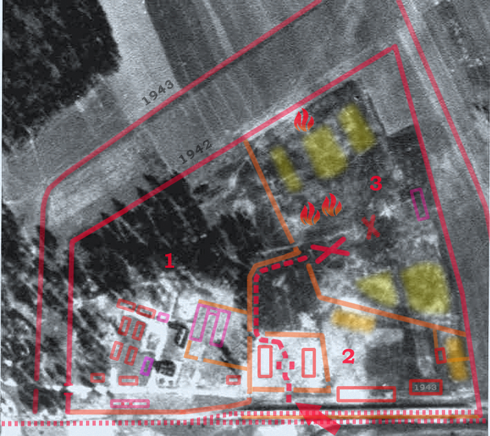
English: Treblinka II extermination camp of the Operation Reinhard in German-occupied Poland. Aerial photograph of the camp perimeter taken in 1944; several months after the dismantling of the camp. All known structrures are gone except for the farmhouse built within it and lifestock shed (lower left). The photograp is overlayed with the known structures as described on the map of Treblinka drawn by Mr. Peter Laponder, builder of the Treblinka Model at the new Cape Town Holocaust Center, digitized by ARC and made available at the Mapping Treblinka webpage. On the left hand side, the color outlines show dismantled SS and Hiwi guards living quarters with most barracks clearly defined by the surrounding walkways. The railway unloading platform (lower centre) consisted of two parallel ramps visible in the bottom, marked with the red arrow. Location of new expanded gass chambers marked with a cross. Undressing barracks and sorting yard (separate for men and women with hair-cropping area) marked with two rectangles surrounded by solid fence with no view of the outside. The adjacent "Sluice" through the woods separated by barb-wire fence, marked with red dashed-line. Polski: Zdjęcie lotnicze przedstawiające teren, na którym w okresie od lipca 1942 roku do listopada 1943 roku istniał niemiecki nazistowski obóz zagłady Treblinka II. Zdjęcie wykonano w 1944 roku, już po likwidacji obozu i zatarciu śladów jego istnienia. Widać na nim zabudowania „farmy”, na której Niemcy osiedlili dwóch ukraińskich wachmanów z zadaniem strzeżenia terenu poobozowego (u dołu, po lewej stronie). Na zdjęciu przy pomocy kolorowych konturów i innych znaków zaznaczono granice obozu, wewnętrzne ogrodzenia oraz miejsca, gdzie znajdowały się najważniejsze obiekty. Cyframi od 1 do 3 oznaczono strefy obozowe.
Source: Aerial Photos from the National Archives, Washington DC. Ref. No. GX 12225 SG, exp. 259.1) Strefa administracyjno-mieszkalna 2) Strefa przyjęć 3) Obszar zagłady (Totenlager) |
| Date | Before November 1944 (either September or October, according to different sources), roughly one month after the Soviet Army took over the area from under the Nazis. |
| Source | National Archives and Records Administration (ARC 2005) or much larger scan (CODOH) with greatly reduced contrast. Original from the National Archives Air Photo library at Alexandria, Virginia, U.S.A. Cartographic Division (Record Group 373). Some 1.2 million Nazi German air photographs were released into the public domain in the 1970s and 1980s by the National Archives. Numerous authors laid claims to have published them for the first time ever, notably the Holocaust denier and author John C. Ball (Air Photo Evidence)[1] and Udo Walendy (Der Fall Treblinka) before him. |
| Auteur | Auteur inconnu, overlay legend in Photoshop by Poeticbent |
| Autorisation (Réutilisation de ce fichier) |
PD-Polish and EU |
Cette image est placée dans le domaine public parce que, selon l'article 3 de la loi sur le droit d'auteur du 29 mars 1926 de la Republique de Pologne et l'article 2 de la loi sur le droit d'auteur du 10 juillet 1952 de la République populaire de Pologne, toutes les photographies d'auteurs polonais (ou publiées pour la première fois en Pologne, ou publiées simultanément en Pologne et dans un autre pays) publiées sans spécification claire des droits d'auteur afférents avant le changement de régime juridique introduit par la loi du 23 mai 1994 sur le droit d'auteur sont considérées comme faisant partie du domaine public.
Cette œuvre est dans le domaine public aux États-Unis car elle remplit trois conditions :
À l'attention des personnes déposant de telles images sur le serveur : merci de fournir les informations sur la date et le lieu de première publication de ces images.
|
 |
| Moi, propriétaire des droits d’auteur sur cette œuvre, la place dans le domaine public. Ceci s'applique dans le monde entier. Dans certains pays, ceci peut ne pas être possible ; dans ce cas : J’accorde à toute personne le droit d’utiliser cette œuvre dans n’importe quel but, sans aucune condition, sauf celles requises par la loi. |
Historique du fichier
Cliquer sur une date et heure pour voir le fichier tel qu'il était à ce moment-là.
| Date et heure | Vignette | Dimensions | Utilisateur | Commentaire | |
|---|---|---|---|---|---|
| actuel | 19 décembre 2013 à 19:42 | | 1 000 × 890 (704 kio) | Poeticbent | missing barbed-wire fencing |
| 18 août 2013 à 21:20 |  | 1 000 × 890 (676 kio) | Poeticbent | {{Information |Description={{en|1=Treblinka II extermination camp of the Operation Reinhard in occupied Poland. Aerial photograph of the camp perimeter taken in 1944; several months after the dismantling of the camp. All known structrures are gone exce... |
Utilisation du fichier
La page suivante utilise ce fichier :
Usage global du fichier
Les autres wikis suivants utilisent ce fichier :
- Utilisation sur el.wikipedia.org
- Utilisation sur en.wikipedia.org
- Utilisation sur he.wikipedia.org
- Utilisation sur it.wikipedia.org
- Utilisation sur ja.wikipedia.org
- Utilisation sur ml.wikipedia.org
- Utilisation sur pl.wikipedia.org
- Utilisation sur vi.wikipedia.org
- Utilisation sur zh.wikipedia.org
.jpg)