
Fichier:Vesta map for GeoHack.png

Taille de cet aperçu : 800 × 400 pixels. Autres résolutions : 320 × 160 pixels | 640 × 320 pixels | 1 024 × 512 pixels | 1 280 × 640 pixels | 3 561 × 1 781 pixels.
Fichier d’origine (3 561 × 1 781 pixels, taille du fichier : 3,06 Mio, type MIME : image/png)
Ce fichier et sa description proviennent de Wikimedia Commons.
Description
| Description |
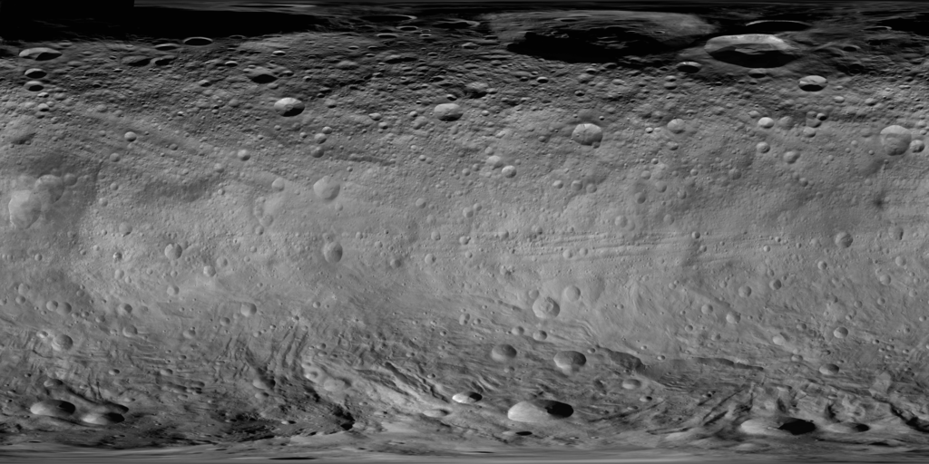
English: Global photomap of asteroid 4 Vesta, based on the Dawn spacecraft's framing camera (FC) imagery. North is up. Image covers 90 degrees north to 90 degrees south; left edge is 330 degrees longitude, with 0 degrees longitude just to the right. For feature names and exact lines of latitude and longitude, see Map of Vesta with feature names.png. For image information, see: Roatsch, Th.; Kersten, E.; Matz, K.-D.; Preusker, F.; Scholten, F.; Jaumann, R.; Raymond, C.A.; Russell, C.T. (December 2012). "High resolution Vesta High Altitude Mapping Orbit (HAMO) Atlas derived from Dawn framing camera images". Planetary and Space Science 73 (1): 283-286. DOI:10.1016/j.pss.2012.08.021. The Vesta cartographic coordinate system used in this map has been recommended by the IAU. |
| Date | vers 2012 |
| Source | https://planetarynames.wr.usgs.gov/Page/VESTA/target / https://planetarynames.wr.usgs.gov/images/vesta.pdf |
| Auteur | NASA/JPL-Caltech/UCLA/MPS/DLR/IDA |
| Autres versions | Original upload by Stepheng3 based on 589450main pia14703-full full.jpg (resized, filled northern hemisphere, and converted to PNG). |
Conditions d’utilisation
| Ce fichier provient de la NASA. Sauf exception, les documents créés par la NASA ne sont pas soumis à copyright. Pour plus d'informations, voir la politique de copyright de la NASA. | ||
 |
Attention :
|
Historique du fichier
Cliquer sur une date et heure pour voir le fichier tel qu'il était à ce moment-là.
| Date et heure | Vignette | Dimensions | Utilisateur | Commentaire | |
|---|---|---|---|---|---|
| actuel | 22 décembre 2019 à 09:09 | | 3 561 × 1 781 (3,06 Mio) | Huntster | Specifically uploading over previous image so that the templates that call on this image for mapping purposes can utilize this higher resolution map. |
| 22 décembre 2011 à 23:57 |  | 720 × 360 (170 kio) | Stepheng3 | == {{int:filedesc}} == {{Information |Description={{en|1=A global photomap of asteroid 4 Vesta, based on DAWN probe framing camera imagery. The south pole is at bottom edge, the equator is above the bright, smooth band of troughs in upper middle part.}} | |
Utilisation du fichier
Les 6 pages suivantes utilisent ce fichier :
Usage global du fichier
Les autres wikis suivants utilisent ce fichier :
- Utilisation sur en.wikipedia.org