Fichier:Warren Map of the Territory of the United States from the Mississippi to the Pacific Ocean 1857 UTA.jpg

Le contenu de la page n’est pas pris en charge dans d’autres langues.
Une page de Wikipédia, l'encyclopédie libre.

Fichier d’origine(1 024 × 943 pixels, taille du fichier : 434 kio, type MIME : image/jpeg)

Ce fichier et sa description proviennent de Wikimedia Commons.

Description

Titre
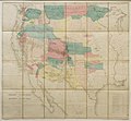
English: Map of the Territory of the United States from the Mississippi to the Pacific Ocean
Description
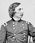
English: U.S. Army Topographical Engineer Lieutenant Gouverneur K. Warren's map of the trans-Mississippi west is considered one of the great cartographic accomplishments of the nineteenth century. It was a synthesis of the most important maps of the area from about 1810 to 1857. Warren (1830-1882), later a Brigadier General and hero of the Battle of Gettysburg, constructed the map over a period of four years and wrote an approximately 100-page "Memoir" to accompany it. He consulted the maps of virtually every U.S. government-sponsored expedition in the west, from Lewis and Clark in 1804-1806 to the more recent exploring expeditions for the U.S. Pacific Railroad Surveys and the U.S.-Mexico Boundary Surveys. Warren also included their survey routes on his map and noted existing U.S. Army forts or posts. The combined map helped the government authorities then determine areas needing further exploration. For example, a vast stretch of the southern Utah Territory is labeled "Unexplored". By the time the map was published in 1857 new expeditions were already on their way there.

This example is divided by military districts, uses red flags or guidons to emphasize the U.S. Army's forts or posts, and is hand-colored in delicateshades of yellow, pink, and blue to show vast stretches of territory still largely dominated by specific Native American tribes. Military planners could have used this example to plot their next campaigns or to determine possible locations for new forts.

It is important to note that despite its large size, Warren's map does not show as much detail as the almost equally large U.S. Army Topographical Engineers' Map of Texas (cat. no. 61), which had less area to portray.
Date
Source UTA Libraries Cartographic Connections: carte / texte
Créé par
Gouverneur Kemble Warren  (1830–1882)  wikidata:Q1460144
 
Gouverneur Kemble Warren
Autres noms
Nom de naissance : Gouverneur Kemble Warren; Gouverneur K. Warren
Description officier, ingénieur civil, ingénieur ou ingénieure, écrivain ou écrivaine et botaniste américain
Date de naissance / décès 8 janvier 1830 Éditer sur Wikidata 8 août 1882 Éditer sur Wikidata
Lieu de naissance / décès Cold Spring Newport
Autorité
creator QS:P170,Q1460144
Edwin Freyhold
F. W. von Egloffstein  (1824–1898)  wikidata:Q101854
 
F. W. von Egloffstein
Autres noms
F. W., Baron Von Egloffstein; F. W. von Eggloffstein; F. W. von Egloffstein; F. W. Von Egloffstein; Frederick W. Von Egloffstein; F.W. von Egloffstein; Frederick Wilhelm von Egloffstein
Description dessinateur ou dessinatrice américano-allemand
Date de naissance / décès 18 mai 1824 Éditer sur Wikidata 1898 Éditer sur Wikidata
Lieu de naissance / décès Altdorf bei Nürnberg Grand Londres
Autorité
creator QS:P170,Q101854
Attribution de l’acquisition
English: UTA Libraries Special Collections, Gift of Virginia Garrett
 Données géotemporelles
Lieu États-Unis
Géoréférencement Géoréférencer la carte dans Wikimaps Warper Si c'est inapproprié, définissez warp_status = skip pour masquer.
 Données bibliographiques
Lieu de publication Washington
Imprimé par
United States War Department
 Données d'archives
institution QS:P195,Q1230739
Dimensions hauteur : 111 cm ; largeur : 121 cm
dimensions QS:P2048,111U174728
dimensions QS:P2049,121U174728
Technique / matériaux lithographie colorée sur papier
lithographie colorée sur toile
artwork-references

Warren, Gouverneur K. (1855-1860) «Memoir to Accompany the Map of the Territory of the United States from the Mississippi River to the Pacific Ocean...» dans Explorations and Surveys for a Railroad Route from the Mississippi River to the Pacific Ocean, 11, Washington : U.S. War Department, pp. 7−115

Huseman, Ben W. The Price of Manifest Destiny, nº67 , p. 33


Conditions d’utilisation

Public domain

L’auteur est mort en 1885 ; cette œuvre est donc également dans le domaine public dans tous les pays pour lesquels le droit d’auteur a une durée de vie de 100 ans ou moins après la mort de l’auteur.


Cette œuvre est dans le domaine public aux États-Unis car elle a été publiée avant le 1er janvier 1929.

Légendes

Ajoutez en une ligne la description de ce que représente ce fichier

Éléments décrits dans ce fichier

dépeint

40 millimètre

image/jpeg

Historique du fichier

Cliquer sur une date et heure pour voir le fichier tel qu'il était à ce moment-là.

Date et heureVignetteDimensionsUtilisateurCommentaire
actuel15 mars 2022 à 20:53Vignette pour la version du 15 mars 2022 à 20:531 024 × 943 (434 kio)Michael Barera== {{int:filedesc}} == {{Map |title = {{en|'''''Map of the Territory of the United States from the Mississippi to the Pacific Ocean'''''}} |description = {{en|U.S. Army Topographical Engineer Lieutenant Gouverneur K. Warren's map of the trans-Mississippi west is considered one of the great cartographic accomplishments of the nineteenth century. It was a synthesis of the most important maps of the area from about 1810 to 1857. Warren (1830-1882), later a Brigadier General a...

La page suivante utilise ce fichier :

Usage global du fichier

Les autres wikis suivants utilisent ce fichier :

Métadonnées