
Fichier:Waterpocket Fold - Looking south from the Strike Valley Overlook.jpg
Pas de plus haute résolution disponible.
Waterpocket_Fold_-_Looking_south_from_the_Strike_Valley_Overlook.jpg (800 × 600 pixels, taille du fichier : 592 kio, type MIME : image/jpeg)
Ce fichier et sa description proviennent de Wikimedia Commons.
| Description |
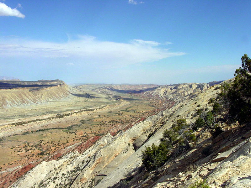
English: Perhaps the most amazing view in the region is this scene looking south from the Strike Valley Overlook along a great, warping arc in the greater Waterpocket Fold. The scene encompasses about a 2 kilometer thick section of sedimentary rocks and landscape features representing more than 200 million years of earth surface processes and conditions. The oldest sedimentary rocks on the right (the Navajo Sandstone) represents a great blanket of desert dunes that extended across the region at the close of Triassic time. Morrison Formation in the center represents the changes in Jurassic time when the great dune fields gave way to coastal floodplains, swamps, and shallow inland seas. The Mancos Shale represents the formation of a great inland Western Interior Seaway that lasted in the region through almost all of Cretaceous time. Finally this seaway withdrew at the close of Cretaceous time, the land rose, and volcanoes of the Henry Mountains formed in early Tertiary time (probably during the Oligocene Epoch between 37 and 24 million years ago). Since middle Tertiary time, the land has been steadily rising and eroding, perhaps at an increasing rate with the development of the modern Colorado River system across the region. |
|||
| Date | 8 août 2003 (d'après les données Exif) | |||
| Source | USGS – 3dparks.wr.usgs.gov | |||
| Auteur | Auteur inconnu | |||
| Autorisation (Réutilisation de ce fichier) |
|
Historique du fichier
Cliquer sur une date et heure pour voir le fichier tel qu'il était à ce moment-là.
| Date et heure | Vignette | Dimensions | Utilisateur | Commentaire | |
|---|---|---|---|---|---|
| actuel | 16 mars 2006 à 05:05 | | 800 × 600 (592 kio) | Mav | USGS image from [http://3dparks.wr.usgs.gov/capitol2/html/3d4665.html] Perhaps the most amazing view in the region is this scene looking south from the Strike Valley Overlook along a great, warping arc in the greater Waterpocket Fold. The scene encompass |
Utilisation du fichier
La page suivante utilise ce fichier :
Usage global du fichier
Les autres wikis suivants utilisent ce fichier :
- Utilisation sur ar.wikipedia.org
- Utilisation sur bg.wikipedia.org
- Utilisation sur en.wikipedia.org
- Utilisation sur es.wikipedia.org
- Utilisation sur gl.wikipedia.org
- Utilisation sur ja.wikipedia.org
- Utilisation sur lt.wikipedia.org
- Utilisation sur tr.wikipedia.org