
Fichier:1995 Atlantic hurricane season summary map.png

Taille de cet aperçu : 800 × 495 pixels. Autres résolutions : 320 × 198 pixels | 640 × 396 pixels | 1 024 × 634 pixels | 1 280 × 792 pixels | 2 560 × 1 585 pixels | 4 000 × 2 476 pixels.
Fichier d’origine (4 000 × 2 476 pixels, taille du fichier : 6,37 Mio, type MIME : image/png)
Ce fichier et sa description proviennent de Wikimedia Commons.
| Description |
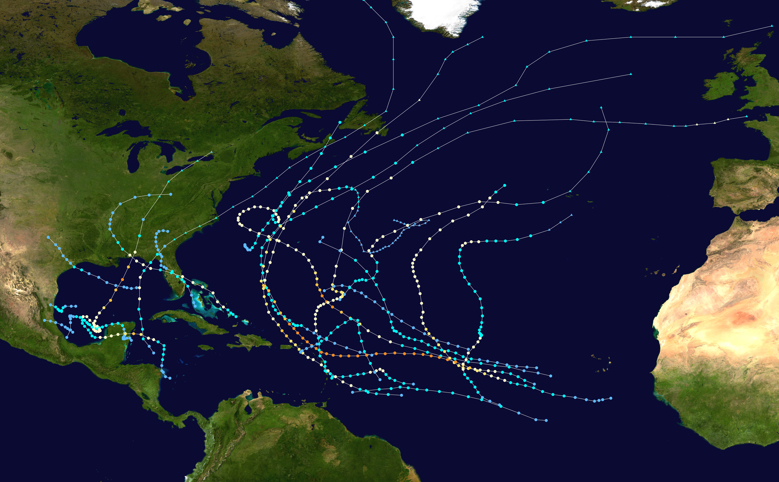
English: This map shows the tracks of all tropical cyclones in the 1995 Atlantic hurricane season. The points show the location of each storm at 6-hour intervals. The colour represents the storm's maximum sustained wind speeds as classified in the Saffir-Simpson Hurricane Scale (see below), and the shape of the data points represent the type of the storm.
Tropical depression (≤38 mph, ≤62 km/h)
Tropical storm (39–73 mph, 63–118 km/h)
Category 1 (74–95 mph, 119–153 km/h)
Category 2 (96–110 mph, 154–177 km/h)
Category 3 (111–129 mph, 178–208 km/h)
Category 4 (130–156 mph, 209–251 km/h)
Category 5 (≥157 mph, ≥252 km/h)
Unknown
Storm type |
| Source | Created using Wikipedia:WikiProject Tropical cyclones/Tracks. The background image is from NASA [1]. The tracking data is from the National Hurricane Center's Atlantic hurricane database |
| Auteur | Supportstorm |

|
Ce fichier peut être mis à jour pour contenir de nouvelles informations. Si vous voulez utiliser une version spécifique de ce fichier sans que les mises à jour ne s’affichent, merci d’importer la version en question dans un fichier séparé. |
| Cette œuvre a été placée dans le domaine public par son auteur, Supportstorm. Ceci s’applique dans le monde entier. Dans certains pays, ceci peut ne pas être possible ; dans ce cas : Supportstorm accorde à toute personne le droit d’utiliser cette œuvre dans n’importe quel but, sans aucune condition, sauf celles requises par la loi. |
Historique du fichier
Cliquer sur une date et heure pour voir le fichier tel qu'il était à ce moment-là.
| Date et heure | Vignette | Dimensions | Utilisateur | Commentaire | |
|---|---|---|---|---|---|
| actuel | 28 janvier 2020 à 05:33 | | 4 000 × 2 476 (6,37 Mio) | Supportstorm | Standard dimensions |
| 9 juin 2013 à 20:52 |  | 3 000 × 1 854 (4,27 Mio) | Supportstorm | {{Hurricane season auto track map|start=|end=|source=ATL|type=hurricane|basin=Atlantic|year=1995|author=Supportstorm}} |
Utilisation du fichier
La page suivante utilise ce fichier :
Usage global du fichier
Les autres wikis suivants utilisent ce fichier :
- Utilisation sur de.wikipedia.org
- Utilisation sur en.wikipedia.org
- Hurricane Opal
- 1995 Atlantic hurricane season
- Hurricane Roxanne
- Hurricane Luis
- Hurricane Marilyn
- Hurricane Erin (1995)
- Hurricane Allison (1995)
- Template:1995 Atlantic hurricane season buttons
- Hurricane Felix (1995)
- Tropical Storm Jerry (1995)
- Hurricane Iris (1995)
- Tropical Storm Gabrielle (1995)
- Tropical Storm Dean (1995)
- Hurricane Tanya
- Timeline of the 1995 Atlantic hurricane season
- Meteorological history of Hurricane Luis
- User:TheAustinMan/sandbox/Hurricane Opal
- User:Khaled98/1995 hurricane reanalysis
- Utilisation sur es.wikipedia.org
- Utilisation sur he.wikipedia.org
- Utilisation sur ta.wikipedia.org