
Fichier:Homann Planiglobii Terrestris Cumutroq Hemisphaerio Caelesti Generalis Exhibitio 1707 UTA.jpg

Taille de cet aperçu : 692 × 599 pixels. Autres résolutions : 277 × 240 pixels | 554 × 480 pixels | 887 × 768 pixels | 1 182 × 1 024 pixels | 2 364 × 2 048 pixels | 3 103 × 2 688 pixels.
Fichier d’origine (3 103 × 2 688 pixels, taille du fichier : 2,35 Mio, type MIME : image/jpeg)
Ce fichier et sa description proviennent de Wikimedia Commons.
Description
| Titre |
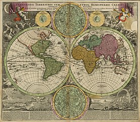
Latina: Planiglobii Terrestris cum Utroq Hemisphaerio Caelesti Generalis Exhibitio... |
||||||||||||||||||||||||||
| Description |
English: This double-hemisphere world map features insets of the celestial northern hemisphere and the celestial southern hemisphere, both of which show the mythological figures and objects of the constellations. Windheads and illustrations of a volcanic eruption, earthquake, tides, water-spouts, and a rainbow decorate the four corners of the composition. The map shows California as insular and traces the sailing routes of the explorers Magellan, Olivier van Noort, William Dampier, Abel Tasman, and Juan Gaetano.
Nuremberg cartographer and map publisher Homann and his family later produced a number of celestial and selenographical (lunar) charts in conjunction with the Nuremberg astronomer and mathematician Johann Gabriel Doppelmayr (1677-1750). Many of these charts were featured in Doppelmayr's Atlas coelestis, which Homann's Heirs published in 1742. |
||||||||||||||||||||||||||
| Date | |||||||||||||||||||||||||||
| Source | UTA Libraries Cartographic Connections: carte / texte | ||||||||||||||||||||||||||
| Créé par |
|
||||||||||||||||||||||||||
| Attribution de l’acquisition |
English: UTA Libraries Special Collections, Gift of Virginia Garrett |
||||||||||||||||||||||||||
| Géoréférencement | Si c'est inapproprié, définissez warp_status = skip pour masquer. | ||||||||||||||||||||||||||
| Données bibliographiques | |||||||||||||||||||||||||||
| Publication |
Atlas Novus Terrarum Orbis Imperia |
||||||||||||||||||||||||||
| Auteur |
|
||||||||||||||||||||||||||
| Lieu de publication | Nuremberg | ||||||||||||||||||||||||||
| Éditeur de publication |
|
||||||||||||||||||||||||||
| Données d'archives | |||||||||||||||||||||||||||
| Collection |
|
||||||||||||||||||||||||||
| Dimensions | hauteur : 49 cm ; largeur : 57,2 cm | ||||||||||||||||||||||||||
| Technique / matériaux | gravure colorée | ||||||||||||||||||||||||||
| artwork-references |
Moreland et Bannister. "Homann Heirs". Error: journal= not stated. Warner, Deborah J. (1979) The Sky Explored: Celestial Cartography 1500-1800, New York : Alan R. Liss, Inc., p. 120 |
||||||||||||||||||||||||||
.jpg)
Conditions d’utilisation

|
This file was provided to Wikimedia Commons by the University of Texas at Arlington Libraries as part of a cooperation project. The University of Texas at Arlington Libraries is part of the University of Texas at Arlington, a public research university located in Arlington, Texas.
|
|
L’auteur est mort en 1724 ; cette œuvre est donc également dans le domaine public dans tous les pays pour lesquels le droit d’auteur a une durée de vie de 100 ans ou moins après la mort de l’auteur. Cette œuvre est dans le domaine public aux États-Unis car elle a été publiée avant le 1er janvier 1929. | |
| Ce fichier a été identifié comme étant exempt de restrictions connues liées au droit d’auteur, y compris tous les droits connexes et voisins. | |
Historique du fichier
Cliquer sur une date et heure pour voir le fichier tel qu'il était à ce moment-là.
| Date et heure | Vignette | Dimensions | Utilisateur | Commentaire | |
|---|---|---|---|---|---|
| actuel | 10 février 2022 à 23:22 | | 3 103 × 2 688 (2,35 Mio) | Michael Barera | == {{int:filedesc}} == {{Map |title = {{la|'''''laniglobii Terrestris cum Utroq Hemisphaerio Caelesti Generalis Exhibitio...'''''}} |description = {{en|This double-hemisphere world map features insets of the celestial northern hemisphere and the celestial southern hemisphere, both of which show the mythological figures and objects of the constellations. Windheads and illustrations of a volcanic eruption, earthquake, tides, water-spouts, and a rainbow decorate the four corn... |
Utilisation du fichier
Les 2 pages suivantes utilisent ce fichier :
Usage global du fichier
Les autres wikis suivants utilisent ce fichier :
- Utilisation sur de.wikipedia.org
- Utilisation sur en.wikipedia.org
- Utilisation sur es.wikipedia.org
- Utilisation sur fa.wikipedia.org
- Utilisation sur id.wikipedia.org
- Utilisation sur la.wikipedia.org
- Utilisation sur nl.wikipedia.org
- Utilisation sur pt.wikipedia.org
- Utilisation sur ro.wikipedia.org
- Utilisation sur ru.wikipedia.org
- Utilisation sur sr.wikipedia.org
- Utilisation sur sv.wikipedia.org
- Utilisation sur uk.wikipedia.org