
Fichier:Illa de Xàtiva millorat.jpg

Taille de cet aperçu : 800 × 596 pixels. Autres résolutions : 320 × 238 pixels | 640 × 477 pixels | 1 024 × 763 pixels | 1 280 × 953 pixels | 1 740 × 1 296 pixels.
Fichier d’origine (1 740 × 1 296 pixels, taille du fichier : 927 kio, type MIME : image/jpeg)
Ce fichier et sa description proviennent de Wikimedia Commons.
Description
| Description |
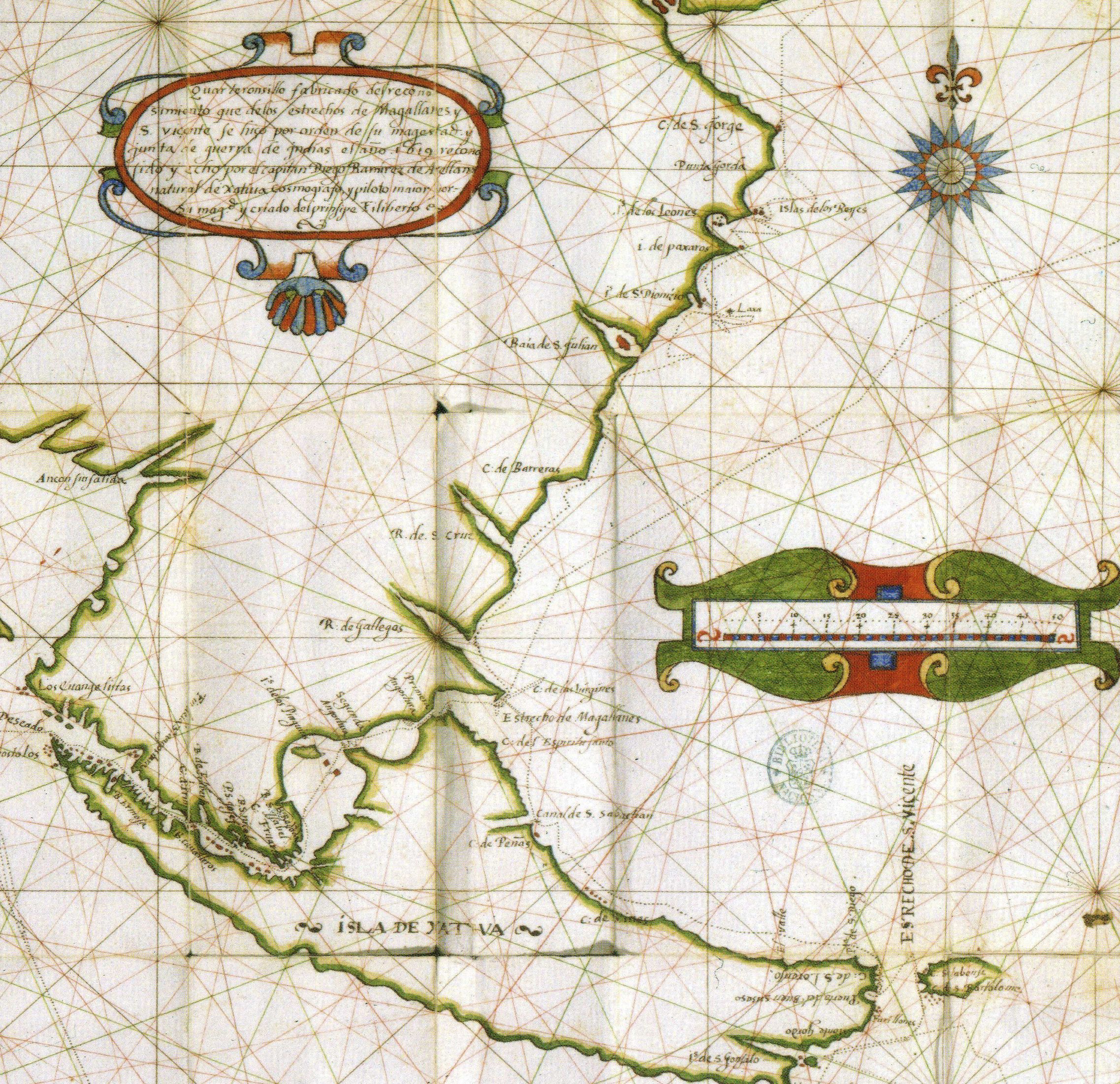
Català: Mapa de Diego Ramírez de Arellano amb l'Illa de Xàtiva i part de la Patagònia. |
| Date | |
| Source | http://www.histo.cat/1/illa_de_xativa3.jpg |
| Auteur | ca:Diego Ramírez de Arellano |
| Autorisation (Réutilisation de ce fichier) |
Multi-license CC-BY-SA-3.0 and GFDL |
| Autres versions | Illa de Xàtiva |
Conditions d’utilisation
| Moi, propriétaire des droits d’auteur sur cette œuvre, la place dans le domaine public. Ceci s'applique dans le monde entier. Dans certains pays, ceci peut ne pas être possible ; dans ce cas : J’accorde à toute personne le droit d’utiliser cette œuvre dans n’importe quel but, sans aucune condition, sauf celles requises par la loi. |
Historique du fichier
Cliquer sur une date et heure pour voir le fichier tel qu'il était à ce moment-là.
| Date et heure | Vignette | Dimensions | Utilisateur | Commentaire | |
|---|---|---|---|---|---|
| actuel | 24 mai 2019 à 08:43 | | 1 740 × 1 296 (927 kio) | JuTa | The other one is still available at File:Illa de Xàtiva.jpg |
| 20 mai 2019 à 09:16 |  | 2 275 × 2 203 (1,5 Mio) | Mcapdevila | Reverted to version as of 17:30, 22 July 2015 (UTC) | |
| 14 décembre 2016 à 06:46 |  | 1 740 × 1 296 (927 kio) | JuTa | The other one is available at File:Illa de Xàtiva.jpg | |
| 22 juillet 2015 à 19:30 |  | 2 275 × 2 203 (1,5 Mio) | Mcapdevila | Map in color of Diego Ramírez de Arellano depicting the actual Island of Tierra de Fuego with the name of Tierra de Xàtiva, after he did circumnavigated an chartered the whole island for the very first time | |
| 24 décembre 2007 à 20:24 |  | 1 740 × 1 296 (927 kio) | Socarrat~commonswiki | {{Information |Description= |Source= |Date= |Author= |Permission= |other_versions= }} |
Utilisation du fichier
Les 2 pages suivantes utilisent ce fichier :