
Fichier:London-geographical-institute the-peoples-atlas 1920 the-partition-of-russia-in-europe 3012 3992 600.jpg

Taille de cet aperçu : 452 × 599 pixels. Autres résolutions : 181 × 240 pixels | 362 × 480 pixels | 579 × 768 pixels | 772 × 1 024 pixels | 1 545 × 2 048 pixels | 3 012 × 3 992 pixels.
Fichier d’origine (3 012 × 3 992 pixels, taille du fichier : 2,31 Mio, type MIME : image/jpeg)
Ce fichier et sa description proviennent de Wikimedia Commons.
Description
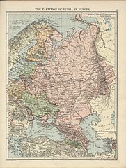
| Description | Partition of Russia in Europe (fall of the Russian Empire), from London Geographical Institute - The Peoples Atlas - 1920. |
| Date | |
| Source | [1] |
| Auteur | |
| Autorisation (Réutilisation de ce fichier) |
Public Domain due to age |
| Autres versions |


Conditions d’utilisation
Ce document est dans le domaine public aux États-Unis. Ceci s'applique aux travaux des États-Unis où le copyright a expiré, souvent parce que sa première publication s'est produite avant le 1er janvier 1929. Voir cette page pour davantage d'explication.
|
 | |
 |
Cette image peut ne pas être dans le domaine public en dehors des États-Unis (ceci s'applique particulièrement au Canada, en Chine (pas Hong Kong, Macao, ni Taïwan), en Allemagne ou en Suisse). Le créateur et l'année de la publication sont l'information essentielle et doivent être fournis.
|
Historique du fichier
Cliquer sur une date et heure pour voir le fichier tel qu'il était à ce moment-là.
| Date et heure | Vignette | Dimensions | Utilisateur | Commentaire | |
|---|---|---|---|---|---|
| actuel | 9 juillet 2007 à 23:09 | | 3 012 × 3 992 (2,31 Mio) | Piotrus | {{Information |Description=Partition of Russia in Europe (fall of the Russian Empire), from London Geographical Institute - The Peoples Atlas - 1920. |Source=[http://www.hipkiss.org/data/maps/london-geographical-institute_the-peoples-atlas_1920_poland-an |
Utilisation du fichier
La page suivante utilise ce fichier :
Usage global du fichier
Les autres wikis suivants utilisent ce fichier :
- Utilisation sur be.wikipedia.org
- Utilisation sur ca.wikipedia.org
- Utilisation sur cs.wikipedia.org
- Utilisation sur et.wikipedia.org
- Utilisation sur lt.wikipedia.org
- Utilisation sur lt.wikibooks.org
- Utilisation sur sr.wikipedia.org
- Utilisation sur tg.wikipedia.org
- Utilisation sur uk.wikipedia.org