
Fichier:MGS MOC Wide Angle Map of Mars PIA03467.jpg

Fichier d’origine (2 000 × 1 288 pixels, taille du fichier : 534 kio, type MIME : image/jpeg)
Ce fichier et sa description proviennent de Wikimedia Commons.
Description
| Description |
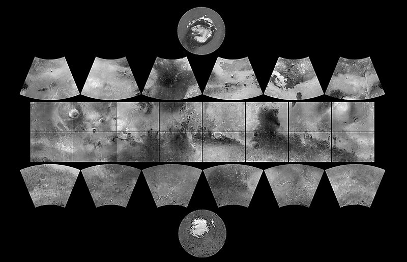
English: The MGS MOC Wide Angle Map of Mars
In 1979, NASA published ATLAS OF MARS: THE 1:5,000,000 MAP SERIES, edited by R.M. Batson, P.M. Bridges, and J.L. Inge, of the U.S. Geological Survey in Flagstaff, Arizona. This was a compendium of airbrushed shaded relief maps, controlled photomosaics, and in a few cases albedo (shading) maps, mostly assembled from Mariner 9 survey images, with some gaps filled by Viking orbiter images. The planet was divided into thirty "quadrangles" or areas, each with an "Mars Chart" or "MC" number (MC-1 through MC-30). The equatorial region was portrayed in the Mercator projection, with Lambert Conformal Conic for the mid-latitudes and Polar Stereographic for the poles. Although digital products such as the Mars Digital Image Mosaic (MDIM) and various Mars Global Surveyor (MGS) Mars Orbiter Laser Altimeter (MOLA) maps have partially supplanted the ATLAS, it remains a standard desktop reference today. In 1999, the Mars Orbiter Camera (MOC) aboard the MGS orbiter acquired a global stereo image dataset using its red-filter Wide Angle Camera. We have recently completed a 256 pixel/degree (about 230 meters/pixel) mosaic of these images using software developed at Malin Space Science Systems(MSSS). Visit the MSSS Geodesy Campaign Mosaic Page to access both partial and full-resolution mosaics in Planetary Data System format. The image above is a reproduction of the new MGS MOC Mars Digital Map and is the first of several cartographic products that MSSS expects to release this year. Malin Space Science Systems and the California Institute of Technology built the MOC using spare hardware from the Mars Observer mission. MSSS operates the camera from its facilities in San Diego, CA. The Jet Propulsion Laboratory's Mars Surveyor Operations Project operates the Mars Global Surveyor spacecraft with its industrial partner, Lockheed Martin Astronautics, from facilities in Pasadena, CA and Denver, CO. |
| Date | (addition date) |
| Source | http://photojournal.jpl.nasa.gov/catalog/PIA03467 (image link) |
| Auteur | NASA/JPL/MSSS |
Cette image ou vidéo a été cataloguée par le Jet Propulsion Lab de la National Aeronautics and Space Administration (NASA) des États-Unis sous Photo ID : PIA03467.Ce bandeau n’indique rien sur le statut de l’œuvre au regard du droit d'auteur. Un bandeau de droit d’auteur est requis. Voir Commons:À propos des licences pour plus d’informations. Autres langues :
|
Conditions d’utilisation
| Ce fichier provient de la NASA. Sauf exception, les documents créés par la NASA ne sont pas soumis à copyright. Pour plus d'informations, voir la politique de copyright de la NASA. | ||
 |
Attention :
|
| Annotations | Cette image est annotée : Voir les annotations sur Wikimedia Commons |
Historique du fichier
Cliquer sur une date et heure pour voir le fichier tel qu'il était à ce moment-là.
| Date et heure | Vignette | Dimensions | Utilisateur | Commentaire | |
|---|---|---|---|---|---|
| actuel | 18 février 2019 à 12:19 | | 2 000 × 1 288 (534 kio) | Kesäperuna | 100% JPEG quality from full quality TIFF. (Upload preceding this was 90% JPEG) |
| 18 février 2019 à 11:54 |  | 2 000 × 1 288 (473 kio) | Kesäperuna | 100% JPEG quality from full quality TIFF. | |
| 12 avril 2008 à 09:27 |  | 2 000 × 1 288 (212 kio) | Bryan Derksen | {{Information |Description={{en|In 1999, the Mars Orbiter Camera (MOC) aboard the MGS orbiter acquired a global stereo image dataset using its red-filter Wide Angle Camera. We have recently completed a 256 pixel/degree (about 230 meters/pixel) mosaic of t |
Utilisation du fichier
Les 2 pages suivantes utilisent ce fichier :
Usage global du fichier
Les autres wikis suivants utilisent ce fichier :
- Utilisation sur ar.wikipedia.org
- Utilisation sur az.wikipedia.org
- Utilisation sur bs.wikipedia.org
- Utilisation sur ca.wikipedia.org
- Exploració de Mart
- Cartografia de Mart
- Categoria:Quadrangles de Mart
- Categoria:Quadrangle Mare Boreum
- Categoria:Quadrangle Mare Acidalium
- Categoria:Quadrangle Diacria
- Categoria:Quadrangle Aeolis
- Categoria:Quadrangle Elysium
- Categoria:Quadrangle Ismenius Lacus
- Categoria:Quadrangle Cebrenia
- Categoria:Quadrangle Tharsis
- Categoria:Quadrangle Lunae Palus
- Categoria:Quadrangle Syrtis Major
- Categoria:Quadrangle Oxia Palus
- Categoria:Quadrangle Arabia
- Categoria:Quadrangle Amenthes
- Categoria:Quadrangle Memnonia
- Categoria:Quadrangle Phoenicis Lacus
- Categoria:Quadrangle Margaritifer Sinus
- Categoria:Quadrangle Sinus Sabaeus
- Categoria:Quadrangle Phaethontis
- Categoria:Quadrangle Thaumasia
- Categoria:Quadrangle Argyre
- Categoria:Quadrangle Noachis
- Categoria:Quadrangle Hellas
- Categoria:Quadrangle Mare Australe
- Categoria:Quadrangle Eridania
- Categoria:Quadrangle Arcadia
- Categoria:Quadrangle Casius
- Categoria:Quadrangle Coprates
- Categoria:Quadrangle Amazonis
- Plantilla:Quadrangles de Mart
- Categoria:Quadrangle Iapygia
- Categoria:Quadrangle Mare Tyrrhenum
- Utilisation sur de.wikipedia.org
Voir davantage sur l’utilisation globale de ce fichier.