
Fichier:Map of domestic corporal punishment abolition.svg

Taille de cet aperçu PNG pour ce fichier SVG : 800 × 353 pixels. Autres résolutions : 320 × 141 pixels | 640 × 282 pixels | 1 024 × 452 pixels | 1 280 × 564 pixels | 2 560 × 1 129 pixels | 914 × 403 pixels.
Fichier d’origine (Fichier SVG, nominalement de 914 × 403 pixels, taille : 1,29 Mio)
Ce fichier et sa description proviennent de Wikimedia Commons.
| Description |
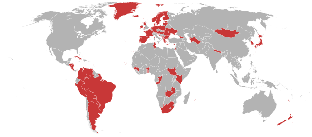
English: Map of the world with colour applied to countries with an official prohibition of all forms of corporal punishment of children, based on http://endcorporalpunishment.org/pages/progress/prohib_states.html. Counties coloured in are countries which have outlawed all forms of corporal punishment to children.
Українська: Країни з офіційною забороною (поза законом) всіх форм тілесних покарань дітей (позначені кольором), базовано на http://endcorporalpunishment.org/pages/progress/prohib_states.html. |
| Date | (UTC) |
| Source | |
| Auteur |
|
| Cette image a été retouchée, ce qui signifie qu'elle a été modifiée par ordinateur et est différente de l'image d'origine. Liste des modifications : coloured countries that have abolished corporal punishment. L'image d'origine se trouve ici : BlankMap-World6, compact.svg:
|
Moi, en tant que détenteur des droits d’auteur sur cette œuvre, je la publie sous la licence suivante :
| Moi, propriétaire des droits d’auteur sur cette œuvre, la place dans le domaine public. Ceci s'applique dans le monde entier. Dans certains pays, ceci peut ne pas être possible ; dans ce cas : J’accorde à toute personne le droit d’utiliser cette œuvre dans n’importe quel but, sans aucune condition, sauf celles requises par la loi. |
Journal des téléversements d’origine
This image is a derivative work of the following images:
- File:BlankMap-World6,_compact.svg licensed with PD-self
- 2008-12-02T18:21:18Z Lokal Profil 940x415 (1518276 Bytes) Reverted to version as of 14:51, 13 June 2008, new image has non of the complexity (i.e. colouring abilities etc.) of the old
- 2008-12-02T17:29:39Z Harbin 1326x601 (176022 Bytes)
- 2008-12-02T17:26:08Z Harbin 1425x625 (189017 Bytes)
- 2008-06-13T14:51:25Z Lokal Profil 940x415 (1518276 Bytes) Syncing with [[:Image:BlankMap-World6.svg]] version (01:30, March 29, 2008). Sadly enough the validator does not seem to like rdf element of the metadata although it should work acording to http://www.w3schools.com/rdf/rdf_ma
- 2008-02-08T20:55:35Z CarolSpears 940x415 (1528750 Bytes) validated, maybe
- 2007-12-14T19:51:17Z Lokal Profil 940x415 (1529675 Bytes) Readded an ocean object but this one is square instead of the original elliptic one
- 2007-12-14T19:19:56Z Lokal Profil 940x415 (1529845 Bytes) {{Information |Description=Detailed SVG map with grouping enabled to connect all non-contiguous parts of a country's territory for easy colouring. Smaller countries can also be represented by larger circles to show their data
Téléversé avec derivativeFX
Historique du fichier
Cliquer sur une date et heure pour voir le fichier tel qu'il était à ce moment-là.
| Date et heure | Vignette | Dimensions | Utilisateur | Commentaire | |
|---|---|---|---|---|---|
| actuel | 31 octobre 2023 à 17:38 | | 914 × 403 (1,29 Mio) | Hariboneagle927 | Philippines - pending |
| 2 octobre 2023 à 19:03 |  | 914 × 403 (1,29 Mio) | Wwklnd | Update: added Cuba, Zambia, Mauritius, Philippines | |
| 21 août 2022 à 03:49 |  | 914 × 403 (1,29 Mio) | Mutoso | Update Wales | |
| 20 octobre 2021 à 05:08 |  | 914 × 403 (1,28 Mio) | Ratherous | Update Guinea | |
| 20 octobre 2021 à 05:05 |  | 914 × 403 (1,28 Mio) | Ratherous | Update Colombia | |
| 7 avril 2021 à 13:49 |  | 914 × 403 (1,26 Mio) | Ratherous | South Korea | |
| 28 février 2020 à 19:58 |  | 914 × 403 (1,26 Mio) | Ratherous | Japan | |
| 23 octobre 2019 à 19:00 |  | 914 × 403 (1,26 Mio) | Ratherous | Georgia | |
| 5 octobre 2019 à 12:38 |  | 914 × 403 (1,19 Mio) | Maxí | Added Scotland | |
| 18 septembre 2019 à 14:41 |  | 914 × 403 (1,3 Mio) | Htonl | Update: South Africa finalized today by ruling of the Constitutional Court |
Utilisation du fichier
La page suivante utilise ce fichier :
Usage global du fichier
Les autres wikis suivants utilisent ce fichier :
- Utilisation sur ar.wikipedia.org
- Utilisation sur az.wikipedia.org
- Utilisation sur ba.wikipedia.org
- Utilisation sur bn.wikipedia.org
- Utilisation sur cs.wikipedia.org
- Utilisation sur cy.wikipedia.org
- Utilisation sur en.wikipedia.org
- Utilisation sur es.wikipedia.org
- Utilisation sur it.wikipedia.org
- Utilisation sur ky.wikipedia.org
- Utilisation sur pl.wikipedia.org
- Utilisation sur pt.wikipedia.org
- Utilisation sur ru.wikipedia.org
- Utilisation sur uk.wikipedia.org
- Utilisation sur zh-yue.wikipedia.org
- Utilisation sur zh.wikipedia.org