
Fichier:SJU Diagram.JPG
Taille de cet aperçu : 392 × 600 pixels. Autres résolutions : 157 × 240 pixels | 517 × 791 pixels.
Fichier d’origine (517 × 791 pixels, taille du fichier : 57 kio, type MIME : image/jpeg)
Ce fichier et sa description proviennent de Wikimedia Commons.
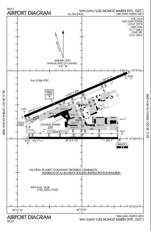
Description
| Description |
English: FAA Airport Diagram(link at bottom of the page)
commons:category:Luis Muñoz Marín International Airport commons:category:Federal Aviation Administration commons:category:MapsEspañol: Diagrama del Aeropuerto Internacional Luis Muñoz Marín de la Administración Federal de Aviación |
| Source | FAA |
| Auteur | FAA |
Around past April-May, I uploaded this image updated, that included the new taxiway on the south of the airport. The updated version appeared on the "file history" section. I don't know why it was removed. Can anyone update this image?, and that have better resolution too?
Conditions d’utilisation
This image or file is a work of a Federal Aviation Administration employee, taken or made as part of that person's official duties. As a work of the U.S. federal government, the image is in the public domain in the United States.
|
 |
Journal des téléversements d’origine
La page de description originale était ici. Tous les noms d'utilisateur qui suivent se rapportent à en.wikipedia.
- 2006-10-28 15:21 Djxixa 517×791× (58780 bytes) FAA Airport Diagram(link at bottom of the page)
Historique du fichier
Cliquer sur une date et heure pour voir le fichier tel qu'il était à ce moment-là.
| Date et heure | Vignette | Dimensions | Utilisateur | Commentaire | |
|---|---|---|---|---|---|
| actuel | 29 avril 2010 à 19:05 | | 517 × 791 (57 kio) | File Upload Bot (Magnus Manske) | {{BotMoveToCommons|en.wikipedia|year={{subst:CURRENTYEAR}}|month={{subst:CURRENTMONTHNAME}}|day={{subst:CURRENTDAY}}}} {{Information |Description={{en|FAA Airport Diagram(link at bottom of the page) [[:en:commons:category:Luis Muñoz Marín Internation |
Utilisation du fichier
La page suivante utilise ce fichier :
Usage global du fichier
Les autres wikis suivants utilisent ce fichier :
- Utilisation sur ast.wikipedia.org
- Utilisation sur ca.wikipedia.org
- Utilisation sur es.wikipedia.org
- Utilisation sur fa.wikipedia.org
- Utilisation sur ja.wikipedia.org
- Utilisation sur ru.wikipedia.org
- Utilisation sur tg.wikipedia.org