
Fichier:Serbia-WW1-4.jpg
Taille de cet aperçu : 799 × 271 pixels. Autres résolutions : 320 × 109 pixels | 1 023 × 347 pixels.
Fichier d’origine (1 023 × 347 pixels, taille du fichier : 99 kio, type MIME : image/jpeg)
Ce fichier et sa description proviennent de Wikimedia Commons.

|
This map has been uploaded by Electionworld from en.wikipedia.org to enable the |
Description
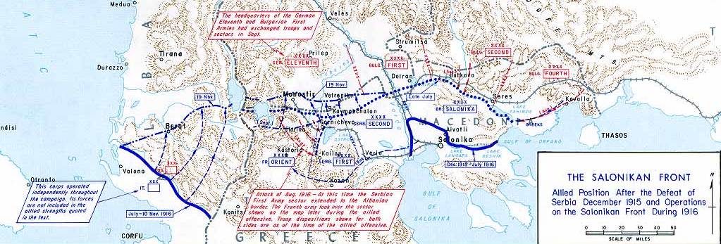
| Description |
English: Operations at the border of Greece and Serbia, 1916.
his map was created by the Department of Military Art and Engineering, at the U.S. Military Academy (West Point). The initial version was created under the supervision of General Vincent Esposito in 1959. It is now available on the West Point |
||||||
| Date | |||||||
| Source | West Point | ||||||
| Auteur | General Vincent Esposito | ||||||
| Autorisation (Réutilisation de ce fichier) |
|
||||||
| Autres versions |
  |
||||||

Historique du fichier
Cliquer sur une date et heure pour voir le fichier tel qu'il était à ce moment-là.
| Date et heure | Vignette | Dimensions | Utilisateur | Commentaire | |
|---|---|---|---|---|---|
| actuel | 21 décembre 2006 à 23:55 | 1 023 × 347 (99 kio) | Electionworld | {{ew|en|Cglassey}} == Summary == Operations at the border of Greece and Serbia, 1916. his map was created by the Department of Military Art and Engineering, at the U.S. Military Academy (West Point). The initial version was created under the supervision |
Utilisation du fichier
Les 6 pages suivantes utilisent ce fichier :
Usage global du fichier
Les autres wikis suivants utilisent ce fichier :
- Utilisation sur ar.wikipedia.org
- Utilisation sur azb.wikipedia.org
- Utilisation sur az.wikipedia.org
- Utilisation sur be-tarask.wikipedia.org
- Utilisation sur be.wikipedia.org
- Utilisation sur bg.wikipedia.org
- Utilisation sur bs.wikipedia.org
- Utilisation sur ca.wikipedia.org
- Utilisation sur de.wikipedia.org
- Utilisation sur el.wikipedia.org
- Utilisation sur en.wikipedia.org
- History of modern Macedonia (Greece)
- Maurice Sarrail
- Macedonian front
- Battle of Doiran (1917)
- Greece during World War I
- Monastir offensive
- Autonomous Province of Korçë
- Bulgarian occupation of Albania
- World War I in Albania
- Battle of the Crna Bend (1917)
- User:GerardM/Battles including the Ottoman Empire
- User:BoDr12/sandbox
- User:Falcaorib/Balkans maps
- User:Falcaorib/Serbia, Yugoslavia and Albania
- User:Falcaorib/Bulgaria and North Macedonia
- Utilisation sur es.wikipedia.org
- Utilisation sur fa.wikipedia.org
- Utilisation sur he.wikipedia.org
- Utilisation sur hr.wikipedia.org
- Utilisation sur hu.wikipedia.org
- Utilisation sur it.wikipedia.org
Voir davantage sur l’utilisation globale de ce fichier.