
Fichier:Tectonic map of southwest Japan.png

Taille de cet aperçu : 800 × 534 pixels. Autres résolutions : 320 × 213 pixels | 640 × 427 pixels | 877 × 585 pixels.
Fichier d’origine (877 × 585 pixels, taille du fichier : 251 kio, type MIME : image/png)
Ce fichier et sa description proviennent de Wikimedia Commons.
Description
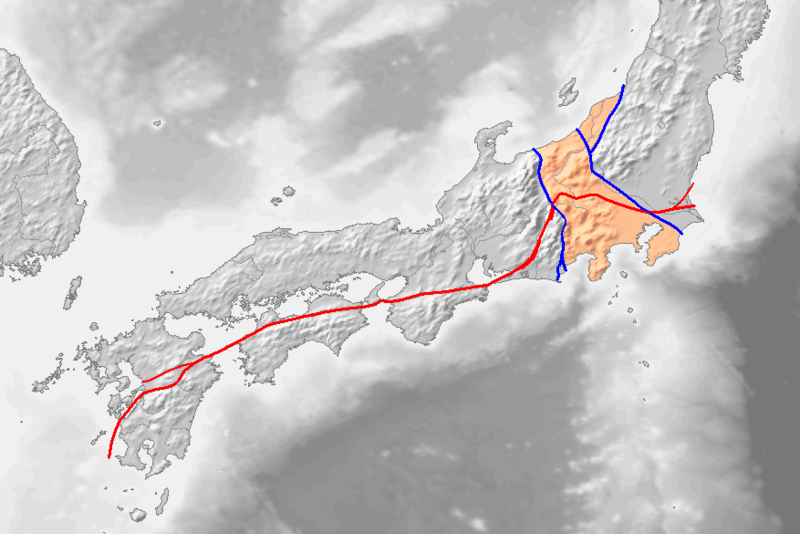
九州地方~関東地方の地質構造図。Image:Topographic30deg N30E120.pngをもとに、[1] copie d'archive sur Wayback Machine, [2]を参考に作成。
線や色分けの意味は次のとおり。
- 赤線:ja:中央構造線
- 左の青線:ja:糸魚川静岡構造線
- 右の青線:ja:柏崎千葉構造線、新発田小出構造線
- 薄い赤色:ja:フォッサマグナ地域
赤・青の太い線は現在主力の説、細い線は主力ではない説。
Conditions d’utilisation

|
Vous avez la permission de copier, distribuer et modifier ce document selon les termes de la GNU Free Documentation License version 1.2 ou toute version ultérieure publiée par la Free Software Foundation, sans sections inaltérables, sans texte de première page de couverture et sans texte de dernière page de couverture. Un exemplaire de la licence est inclus dans la section intitulée GNU Free Documentation License. |
| Ce fichier est disponible selon les termes de la licence Creative Commons Attribution – Partage dans les Mêmes Conditions 3.0 (non transposée). | ||
| ||
| Ce bandeau de licence a été ajouté à ce fichier dans le cadre de la procédure de mise à jour des licences des images sous GFDL. |
Historique du fichier
Cliquer sur une date et heure pour voir le fichier tel qu'il était à ce moment-là.
| Date et heure | Vignette | Dimensions | Utilisateur | Commentaire | |
|---|---|---|---|---|---|
| actuel | 6 janvier 2017 à 15:17 | | 877 × 585 (251 kio) | Æskja | w:ja:ノート:中央構造線で説明します。Reverted to version as of 14:45, 5 January 2017 (UTC) |
| 6 janvier 2017 à 07:39 |  | 877 × 585 (198 kio) | Hyper neo | Wrong Information | |
| 5 janvier 2017 à 16:45 |  | 877 × 585 (251 kio) | Æskja | Reverted to version as of 11:47, 18 June 2011 (UTC) | |
| 5 septembre 2016 à 17:15 |  | 877 × 585 (198 kio) | Hyper neo | renew (remove wrong lines in Kyushu island) | |
| 18 juin 2011 à 13:47 |  | 877 × 585 (251 kio) | Qrsk075 | renew | |
| 9 août 2006 à 04:53 |  | 877 × 585 (215 kio) | Pekachu | 九州地方~関東地方の地質構造図。Image:Topographic30deg N30E120.pngをもとに、[http://www.osk.janis.or.jp/~mtl-muse/subindex03.htm], [http://www3.cnet.ne.jp/pas31225og/FosMagna.htm]を参考に作成。 線や色分けの意味は� |
Utilisation du fichier
Les 7 pages suivantes utilisent ce fichier :
Usage global du fichier
Les autres wikis suivants utilisent ce fichier :
- Utilisation sur ast.wikipedia.org
- Utilisation sur de.wikipedia.org
- Utilisation sur en.wikipedia.org
- Utilisation sur es.wikipedia.org
- Utilisation sur it.wikipedia.org
- Utilisation sur ja.wikipedia.org
- Utilisation sur ja.wikibooks.org
- Utilisation sur ko.wikipedia.org
- Utilisation sur ru.wikipedia.org
- Utilisation sur sl.wikipedia.org
- Utilisation sur uk.wikipedia.org
- Utilisation sur www.wikidata.org
- Utilisation sur zh.wikipedia.org