
Fichier:Thessaly.jpg
Taille de cet aperçu : 665 × 600 pixels. Autres résolutions : 266 × 240 pixels | 532 × 480 pixels | 894 × 806 pixels.
Fichier d’origine (894 × 806 pixels, taille du fichier : 1,18 Mio, type MIME : image/jpeg)
Ce fichier et sa description proviennent de Wikimedia Commons.
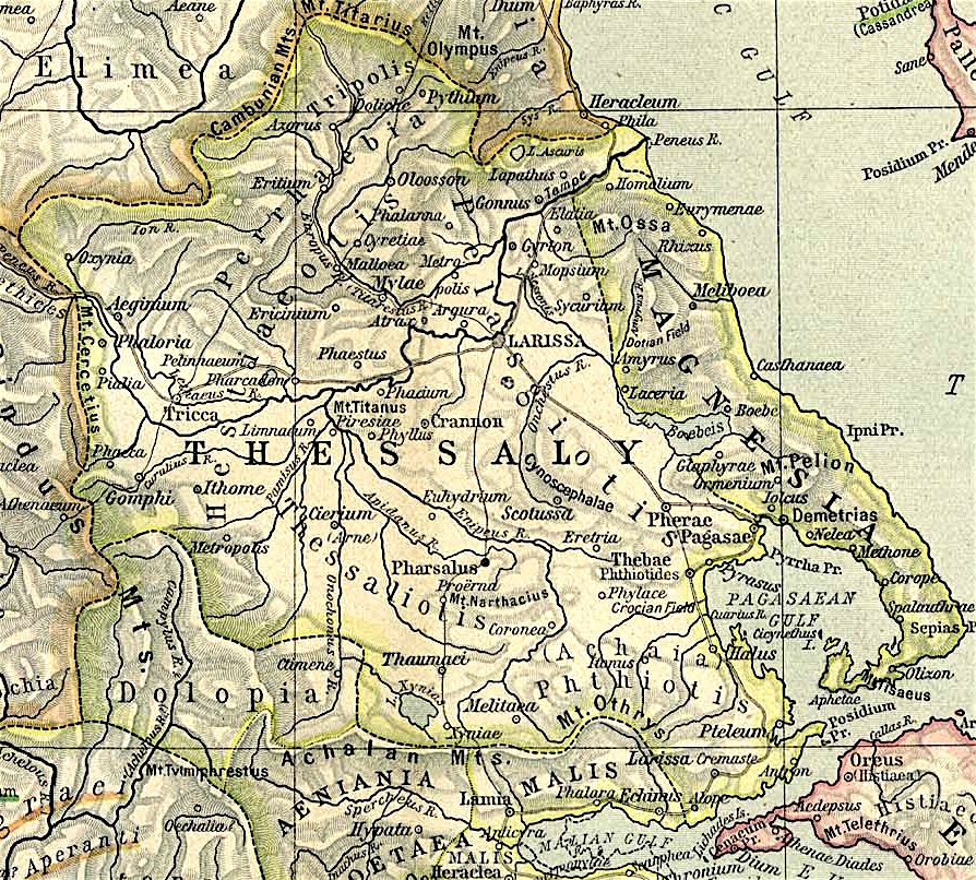
Map of Thessaly, cropped from old public domain map of Greece, from the Perry-Castañeda Library Map Collection, Historical Atlas by William R. Shepherd north, south
Ce fichier est disponible selon les termes de la licence Creative Commons Attribution 3.0 Non transposée.
- Vous êtes libre :
- de partager – de copier, distribuer et transmettre cette œuvre
- d’adapter – de modifier cette œuvre
- Sous les conditions suivantes :
- paternité – Vous devez donner les informations appropriées concernant l'auteur, fournir un lien vers la licence et indiquer si des modifications ont été faites. Vous pouvez faire cela par tout moyen raisonnable, mais en aucune façon suggérant que l’auteur vous soutient ou approuve l’utilisation que vous en faites.
Historique du fichier
Cliquer sur une date et heure pour voir le fichier tel qu'il était à ce moment-là.
| Date et heure | Vignette | Dimensions | Utilisateur | Commentaire | |
|---|---|---|---|---|---|
| actuel | 1 novembre 2021 à 14:40 | | 894 × 806 (1,18 Mio) | Claude Zygiel | Lighter |
| 2 octobre 2010 à 17:44 |  | 894 × 806 (680 kio) | Cplakidas | widened to include Magnesia, which was considered part of wider Thessaly | |
| 12 décembre 2006 à 10:22 |  | 769 × 778 (226 kio) | Roke~commonswiki | Map of Thessaly, cropped from old public domain map of Greece, from the Perry-Castañeda Library Map Collection, Historical Atlas by William R. Shepherd [http://www.lib.utexas.edu/maps/historical/shepherd/greece_ancient_n_ref_1926.jpg north], [http://www. |
Utilisation du fichier
Les 18 pages suivantes utilisent ce fichier :
Usage global du fichier
Les autres wikis suivants utilisent ce fichier :
- Utilisation sur an.wikipedia.org
- Utilisation sur bg.wikipedia.org
- Utilisation sur ca.wikipedia.org
- Utilisation sur ceb.wikipedia.org
- Utilisation sur cs.wikipedia.org
- Utilisation sur de.wikipedia.org
- Utilisation sur el.wikipedia.org
- Utilisation sur en.wikipedia.org
- Thessaly
- Pagasae
- Demetrias
- Phylace (Thessaly)
- Pherae
- Tripolis Larisaia
- Tripolis (Perrhaebia)
- Pythion
- Doliche (Thessaly)
- History of Thessaly
- Palaepharsalus
- Argissa Magoula
- Eurymenae
- Amphrysus
- Gomphi
- Halos (Thessaly)
- Homolium
- Rhizus
- Tricca
- Phalanna
- Perrhaebia
- Pelasgiotis
- Ancient Thessaly
- Pimpleia
- Pelinna
- Pharcadon
- Argos Pelasgikon
- Boebe (Thessaly)
Voir davantage sur l’utilisation globale de ce fichier.