
Fichier:ECDM 20230913 FL Libya.pdf

Taille de cet aperçu JPG pour ce fichier PDF : 800 × 566 pixels. Autres résolutions : 320 × 226 pixels | 640 × 453 pixels | 1 024 × 725 pixels | 1 280 × 906 pixels | 2 479 × 1 754 pixels.
Fichier d’origine (2 479 × 1 754 pixels, taille du fichier : 1,21 Mio, type MIME : application/pdf)
Ce fichier et sa description proviennent de Wikimedia Commons.
Description
| Description |
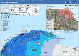
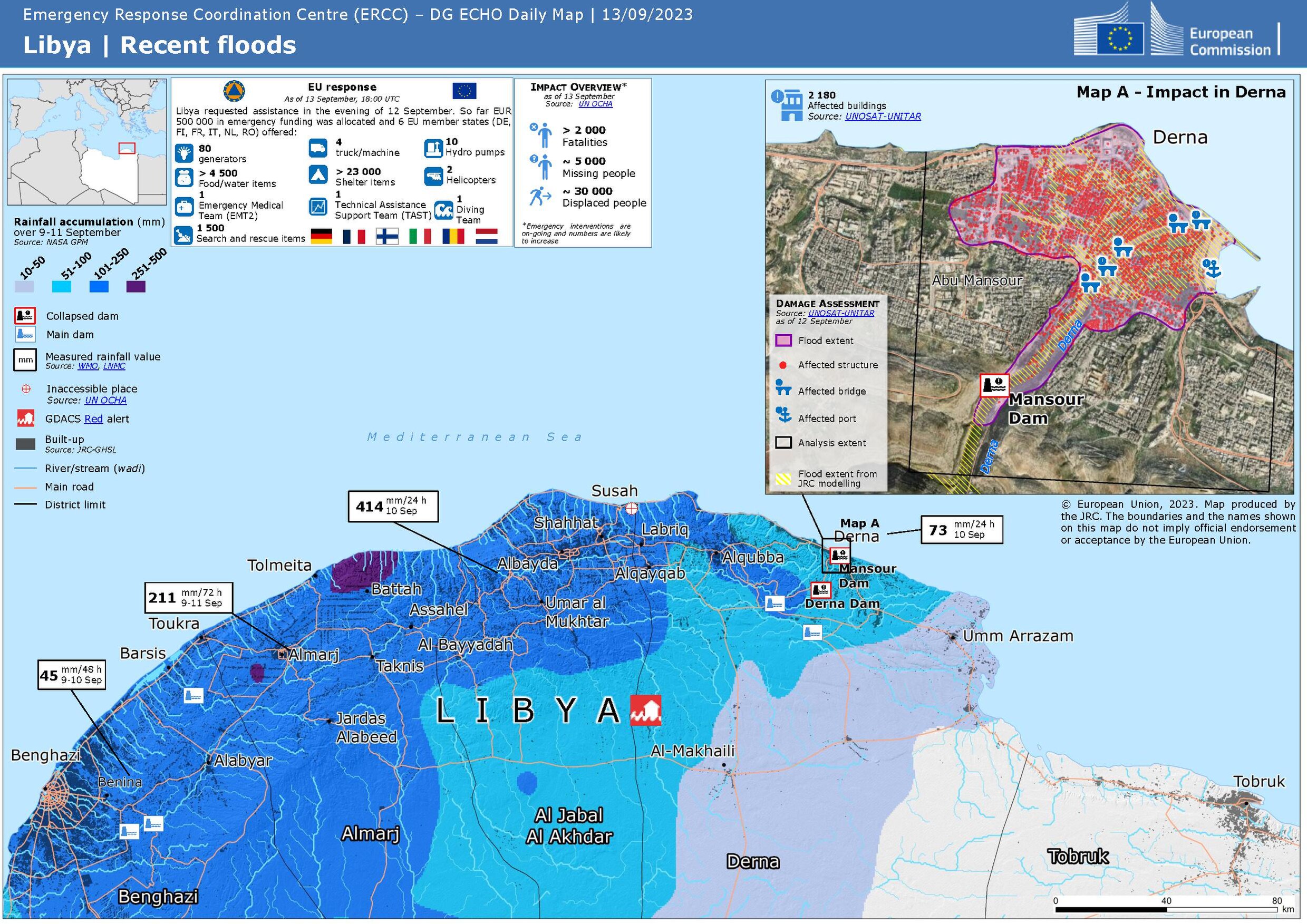
Deutsch: Überschwemmungen in Libyen im Spetember 2023 - ECHO Daily Map vom 13. September 2023
English: Floods in Libya, September 2023 - ECHO Daily Map of 13 September 2023 |
| Date | |
| Source | https://erccportal.jrc.ec.europa.eu/ECHO-Products/Maps#/maps/4636 |
| Auteur |
ERCC - Emergency Response Coordination Centre Sources: OCHA, NASA GPM, WMO, LNMC, GDACS, UNOSAT |
Conditions d’utilisation
Public documents (any content whatever its medium) produced by the Commission or by entities on its behalf published by the Commission or the Publications Office or which have not been published for economic or other practical reasons, such as studies, reports and other data shall be made available for reuse unless otherwise specified[1] without restrictions according to 2011/833/EU: Commission Decision of 12 December 2011 on the reuse of Commission documents
Note: Content on ec.europa.eu or its data portal is published with the specified restrictions of the CC BY 4.0 license.
| |
Historique du fichier
Cliquer sur une date et heure pour voir le fichier tel qu'il était à ce moment-là.
| Date et heure | Vignette | Dimensions | Utilisateur | Commentaire | |
|---|---|---|---|---|---|
| actuel | 14 avril 2024 à 16:04 |  | 2 479 × 1 754 (1,21 Mio) | Don-vip | fixed number of EU states in legend (6, not 5) |
| 13 septembre 2023 à 22:47 |  | 2 479 × 1 754 (1,21 Mio) | Lupe | Uploaded a work by ERCC - Emergency Response Coordination Centre Sources: OCHA, NASA GPM, WMO, LNMC, GDACS, UNOSAT from https://erccportal.jrc.ec.europa.eu/ECHO-Products/Maps#/maps/4636 with UploadWizard |
Utilisation du fichier
Les 2 pages suivantes utilisent ce fichier :
Usage global du fichier
Les autres wikis suivants utilisent ce fichier :
- Utilisation sur be.wikipedia.org
- Utilisation sur bn.wikipedia.org
- Utilisation sur ca.wikipedia.org
- Utilisation sur de.wikipedia.org
- Utilisation sur en.wikipedia.org
- Utilisation sur ko.wikipedia.org