
Fichier:NPS assateague-island-inset-map.pdf

Taille de cet aperçu JPG pour ce fichier PDF : 576 × 600 pixels. Autres résolutions : 230 × 240 pixels | 461 × 480 pixels | 752 × 783 pixels.
Fichier d’origine (752 × 783 pixels, taille du fichier : 296 kio, type MIME : application/pdf)
Ce fichier et sa description proviennent de Wikimedia Commons.
Description
| Description |
English: Detail map of Assateague Island, focusing on the roads and trails in the northern section of the park. |
| Date | |
| Source | U.S. National Park Service (http://npmaps.com/wp-content/uploads/assateague-island-inset-map.pdf) |
| Auteur | U.S. National Park Service, restoration/cleanup by Matt Holly |
| Autres versions |
 |
Conditions d’utilisation
| Cette image ou ce document multimédia contient des éléments basés sur une œuvre d'un employé du National Park Service, créé dans le cadre des tâches officielles de cette personne. En tant qu'œuvre du Gouvernement fédéral des États-Unis, une telle œuvre se trouve dans le domaine public aux États-Unis. Voir NPS website et NPS copyright policy pour plus d'informations. |
Historique du fichier
Cliquer sur une date et heure pour voir le fichier tel qu'il était à ce moment-là.
| Date et heure | Vignette | Dimensions | Utilisateur | Commentaire | |
|---|---|---|---|---|---|
| actuel | 16 mai 2017 à 13:57 | 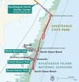 | 752 × 783 (296 kio) | RKBot | =={{int:filedesc}}== {{Information |description= {{en|1=Detail map of Assateague Island, focusing on the roads and trails in the northern section of the park.}} |date= 2016-02-20 |source= U.S. National Park Service (http://npmaps.com/wp-content/uploads... |
Utilisation du fichier
La page suivante utilise ce fichier :